Applied Geography ( IF 4.732 ) Pub Date : 2021-06-23 , DOI: 10.1016/j.apgeog.2021.102495 Ali Reza Nafarzadegan , Zohre Ebrahimi-Khusfi , Mohamad Kazemi
|
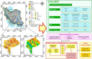
Aeolian dust emission is a serious environmental hazard in central Iran. We attempted to map the dust emission prone (DEP) areas in this region of Iran using the most accurate model among the random forest (RF), conditional RF (CRF), parallel RF (PRF), and extremely randomized trees (ERT) models. These models were evaluated using the Taylor diagram, Nash Sutcliffe coefficient, and Kling–Gupta efficiency. The generated map of DEP areas was also validated based on an aerosols optical depth (AOD) dataset. The Shapely values were used to determine the contribution of factors controlling dust events in DEP areas. The high performance and reliability of the ERT model for mapping DEP territories were confirmed by both error assessment statistics and reclassified AOD map. Using the ERT-generated map, five dust generation susceptibility classes including very low (20.16%), low (19.99%), moderate (19.82%), high (24.11%), and very high (15.92%) were identified in the study region. Drought severity, solar radiation, soil moisture, geology, soil sand content, bulk density, vegetation cover, land use, and slope were detected as the key features controlling dust emissions in central Iran. These results are useful for developing programs to reduce dust emissions hazards in DEP areas, particularly in central Iran.
中文翻译:
使用特征提取和预测算法的沙尘排放易发干旱区空间表征
风尘排放是伊朗中部严重的环境危害。我们尝试使用随机森林 (RF)、条件 RF (CRF)、并行 RF (PRF) 和极端随机树 (ERT) 模型中最准确的模型绘制伊朗该地区的粉尘排放易发 (DEP) 区域. 这些模型使用泰勒图、Nash Sutcliffe 系数和 Kling-Gupta 效率进行评估。生成的 DEP 区域地图也基于气溶胶光学深度 (AOD) 数据集进行了验证。Shapely 值用于确定控制 DEP 区域沙尘事件的因素的贡献。错误评估统计数据和重新分类的 AOD 地图都证实了 ERT 模型用于绘制 DEP 领土的高性能和可靠性。使用 ERT 生成的地图,在研究区域确定了五个粉尘产生敏感性等级,包括极低 (20.16%)、低 (19.99%)、中等 (19.82%)、高 (24.11%) 和极高 (15.92%)。干旱严重程度、太阳辐射、土壤湿度、地质、土壤含沙量、容重、植被覆盖、土地利用和坡度被检测为控制伊朗中部粉尘排放的关键特征。这些结果有助于制定减少 DEP 地区(尤其是伊朗中部)粉尘排放危害的计划。


 京公网安备 11010802027423号