ISPRS Journal of Photogrammetry and Remote Sensing ( IF 12.7 ) Pub Date : 2021-06-24 , DOI: 10.1016/j.isprsjprs.2021.06.002 Gabriel Henrique de Almeida Pereira , Andre Minoro Fusioka , Bogdan Tomoyuki Nassu , Rodrigo Minetto
|
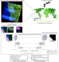
Active fire detection in satellite imagery is of critical importance to the management of environmental conservation policies, supporting decision-making and law enforcement. This is a well established field, with many techniques being proposed over the years, usually based on pixel or region-level comparisons involving sensor-specific thresholds and neighborhood statistics. In this paper, we address the problem of active fire detection using deep learning techniques. In recent years, deep learning techniques have been enjoying an enormous success in many fields, but their use for active fire detection is relatively new, with open questions and demand for datasets and architectures for evaluation. This paper addresses these issues by introducing a new large-scale dataset for active fire detection, with over 150,000 image patches (more than 200 GB of data) extracted from Landsat-8 images captured around the world in August and September 2020, containing wildfires in several locations. The dataset was split in two parts, and contains 10-band spectral images with associated outputs, produced by three well known handcrafted algorithms for active fire detection in the first part, and manually annotated masks in the second part. We also present a study on how different convolutional neural network architectures can be used to approximate these handcrafted algorithms, and how models trained on automatically segmented patches can be combined to achieve better performance than the original algorithms – with the best combination having 87.2% precision and 92.4% recall on our manually annotated dataset. The proposed dataset, source codes and trained models are available on Github (https://github.com/pereira-gha/activefire), creating opportunities for further advances in the field.
中文翻译:
Landsat-8 图像中的主动火灾检测:大规模数据集和深度学习研究
卫星图像中的主动火灾探测对于环境保护政策的管理、支持决策和执法至关重要。这是一个成熟的领域,多年来提出了许多技术,通常基于像素或区域级别的比较,涉及特定于传感器的阈值和邻域统计数据。在本文中,我们解决了使用深度学习技术进行主动火灾检测的问题。近年来,深度学习技术在许多领域取得了巨大成功,但它们在主动火灾检测中的应用相对较新,对数据集和架构的评估存在开放性问题和需求。本文通过引入一个新的用于主动火灾探测的大规模数据集来解决这些问题,该数据集有超过 150 个,从 2020 年 8 月和 2020 年 9 月在世界各地捕获的 Landsat-8 图像中提取的 000 个图像块(超过 200 GB 的数据),其中包含多个地点的野火。数据集分为两部分,包含具有相关输出的 10 波段光谱图像,第一部分由三种著名的手工算法生成,用于主动火灾检测,第二部分是手动注释的掩码。我们还研究了如何使用不同的卷积神经网络架构来近似这些手工算法,以及如何组合在自动分割补丁上训练的模型以获得比原始算法更好的性能——最佳组合具有 87.2% 的精度和92.4% 回忆我们手动注释的数据集。建议的数据集,


 京公网安备 11010802027423号