当前位置:
X-MOL 学术
›
Atmos. Sci. Lett.
›
论文详情
Our official English website, www.x-mol.net, welcomes your feedback! (Note: you will need to create a separate account there.)
Water availability trends across water management zones in Uganda
Atmospheric Science Letters ( IF 3 ) Pub Date : 2021-06-21 , DOI: 10.1002/asl.1059 Charles Onyutha 1 , Arnold Asiimwe 1 , Lawrence Muhwezi 1 , Ambrose Mubialiwo 1, 2
Atmospheric Science Letters ( IF 3 ) Pub Date : 2021-06-21 , DOI: 10.1002/asl.1059 Charles Onyutha 1 , Arnold Asiimwe 1 , Lawrence Muhwezi 1 , Ambrose Mubialiwo 1, 2
Affiliation
|
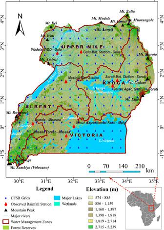
This study assessed trends in gridded (0.25° × 0.25°) Climate Forecast System Reanalysis (CFSR) precipitation, potential evapotranspiration (PET), and precipitation minus PET (PMP) across the four water management zones (WMZs) in Uganda including Kyoga, Victoria, Albert, and Upper Nile. The period considered was 1979–2013. Validation of CFSR datasets was conducted using precipitation observed at eight meteorological stations across the country. Observed precipitation trend direction was satisfactorily reproduced by CFSR data extracted at five out of eight stations. Negative (positive) values of long-term PMP mean were considered to indicate areas characterized by water scarcity (surplus). Areas with large positive PMP were confined to Lake Victoria and mountains such as Rwenzori and Elgon. The largest negative PMP values were in the arid and semi-arid areas of north and northeastern Uganda. The null hypothesis H0 (no trend) was rejected (p < 0.05) for increasing annual precipitation trends across the various WMZs except in the extreme eastern parts of the Upper Nile, Kyoga, and Victoria WMZs (or areas along the boundary of Uganda and Kenya). The H0 (no trend) was rejected (p < 0.05) for decreasing trends in annual PET over West Nile region of the Upper Nile, western parts of Victoria, and the Albert WMZs. For increasing trend in PMP, the H0 (no trend) was rejected (p < 0.05) across the various WMZs except around the Mount Elgon area. The study findings are relevant for planning of water resources management across the different WMZs in the country.
中文翻译:

乌干达水资源管理区的水资源供应趋势
本研究评估了乌干达四个水资源管理区 (WMZ) 的网格化 (0.25° × 0.25°) 气候预测系统再分析 (CFSR) 降水、潜在蒸散量 (PET) 和降水减去 PET (PMP) 的趋势,其中包括 Kyoga、Victoria 、阿尔伯特和上尼罗河。所考虑的时期是 1979-2013 年。CFSR 数据集的验证是使用在全国八个气象站观测到的降水进行的。在八个站点中的五个站点中提取的 CFSR 数据令人满意地再现了观测到的降水趋势方向。长期 PMP 平均值的负(正)值被认为表示以缺水(过剩)为特征的区域。PMP 呈阳性的地区仅限于维多利亚湖和鲁文佐里 (Rwenzori) 和埃尔贡 (Elgon) 等山脉。最大的负 PMP 值出现在乌干达北部和东北部的干旱和半干旱地区。零假设H 0(无趋势)被拒绝(p < 0.05),因为除了上尼罗河、基奥加和维多利亚 WMZ 的极端东部地区(或沿乌干达和肯尼亚边界的地区),各个 WMZ 的年降水量趋势增加。的ħ 0(没有趋势)被拒绝(p <0.05),用于在所述上尼罗的西尼罗河区域,维多利亚的西部地区,和Albert WMZs减小在年度PET的趋势。对于 PMP 的增加趋势, 除埃尔冈山地区外,各个 WMZ的H 0(无趋势)被拒绝(p < 0.05)。研究结果与该国不同 WMZ 的水资源管理规划相关。
更新日期:2021-06-21
中文翻译:
乌干达水资源管理区的水资源供应趋势
本研究评估了乌干达四个水资源管理区 (WMZ) 的网格化 (0.25° × 0.25°) 气候预测系统再分析 (CFSR) 降水、潜在蒸散量 (PET) 和降水减去 PET (PMP) 的趋势,其中包括 Kyoga、Victoria 、阿尔伯特和上尼罗河。所考虑的时期是 1979-2013 年。CFSR 数据集的验证是使用在全国八个气象站观测到的降水进行的。在八个站点中的五个站点中提取的 CFSR 数据令人满意地再现了观测到的降水趋势方向。长期 PMP 平均值的负(正)值被认为表示以缺水(过剩)为特征的区域。PMP 呈阳性的地区仅限于维多利亚湖和鲁文佐里 (Rwenzori) 和埃尔贡 (Elgon) 等山脉。最大的负 PMP 值出现在乌干达北部和东北部的干旱和半干旱地区。零假设H 0(无趋势)被拒绝(p < 0.05),因为除了上尼罗河、基奥加和维多利亚 WMZ 的极端东部地区(或沿乌干达和肯尼亚边界的地区),各个 WMZ 的年降水量趋势增加。的ħ 0(没有趋势)被拒绝(p <0.05),用于在所述上尼罗的西尼罗河区域,维多利亚的西部地区,和Albert WMZs减小在年度PET的趋势。对于 PMP 的增加趋势, 除埃尔冈山地区外,各个 WMZ的H 0(无趋势)被拒绝(p < 0.05)。研究结果与该国不同 WMZ 的水资源管理规划相关。


 京公网安备 11010802027423号