ISPRS Journal of Photogrammetry and Remote Sensing ( IF 12.7 ) Pub Date : 2021-06-17 , DOI: 10.1016/j.isprsjprs.2021.06.005 Dario Schulz , He Yin , Bernhard Tischbein , Sarah Verleysdonk , Rabani Adamou , Navneet Kumar
|
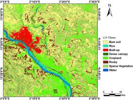
Land use maps describe the spatial distribution of natural resources, cultural landscapes, and human settlements, serving as an important planning tool for decision makers. In the Sahel area, such information is valuable for risk management and mitigation in challenging sectors like food security, flood control, and urban planning. Due to its uniform quality across large areas in regular time steps, remote sensing imageries are essential input for producing land use maps. However, spatially and temporally heterogeneous landscapes in Sahel make classification of landscape features difficult. Our overall goal is to create an accurate, high resolution land use map covering Niamey, the capital of Niger and its surroundings which represents the unique landscape features in the Sahel using Sentinel-1 and Sentinel-2 archives. We assessed the performance of three commonly used classifiers (i.e. Maximum Likelihood (ML), Support Vector Machine (SVM) and Random Forest (RF)) for land use classification. To understand the utility of different features from Sentinel-1 and Sentinel-2 imagery for classification, we performed feature selection and compared mapping accuracies with and without feature selection. To leverage the strength of each classifier, we developed a classifier ensemble (CE) map based on the mapping accuracy of each land use class and each classifier. The results of this study showed that the performance of individual classifiers depends on feature selection method and accuracies can be improved by combining different classifiers. The ensemble map had an overall accuracy of 72 ± 3.9% and it was found superior in terms of accuracy particularly with respect to built-up areas compared to the existing global land cover products in the study area. Our classification scheme also better characterized the regional environment in the Sahel. For example, we mapped rice and bare rocks that have important regional implication, which are not included in the existing products. Overall, our approach highlights the potentiality of combining multi-modal imageries and multiple classifiers for mapping a heterogenous environment such as the Sahel with high spatial resolution.
中文翻译:
在萨赫勒尼日尔的异质景观中使用 Sentinel-1 和 Sentinel-2 时间序列绘制土地利用图
土地利用图描述了自然资源、文化景观和人类住区的空间分布,是决策者的重要规划工具。在萨赫勒地区,此类信息对于粮食安全、防洪和城市规划等具有挑战性的部门的风险管理和缓解非常有价值。由于其在固定时间步长内在大面积区域内具有统一的质量,因此遥感影像是制作土地利用地图的必要输入。然而,萨赫勒地区时空异质的景观使景观特征分类变得困难。我们的总体目标是使用 Sentinel-1 和 Sentinel-2 档案创建一个准确、高分辨率的土地利用地图,覆盖尼日尔首都尼亚美及其周边地区,代表萨赫勒地区独特的景观特征。我们评估了三种常用分类器(即最大似然 (ML)、支持向量机 (SVM) 和随机森林 (RF))用于土地利用分类的性能。为了了解 Sentinel-1 和 Sentinel-2 图像中不同特征的分类效用,我们执行了特征选择并比较了有和没有特征选择的映射精度。为了利用每个分类器的优势,我们根据每个土地利用类别和每个分类器的映射精度开发了一个分类器集成 (CE) 地图。本研究的结果表明,单个分类器的性能取决于特征选择方法,并且可以通过组合不同的分类器来提高精度。集成图的整体精度为 72 ± 3。9% 并且发现与研究区域中现有的全球土地覆盖产品相比,它在准确性方面尤其是在建成区方面更为出色。我们的分类方案还更好地描述了萨赫勒地区的区域环境。例如,我们绘制了具有重要区域意义的水稻和裸岩,这些都没有包含在现有产品中。总体而言,我们的方法突出了结合多模态图像和多个分类器以绘制具有高空间分辨率的异质环境(例如萨赫勒)的潜力。不包含在现有产品中。总体而言,我们的方法突出了结合多模态图像和多个分类器以绘制具有高空间分辨率的异质环境(例如萨赫勒地区)的潜力。不包含在现有产品中。总体而言,我们的方法突出了结合多模态图像和多个分类器以绘制具有高空间分辨率的异质环境(例如萨赫勒地区)的潜力。


 京公网安备 11010802027423号