当前位置:
X-MOL 学术
›
Hydrol. Process.
›
论文详情
Our official English website, www.x-mol.net, welcomes your feedback! (Note: you will need to create a separate account there.)
A multi-sensor evaluation of precipitation uncertainty for landslide-triggering storm events
Hydrological Processes ( IF 3.2 ) Pub Date : 2021-05-31 , DOI: 10.1002/hyp.14260 Elsa S Culler 1, 2 , Andrew M Badger 3, 4 , Justin Toby Minear 2 , Kristy F Tiampo 2, 5 , Spencer D Zeigler 5 , Ben Livneh 1, 2
Hydrological Processes ( IF 3.2 ) Pub Date : 2021-05-31 , DOI: 10.1002/hyp.14260 Elsa S Culler 1, 2 , Andrew M Badger 3, 4 , Justin Toby Minear 2 , Kristy F Tiampo 2, 5 , Spencer D Zeigler 5 , Ben Livneh 1, 2
Affiliation
|
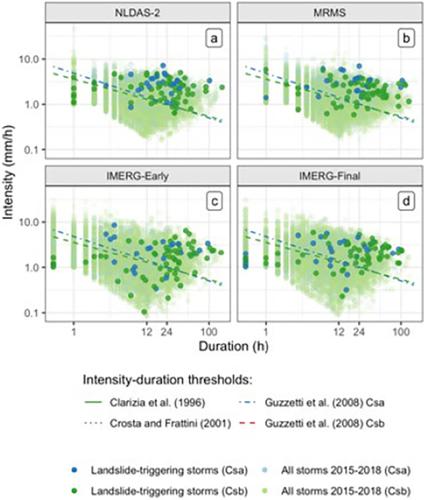
Extreme precipitation can have profound consequences for communities, resulting in natural hazards such as rainfall-triggered landslides that cause casualties and extensive property damage. A key challenge to understanding and predicting rainfall-triggered landslides comes from observational uncertainties in the depth and intensity of precipitation preceding the event. Practitioners and researchers must select from a wide range of precipitation products, often with little guidance. Here we evaluate the degree of precipitation uncertainty across multiple precipitation products for a large set of landslide-triggering storm events and investigate the impact of these uncertainties on predicted landslide probability using published intensity–duration thresholds. The average intensity, peak intensity, duration, and NOAA-Atlas return periods are compared ahead of 177 reported landslides across the continental United States and Canada. Precipitation data are taken from four products that cover disparate measurement methods: near real-time and post-processed satellite (IMERG), radar (MRMS), and gauge-based (NLDAS-2). Landslide-triggering precipitation was found to vary widely across precipitation products with the depth of individual storm events diverging by as much as 296 mm with an average range of 51 mm. Peak intensity measurements, which are typically influential in triggering landslides, were also highly variable with an average range of 7.8 mm/h and as much as 57 mm/h. The two products more reliant upon ground-based observations (MRMS and NLDAS-2) performed better at identifying landslides according to published intensity–duration storm thresholds, but all products exhibited hit ratios of greater than 0.56. A greater proportion of landslides were predicted when including only manually verified landslide locations. We recommend practitioners consider low-latency products like MRMS for investigating landslides, given their near-real time data availability and good performance in detecting landslides. Practitioners would be well-served considering more than one product as a way to confirm intense storm signals and minimize the influence of noise and false alarms.
中文翻译:

滑坡触发风暴事件降水不确定性的多传感器评估
极端降水会对社区产生深远的影响,导致自然灾害,例如降雨引发的山体滑坡,造成人员伤亡和广泛的财产损失。理解和预测降雨引发的滑坡的一个关键挑战来自事件发生前降水深度和强度的观测不确定性。从业者和研究人员必须从范围广泛的降水产品中进行选择,通常几乎没有指导。在这里,我们评估了大量引发滑坡的风暴事件的多个降水产品的降水不确定性程度,并使用公布的强度-持续时间阈值研究这些不确定性对预测的滑坡概率的影响。平均强度、峰值强度、持续时间、在美国大陆和加拿大报告的 177 次山体滑坡之前,对 NOAA-Atlas 的重现期进行了比较。降水数据取自涵盖不同测量方法的四种产品:近实时和后处理卫星 (IMERG)、雷达 (MRMS) 和基于仪表 (NLDAS-2)。发现滑坡触发降水在降水产品中差异很大,单个风暴事件的深度差异高达 296 毫米,平均范围为 51 毫米。通常对触发滑坡有影响的峰值强度测量值也变化很大,平均范围为 7.8 毫米/小时,最高可达 57 毫米/小时。根据公布的强度-持续时间风暴阈值,这两种更依赖于地面观测的产品(MRMS 和 NLDAS-2)在识别滑坡方面表现更好,但所有产品的命中率都大于 0.56。当仅包括人工验证的滑坡位置时,预测的滑坡比例更大。我们建议从业者考虑使用 MRMS 等低延迟产品来调查滑坡,因为它们具有近乎实时的数据可用性和在检测滑坡方面的良好性能。将多个产品作为确认强烈风暴信号并最大程度地减少噪音和误报影响的一种方式,对从业者来说是有益的。鉴于其近乎实时的数据可用性和良好的滑坡检测性能。将多个产品作为确认强烈风暴信号并最大程度地减少噪音和误报影响的一种方式,对从业者来说是有益的。鉴于其近乎实时的数据可用性和良好的滑坡检测性能。将多个产品作为确认强烈风暴信号并最大程度地减少噪音和误报影响的一种方式,对从业者来说是有益的。
更新日期:2021-07-14
中文翻译:
滑坡触发风暴事件降水不确定性的多传感器评估
极端降水会对社区产生深远的影响,导致自然灾害,例如降雨引发的山体滑坡,造成人员伤亡和广泛的财产损失。理解和预测降雨引发的滑坡的一个关键挑战来自事件发生前降水深度和强度的观测不确定性。从业者和研究人员必须从范围广泛的降水产品中进行选择,通常几乎没有指导。在这里,我们评估了大量引发滑坡的风暴事件的多个降水产品的降水不确定性程度,并使用公布的强度-持续时间阈值研究这些不确定性对预测的滑坡概率的影响。平均强度、峰值强度、持续时间、在美国大陆和加拿大报告的 177 次山体滑坡之前,对 NOAA-Atlas 的重现期进行了比较。降水数据取自涵盖不同测量方法的四种产品:近实时和后处理卫星 (IMERG)、雷达 (MRMS) 和基于仪表 (NLDAS-2)。发现滑坡触发降水在降水产品中差异很大,单个风暴事件的深度差异高达 296 毫米,平均范围为 51 毫米。通常对触发滑坡有影响的峰值强度测量值也变化很大,平均范围为 7.8 毫米/小时,最高可达 57 毫米/小时。根据公布的强度-持续时间风暴阈值,这两种更依赖于地面观测的产品(MRMS 和 NLDAS-2)在识别滑坡方面表现更好,但所有产品的命中率都大于 0.56。当仅包括人工验证的滑坡位置时,预测的滑坡比例更大。我们建议从业者考虑使用 MRMS 等低延迟产品来调查滑坡,因为它们具有近乎实时的数据可用性和在检测滑坡方面的良好性能。将多个产品作为确认强烈风暴信号并最大程度地减少噪音和误报影响的一种方式,对从业者来说是有益的。鉴于其近乎实时的数据可用性和良好的滑坡检测性能。将多个产品作为确认强烈风暴信号并最大程度地减少噪音和误报影响的一种方式,对从业者来说是有益的。鉴于其近乎实时的数据可用性和良好的滑坡检测性能。将多个产品作为确认强烈风暴信号并最大程度地减少噪音和误报影响的一种方式,对从业者来说是有益的。


 京公网安备 11010802027423号