当前位置:
X-MOL 学术
›
Geolog. J.
›
论文详情
Our official English website, www.x-mol.net, welcomes your feedback! (Note: you will need to create a separate account there.)
Palaeoflood events during the last deglaciation in the Yellow River source area on the northeast Tibetan Plateau
Geological Journal ( IF 1.8 ) Pub Date : 2021-05-20 , DOI: 10.1002/gj.4164 Yinglu Chen 1, 2 , Chun Chang Huang 1 , Yuzhu Zhang 3 , Yali Zhou 1 , Xiaochun Zha 1 , Ninglian Wang 3 , Ruiqing Shang 1 , Xiaoqing Rong 1 , Ya‐na Jia 3 , Haoyu Wang 3
Geological Journal ( IF 1.8 ) Pub Date : 2021-05-20 , DOI: 10.1002/gj.4164 Yinglu Chen 1, 2 , Chun Chang Huang 1 , Yuzhu Zhang 3 , Yali Zhou 1 , Xiaochun Zha 1 , Ninglian Wang 3 , Ruiqing Shang 1 , Xiaoqing Rong 1 , Ya‐na Jia 3 , Haoyu Wang 3
Affiliation
|
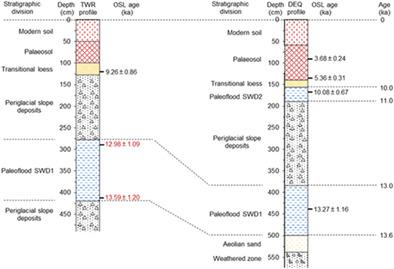
Palaeoflood records have provided the extended perspective required to understand linkages between extreme floods and climate variability. During our palaeo-hydrological investigations, two units of palaeoflood slackwater deposits (SWD) were found on the river banks in the Maqu-Oula reach along the mainstream of the Yellow River on the northeast (NE) Tibetan Plateau. A series of samples were taken from the sediment profiles at Taiwuruo (TWR) and Daerqiong (DEQ) sites for laboratory analysis. Grain-size distribution and micro-morphological characteristics of quartz grains indicate that these well-sorted SWD units were derived from the suspended sediment load in floodwater. They have recorded two episodes of overbank flooding in the Yellow River source area. Using the optically stimulated luminescence (OSL) dating technique, the first episode of overbank flooding was dated to 13.6–13.0 ka and correlated with the Bølling–Allerød warm interval of the last deglaciation. The second episode occurred at 11.0–10.0 ka, that is, the early Holocene. In a warm-humid climate, these overbank flooding episodes may have resulted from the accelerated melting of mountain glaciers and snow over the headwaters of the alpine and subalpine regions on the NE Tibetan Plateau. These results are important in facilitating an in-depth understanding of the hydro-climatic response of the Tibetan Plateau to global climate warming occurring presently.
中文翻译:

青藏高原东北部黄河源区末次冰消期古洪水事件
古洪水记录提供了理解极端洪水与气候变率之间联系所需的扩展视角。在我们的古水文调查中,在青藏高原东北部(NE)黄河干流的玛曲-乌拉河段河岸发现了两套古洪水滞水沉积物(SWD)。从太乌若(TWR)和达尔琼(DEQ)站点的沉积物剖面中采集了一系列样品用于实验室分析。石英颗粒的粒度分布和微观形态特征表明,这些分选良好的 SWD 单元来源于洪水中的悬浮泥沙负荷。他们记录了黄河源区发生的两起河堤泛滥事件。使用光受激发光 (OSL) 测年技术,堤岸洪水的第一次发作可追溯到 13.6-13.0 ka,并与最后一次冰消期的 Bølling-Allerød 暖间隔相关。第二次发作发生在11.0~10.0 ka,即全新世早期。在温暖潮湿的气候中,这些溢洪事件可能是由于青藏高原东北部高山和亚高山地区源头上的山地冰川和积雪加速融化造成的。这些结果对于深入了解青藏高原对当前全球气候变暖的水文气候响应具有重要意义。这些溢洪事件可能是由于青藏高原东北部高山和亚高山地区源头上的山地冰川和积雪加速融化造成的。这些结果对于深入了解青藏高原对当前全球气候变暖的水文气候响应具有重要意义。这些溢洪事件可能是由于青藏高原东北部高山和亚高山地区源头上的山地冰川和积雪加速融化造成的。这些结果对于深入了解青藏高原对当前全球气候变暖的水文气候响应具有重要意义。
更新日期:2021-05-20
中文翻译:
青藏高原东北部黄河源区末次冰消期古洪水事件
古洪水记录提供了理解极端洪水与气候变率之间联系所需的扩展视角。在我们的古水文调查中,在青藏高原东北部(NE)黄河干流的玛曲-乌拉河段河岸发现了两套古洪水滞水沉积物(SWD)。从太乌若(TWR)和达尔琼(DEQ)站点的沉积物剖面中采集了一系列样品用于实验室分析。石英颗粒的粒度分布和微观形态特征表明,这些分选良好的 SWD 单元来源于洪水中的悬浮泥沙负荷。他们记录了黄河源区发生的两起河堤泛滥事件。使用光受激发光 (OSL) 测年技术,堤岸洪水的第一次发作可追溯到 13.6-13.0 ka,并与最后一次冰消期的 Bølling-Allerød 暖间隔相关。第二次发作发生在11.0~10.0 ka,即全新世早期。在温暖潮湿的气候中,这些溢洪事件可能是由于青藏高原东北部高山和亚高山地区源头上的山地冰川和积雪加速融化造成的。这些结果对于深入了解青藏高原对当前全球气候变暖的水文气候响应具有重要意义。这些溢洪事件可能是由于青藏高原东北部高山和亚高山地区源头上的山地冰川和积雪加速融化造成的。这些结果对于深入了解青藏高原对当前全球气候变暖的水文气候响应具有重要意义。这些溢洪事件可能是由于青藏高原东北部高山和亚高山地区源头上的山地冰川和积雪加速融化造成的。这些结果对于深入了解青藏高原对当前全球气候变暖的水文气候响应具有重要意义。


 京公网安备 11010802027423号