Science of the Total Environment ( IF 9.8 ) Pub Date : 2021-05-17 , DOI: 10.1016/j.scitotenv.2021.147710 Ana Oliveira 1 , António Lopes 2 , Ezequiel Correia 2 , Samuel Niza 1 , Amílcar Soares 3
|
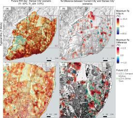
Air temperature is a key aspect of urban environmental health, especially considering population and climate change prospects. While the urban heat island (UHI) effect may aggravate thermal exposure, city-level UHI regression studies are generally restricted to temporal-aggregated intensities (e.g., seasonal), as a function of time-fixed factors (e.g., urban density). Hence, such approaches do not disclose daily urban-rural air temperature changes, such as during heatwaves (HW). Here, summer data from Lisbon’s air temperature urban network (June to September, 2005-2014), is used to develop a linear mixed-effects model (LMM) to predict the daily median and maximum Urban Thermal Signal (UTS) intensities, as a response to the interactions between the time-varying background weather variables (i.e., the regional/non-urban air temperature, 2-hours air temperature change, and wind speed), and time-fixed urban and geographic factors (local climate zones and directional topographic exposure). Results show that, in Lisbon, greatest temperatures and UTS intensities are found in ‘Compact’ areas of the city are proportional to the background air temperature change. In leeward locations, the UTS can be enhanced by the topographic shelter effect, depending on wind speed – i.e., as wind speed augments, the UTS intensity increases in leeward sites, even where sparsely built. The UTS response to a future urban densification scenario, considering climate change HW conditions (RCP8.5, 2081-2100 period), was also assessed, its results showing an UTS increase of circa 1.0°C, in critical areas of the city, despite their upwind location. This LMM empirical approach provides a straightforward tool for local authorities to: (i) identify the short-term critical areas of the city, to prioritise public health measures, especially during HW events; and (ii) test the urban thermal performance, in response to climate change and urban planning scenarios. While the model coefficient estimates are case-specific, the approach can be efficiently replicated in other locations with similar biogeographic conditions.
中文翻译:
一种基于城市气候的经验模型,用于预测城市热信号的当前和未来模式
气温是城市环境健康的一个关键方面,尤其是考虑到人口和气候变化前景。虽然城市热岛 (UHI) 效应可能会加剧热暴露,但城市级 UHI 回归研究通常仅限于时间聚合强度(例如,季节性),作为时间固定因素(例如,城市密度)的函数。因此,此类方法不会披露每日城乡气温变化,例如在热浪 (HW) 期间。在这里,里斯本城市气温网络(2005 年 6 月至 9 月,2014 年 9 月)的夏季数据用于开发线性混合效应模型 (LMM) 来预测每日中值和最大城市热信号 (UTS) 强度,作为对时变背景天气变量(即区域/非城市气温、2 小时气温变化和风速),以及时间固定的城市和地理因素(当地气候带和定向地形暴露)。结果表明,在里斯本,城市“紧凑”地区的最高温度和 UTS 强度与背景气温变化成正比。在背风位置,UTS 可以通过地形遮蔽效应增强,这取决于风速——即,随着风速的增加,背风位置的 UTS 强度增加,即使是在建筑稀疏的地方。考虑到气候变化 HW 条件(RCP8.5,2081-2100 期间),UTS 对未来城市密集化情景的响应也进行了评估,其结果显示,在城市的关键区域,UTS 增加了大约 1.0°C,尽管他们的上风位置。这种 LMM 实证方法为地方当局提供了一个直接的工具:(i) 确定城市的短期关键区域,优先考虑公共卫生措施,尤其是在 HW 事件期间;(ii) 测试城市热性能,以响应气候变化和城市规划情景。虽然模型系数估计是针对特定情况的,但该方法可以在具有类似生物地理条件的其他位置有效地复制。


 京公网安备 11010802027423号