Catena ( IF 6.2 ) Pub Date : 2021-05-15 , DOI: 10.1016/j.catena.2021.105402 Chanchai Petpongpan , Chaiwat Ekkawatpanit , Duangrudee Kositgittiwong
|
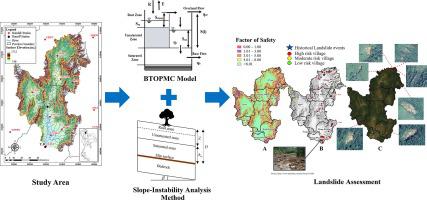
This study applied the Block wise application of TOPMODEL with the Muskingum-Cunge routing method (BTOPMC) for a river runoff simulation and landslide risk assessment in the Upper Yom River Basin. The physical characteristics of the watershed are indicated by concerning the Digital Elevation Model (DEM), land use, and soil types. The hydrological data used for simulation and model performance investigation consist of hourly rainfall intensity and river discharge during the heavy rainfall periods. The consistency between the simulated results and observed data is statistically investigated by Nash-Sutcliffe coefficient of efficiency. The slope failure was analyzed using the slope-instability analysis method with the groundwater level and soil topography index obtained from hydrological simulation. The landslide vulnerable areas are spatially indicated as the area having a Factor of Safety (FS) less than one. The results show that BTOPMC provides a high potential for the hourly simulation of the hydrological regime in the Upper Yom River Basin during high rainfall intensity. In addition, it is revealed that heavy rainfall that happened in studied scenarios cannot cause slope failure. However, several locations show Factor of Safety (FS) values between 1.01 and 3.00, such as the Pong District in Phayao Province, meaning that these areas are vulnerable to landslide events when facing negligible increased precipitation. The analyzed vulnerable landslide areas are similar to those displayed in the landslide risk map presented by the Land Development Department of Thailand. Therefore, this is trustworthy for using in the landslide warnings policy to mitigate the loss of lives and assets.
中文翻译:
使用水文模型对泰国上游尤姆河流域进行滑坡风险评估
这项研究将TOPMODEL与Muskingum-Cunge路由方法(BTOPMC)的块化应用应用于上游Yom河流域的河流径流模拟和滑坡风险评估。流域的物理特征通过涉及数字高程模型(DEM),土地使用和土壤类型来指示。用于模拟和模型性能研究的水文数据包括每小时降雨强度和强降雨期间的河流流量。通过Nash-Sutcliffe效率系数对统计结果与观测数据之间的一致性进行统计研究。使用边坡失稳分析方法对边坡破坏进行了分析,并通过水文模拟获得了地下水位和土壤地形指数。滑坡易损区域在空间上表示为安全系数(FS)小于1的区域。结果表明,BTOPMC具有较高的潜力,可以在高降雨强度下,对上游的尤姆河流域的水文情势进行小时模拟。另外,揭示了在所研究的场景中发生的强降雨不会引起边坡破坏。但是,有几个地点的安全系数(FS)值在1.01到3.00之间,例如拍窑省的Pong区,这意味着这些地区在面对可忽略的增加的降水量时很容易发生滑坡事件。所分析的脆弱滑坡区与泰国土地开发部提供的滑坡风险图上显示的相似。所以,


 京公网安备 11010802027423号