Geomorphology ( IF 3.9 ) Pub Date : 2021-04-23 , DOI: 10.1016/j.geomorph.2021.107755 Cüneyt Güler , Burak Beyhan , Hidayet Tağa
|
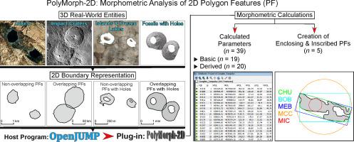
This paper introduces a free and open-source geographic information system (GIS) plug-in, named PolyMorph-2D, for morphometric analysis of vector-based polygon features (PFs) in OpenJUMP. Written in Java™ programming language, the plug-in allows researchers from various earth and spatial science-related disciplines to compute morphometric parameters of 2D input vector features forming a polygon (i.e., a closed curve) which may represent outer boundaries or contours of various natural and/or man-made entities that differ in size, shape, complexity and drawing scale (e.g., craters, sinkholes, cirques, drainage basins, land parcels, buildings, lakes, ponds, peaks, pits, playas, pockmarks, coral mounds, seamounts, landslides, drumlins, islands, atolls, granular materials, mineral crystals, fossils, etc.). Using this plug-in, a number of basic tasks (e.g., calculations related to location, length, width, perimeter, radius, area, and orientation) can be performed and derived parameters (i.e., shape and size measures) of PFs (e.g., axis ratios, ellipticity, circularity, compactness, dispersion, complexity, elongation, regularity, convexity, concavity, solidity, rectangularity, roundness, and sphericity) are computed and written to input polygon layer's attribute table, through a simple point-and-click interface. The derived parameters calculated by the plug-in are invariant to the PF's location, scale (size), and rotation. The plug-in is also capable of performing aforementioned morphometric calculations on overlapping PFs with or without holes, provided they are topologically correct. The extensive data matrix (consisting of 39 parameters) obtained from this route can be further subjected to a number of multivariate statistical analysis methods to decipher underlying processes and/or environmental factors responsible for formation of these shapes and to classify them into homogeneous subtypes or typologies featuring similar characteristics.
中文翻译:
PolyMorph-2D:一个开源GIS插件,用于基于矢量的2D多边形要素的形态计量分析
本文介绍了一个免费的开源地理信息系统(GIS)插件PolyMorph-2D,用于OpenJUMP中基于矢量的多边形要素(PF)的形态分析。该插件使用Java™编程语言编写,允许来自地球和空间科学相关学科的研究人员计算2D输入矢量特征的形态参数,以形成多边形(即闭合曲线),该多边形可以表示各种形状的外部边界或轮廓大小,形状,复杂性和绘制比例不同的天然和/或人造实体(例如,陨石坑,下陷坑,圆盘,流域盆地,地块,建筑物,湖泊,池塘,山峰,坑,海滩,麻子,麻子,珊瑚丘,海山,滑坡,鼓林,岛屿,环礁,颗粒材料,矿物晶体,化石等)。使用此插件,可以执行许多基本任务(例如 例如,可以执行与位置,长度,宽度,周长,半径,面积和方向有关的计算,并导出PF的参数(即形状和尺寸度量)(例如,轴比,椭圆率,圆度,紧密度,分散度)通过简单的点击界面,计算复杂度,伸长率,规则性,凸度,凹度,实体度,矩形度,圆形度和球形度,并将其写入输入多边形层的属性表中。插件计算出的派生参数对于PF的位置,比例(大小)和旋转是不变的。如果拓扑正确,则该插件还可以对有孔或无孔的重叠PF执行上述形态计量计算。


 京公网安备 11010802027423号