当前位置:
X-MOL 学术
›
Earth Surf.Process. Land.
›
论文详情
Our official English website, www.x-mol.net, welcomes your feedback! (Note: you will need to create a separate account there.)
Model prediction capacity of ephemeral gully evolution in conservation tillage systems
Earth Surface Processes and Landforms ( IF 3.3 ) Pub Date : 2021-04-16 , DOI: 10.1002/esp.5134 Eduardo Luquin 1 , Miguel A. Campo‐Bescós 1 , Rafael Muñoz‐Carpena 1, 2 , Ronald L. Bingner 3 , Richard M. Cruse 4 , Henrique G. Momm 5 , Robert R. Wells 3 , Javier Casalí 1
Earth Surface Processes and Landforms ( IF 3.3 ) Pub Date : 2021-04-16 , DOI: 10.1002/esp.5134 Eduardo Luquin 1 , Miguel A. Campo‐Bescós 1 , Rafael Muñoz‐Carpena 1, 2 , Ronald L. Bingner 3 , Richard M. Cruse 4 , Henrique G. Momm 5 , Robert R. Wells 3 , Javier Casalí 1
Affiliation
|
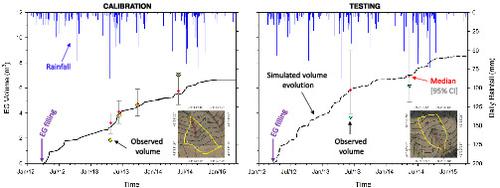
Ephemeral gully (EG) erosion has an important impact on agricultural soil losses and increases field surface hydrology connectivity and transport of pollutants to nearby water bodies. Watershed models including an EG component are scarce and not yet properly evaluated. The objective of this study is to evaluate the capacity of one such tool, AnnAGNPS, to simulate the evolution of two EG formed in a conservation tillage system. The dataset for model testing included runoff measurements and EG morphological characteristics during 3 years. Model evaluation focused on EG evolution of volume, width, and length model outputs, and included calibration and testing phases and a global sensitivity analysis (GSA). While the model did not fully reproduce width and length, the model efficiency to simulate EG volume was satisfactory for both calibration and testing phases, supporting the watershed management objectives of the model. GSA revealed that the most sensitive factors were EG depth, critical shear stress, headcut detachment exponent coefficient b, and headcut detachment leading coefficient a. For EG outputs the model was additive, showing low sensitivity to interactions between the inputs. Prediction of EG spatial evolution on conservation tillage systems requires improved development of gully erosion components, since many of the processes were developed originally for traditional tillage practices or larger channel systems. Our results identify the need for future research when EG form within conservation tillage systems, in particular to study gully headcut, soil erodibility, and width functions specific to these practices.
中文翻译:

保护性耕作系统临时沟壑演化的模型预测能力
短暂的沟壑 (EG) 侵蚀对农业土壤流失具有重要影响,并增加了田间地表水文连通性和污染物向附近水体的传输。包含 EG 组件的流域模型很少,尚未得到适当评估。本研究的目的是评估这样一种工具 AnnAGNPS 模拟保护性耕作系统中形成的两种 EG 演化的能力。模型测试的数据集包括 3 年期间的径流测量和 EG 形态特征。模型评估侧重于体积、宽度和长度模型输出的 EG 演变,包括校准和测试阶段以及全局敏感性分析 (GSA)。虽然模型没有完全重现宽度和长度,模拟 EG 体积的模型效率在校准和测试阶段都令人满意,支持模型的流域管理目标。GSA显示最敏感的因素是EG深度、临界剪切应力、切头脱离指数系数b , 切头脱离超前系数a。对于 EG 输出,该模型是可加的,显示出对输入之间相互作用的低敏感性。保护性耕作系统 EG 空间演化的预测需要改进沟渠侵蚀组件的开发,因为许多过程最初是为传统耕作实践或更大的渠道系统开发的。我们的结果确定了在保护性耕作系统中形成 EG 时进行未来研究的必要性,特别是研究这些实践特有的沟壑断头、土壤可蚀性和宽度函数。
更新日期:2021-04-16
中文翻译:
保护性耕作系统临时沟壑演化的模型预测能力
短暂的沟壑 (EG) 侵蚀对农业土壤流失具有重要影响,并增加了田间地表水文连通性和污染物向附近水体的传输。包含 EG 组件的流域模型很少,尚未得到适当评估。本研究的目的是评估这样一种工具 AnnAGNPS 模拟保护性耕作系统中形成的两种 EG 演化的能力。模型测试的数据集包括 3 年期间的径流测量和 EG 形态特征。模型评估侧重于体积、宽度和长度模型输出的 EG 演变,包括校准和测试阶段以及全局敏感性分析 (GSA)。虽然模型没有完全重现宽度和长度,模拟 EG 体积的模型效率在校准和测试阶段都令人满意,支持模型的流域管理目标。GSA显示最敏感的因素是EG深度、临界剪切应力、切头脱离指数系数b , 切头脱离超前系数a。对于 EG 输出,该模型是可加的,显示出对输入之间相互作用的低敏感性。保护性耕作系统 EG 空间演化的预测需要改进沟渠侵蚀组件的开发,因为许多过程最初是为传统耕作实践或更大的渠道系统开发的。我们的结果确定了在保护性耕作系统中形成 EG 时进行未来研究的必要性,特别是研究这些实践特有的沟壑断头、土壤可蚀性和宽度函数。


 京公网安备 11010802027423号