Geomorphology ( IF 3.9 ) Pub Date : 2021-04-07 , DOI: 10.1016/j.geomorph.2021.107724 A. González-Díez , J.A. Barreda-Argüeso , L. Rodríguez-Rodríguez , J. Fernández-Lozano
|
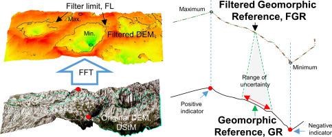
The suitability of Fast Fourier Transform (FFT) filters to delimit the objective location of geomorphic references is analysed for the case of karstic landscapes, where altitudes feature marked differences. From aerial images and a Light Detection and Ranging (LiDAR) derived high-resolution digital elevation model (DEM), a digital database was created, segregating two geomorphic domains according to scale: domain A (macroforms) and domain B (mesoforms), both subdivided in zones of positive and negative relief polarity. In order to minimise the producer error, the correspondence between the DEM morphology and the features mapped was generalised and certified in a test area, reducing ground truth uncertainty. The efficiency of FFT filters was compared against the most commonly referenced in the literature, such as convolution and openness, in terms of computation cost and geometric position. Two types of FFT filters were created modifying the radius of the high pass mask: short radius filters (appropriate to objectivise macroforms); and middle-large radius filters (appropriate for mesoforms) like convolution and openness. The FFT geomorphic reference obtained offers similar geometric patterns to other filters, but reduced computation times. Moreover, the filters reduce the positional uncertainty of geomorphic contacts, without changing the general altitude trend. The generation of FFT filtered references, combining short and middle-large radius, permits objective mapping of karstic landscapes using a DEM.
中文翻译:
基于快速傅里叶变换的滤波器应用于DEM的岩溶特征的客观映射
对于海拔高度明显不同的岩溶景观,分析了快速傅立叶变换(FFT)滤波器确定地貌参考的客观位置的适用性。根据航拍图像和从光探测与测距(LiDAR)导出的高分辨率数字高程模型(DEM),创建了一个数字数据库,根据比例将两个地域划分为两个域:域A(宏形式)和域B(中型),两者分为正浮雕极性和负浮雕极性的区域。为了最大程度地减少生产者误差,在测试区域中对DEM形态与映射特征之间的对应关系进行了概括和验证,从而减少了地面真实性的不确定性。将FFT滤波器的效率与文献中最常见的参考值(例如卷积和开放度)进行了比较,在计算成本和几何位置方面。创建了两种类型的FFT滤波器来修改高通掩码的半径:短半径滤波器(适合于客观化宏格式);和中大半径过滤器(适用于中等形式),例如卷积和开放度。获得的FFT地貌参考提供了与其他滤波器相似的几何图案,但是减少了计算时间。此外,滤波器可以减少地貌接触的位置不确定性,而不会改变总体的海拔趋势。结合短半径和中大半径的FFT滤波参考的生成,允许使用DEM客观地映射岩溶景观。短半径过滤器(适合于客观化宏格式);和中大半径过滤器(适用于中等形式),例如卷积和开放度。获得的FFT地貌参考提供了与其他滤波器相似的几何图案,但是减少了计算时间。此外,滤波器可以减少地貌接触的位置不确定性,而不会改变总体的海拔趋势。结合短半径和中大半径的FFT滤波参考的生成,允许使用DEM客观地映射岩溶景观。短半径过滤器(适合于客观化宏格式);和中大半径过滤器(适用于中等形式),例如卷积和开放度。获得的FFT地貌参考提供了与其他滤波器相似的几何图案,但是减少了计算时间。此外,滤波器可以减少地貌接触的位置不确定性,而不会改变总体的海拔趋势。结合短半径和中大半径的FFT滤波参考的生成,允许使用DEM客观地映射岩溶景观。而不改变总体高度趋势。结合短半径和中大半径的FFT滤波参考的生成,允许使用DEM客观地映射岩溶景观。而不改变总体高度趋势。结合短半径和中大半径的FFT滤波参考的生成,允许使用DEM客观地映射岩溶景观。


 京公网安备 11010802027423号