当前位置:
X-MOL 学术
›
Hydrol. Process.
›
论文详情
Our official English website, www.x-mol.net, welcomes your feedback! (Note: you will need to create a separate account there.)
Fine scale mapping of fractional tree canopy cover to support river basin management
Hydrological Processes ( IF 3.2 ) Pub Date : 2021-04-02 , DOI: 10.1002/hyp.14156 Sicong Gao 1, 2 , Pascal Castellazzi 2, 3 , R. Willem Vervoort 4 , Tanya M. Doody 2
Hydrological Processes ( IF 3.2 ) Pub Date : 2021-04-02 , DOI: 10.1002/hyp.14156 Sicong Gao 1, 2 , Pascal Castellazzi 2, 3 , R. Willem Vervoort 4 , Tanya M. Doody 2
Affiliation
|
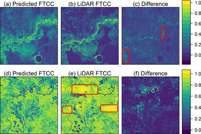
Management of water, regionally, nationally and globally will continue to be a priority and complex undertaking. In riverine systems, biotic components like flora and fauna play critical roles in filtering water so it is available for human use and consumption. Preservation of ecosystems and associated ecosystem functions is therefore vital. In highly regulated large river basins, natural ecosystems are often supported through provision of environmental flows. Flow delivery, however, should be underpinned by rigorous monitoring to identify and prioritise biotic water requirements. Currently, large‐scale monitoring solutions are scaled from remote sensing data via measurement of field evapotranspiration for woody tree vegetation species. However, as there is generally a mismatch between field data collection area and remote sensing pixel size, new methods are required to proportion tree evapotranspiration based on tree fractional canopy area per pixel. We present a novel method to derive tree fractional canopy cover (FTCC) at 20 m resolution in semi‐arid and arid floodplain areas. The method employs LiDAR as a canopy area field measurement proxy (10 m resolution). We used Sentinel‐1 and Sentinel‐2 (radar and multispectral imagery) in a Random Forest analysis, undertaken to develop a predictive FTCC model trained using LiDAR for two regions in the Murray–Darling Basin. A predictor model combining the results of both regions was able to explain between 71%–85% of FTCC variation when compared to LiDAR FTCC when output in 10% increments. Development of this method underpins the advancement of woody vegetation monitoring to inform environmental flow management in the Murray–Darling Basin. The method and fine scale outputs will also be of value to other catchment management concerns such as altered catchment water yields related to bushfires and as such has application to water management worldwide.
中文翻译:

小比例树冠覆盖的精细比例图,以支持流域管理
在区域,国家和全球范围内,水资源管理将继续是一项优先和复杂的工作。在河流系统中,动植物等生物成分在过滤水中起着至关重要的作用,因此可供人类使用和消费。因此,保护生态系统和相关的生态系统功能至关重要。在高度管制的大型流域中,自然生态系统通常通过提供环境流量得到支持。但是,应通过严格的监控来支持流量的发送,以识别生物需水量并确定其优先级。目前,大规模监测解决方案已通过遥感数据通过测量木本树植被物种的田间蒸散量而得到扩展。但是,由于现场数据收集区域和遥感像素大小通常不匹配,需要新的方法来根据每个像素的树冠层面积对树的蒸散量进行比例分配。我们提出了一种在半干旱和干旱洪泛区以20 m的分辨率推导树木分数冠层覆盖量(FTCC)的新方法。该方法采用LiDAR作为树冠区域野外测量代理(分辨率为10 m)。我们在随机森林分析中使用了Sentinel-1和Sentinel-2(雷达图像和多光谱图像),以开发使用LiDAR训练的Murray-Darling盆地中的两个区域的预测FTCC模型。当以10%的增量输出时,与LiDAR FTCC相比,结合两个区域的结果的预测器模型能够解释FTCC变化的71%至85%。这种方法的发展支持了木本植被监测技术的进步,从而为默里-达令盆地的环境流量管理提供了依据。
更新日期:2021-04-19
中文翻译:
小比例树冠覆盖的精细比例图,以支持流域管理
在区域,国家和全球范围内,水资源管理将继续是一项优先和复杂的工作。在河流系统中,动植物等生物成分在过滤水中起着至关重要的作用,因此可供人类使用和消费。因此,保护生态系统和相关的生态系统功能至关重要。在高度管制的大型流域中,自然生态系统通常通过提供环境流量得到支持。但是,应通过严格的监控来支持流量的发送,以识别生物需水量并确定其优先级。目前,大规模监测解决方案已通过遥感数据通过测量木本树植被物种的田间蒸散量而得到扩展。但是,由于现场数据收集区域和遥感像素大小通常不匹配,需要新的方法来根据每个像素的树冠层面积对树的蒸散量进行比例分配。我们提出了一种在半干旱和干旱洪泛区以20 m的分辨率推导树木分数冠层覆盖量(FTCC)的新方法。该方法采用LiDAR作为树冠区域野外测量代理(分辨率为10 m)。我们在随机森林分析中使用了Sentinel-1和Sentinel-2(雷达图像和多光谱图像),以开发使用LiDAR训练的Murray-Darling盆地中的两个区域的预测FTCC模型。当以10%的增量输出时,与LiDAR FTCC相比,结合两个区域的结果的预测器模型能够解释FTCC变化的71%至85%。这种方法的发展支持了木本植被监测技术的进步,从而为默里-达令盆地的环境流量管理提供了依据。


 京公网安备 11010802027423号