当前位置:
X-MOL 学术
›
Remote Sens. Ecol. Conserv.
›
论文详情
Our official English website, www.x-mol.net, welcomes your feedback! (Note: you will need to create a separate account there.)
Characterizing spatial variability in coastal wetland biomass across multiple scales using UAV and satellite imagery
Remote Sensing in Ecology and Conservation ( IF 5.5 ) Pub Date : 2021-03-31 , DOI: 10.1002/rse2.198 Cheryl L. Doughty 1 , Richard F. Ambrose 2 , Gregory S. Okin 1 , Kyle C. Cavanaugh 1
Remote Sensing in Ecology and Conservation ( IF 5.5 ) Pub Date : 2021-03-31 , DOI: 10.1002/rse2.198 Cheryl L. Doughty 1 , Richard F. Ambrose 2 , Gregory S. Okin 1 , Kyle C. Cavanaugh 1
Affiliation
|
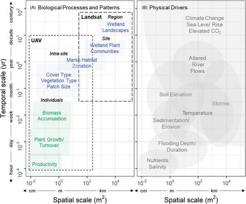
Coastal wetland biomass is an important indicator of wetland productivity, carbon storage, health, and vulnerability to climate change. The ability to estimate aboveground biomass (AGB) in wetlands at ecologically relevant scales is complicated by the spatial variability inherent to patterns in wetland vegetation and the biogeomorphic processes that help create them. Remote sensing provides an approach for mapping wetland biomass, but the spatial resolutions of satellite and airborne imagery often constrain the types of ecological patterns and processes that can be detected. Unmanned Aerial Vehicles (UAVs) have previously been used to capture fine-scale (≤1 m) variability in AGB in coastal wetland settings. However, it remains unclear if a UAV approach to estimating wetland biomass is transferrable across diverse wetland sites or how it compares to commonly used satellite-based approaches. Here, we test the capabilities of UAVs in remotely quantifying AGB and compare biomass estimation using UAV and Landsat satellite imagery (30 m resolution) in several wetland sites in Southern California. Field surveys highlight significant spatial variability in wetland plant community AGB and height that influence remote biomass estimation. Relationships between UAV vegetation indices and AGB were site-specific and influenced by vegetation types. Biomass estimation using UAVs (r2 = 0.40, RMSE = 534.6 g m−2) showed better correlation with NDVI than a Landsat-based approach (r2 = 0.26, RMSE = 596.8 g m−2). We found combining high-resolution UAV AGB maps and Landsat NDVI to develop AGB models showed the highest correlation (r2 = 0.45, RMSE = 659.7 g m−2) and provided additional spatial information to aid scaling field data to satellite imagery. Overall, UAVs captured more spatial complexity in aboveground biomass at finer scales than is possible with moderate-resolution Landsat pixels, indicating that UAVs can be used to characterize patterns of within-marsh variability resulting from local-scale (≤ 100s of meters) ecological processes.
中文翻译:

使用无人机和卫星图像在多个尺度上表征沿海湿地生物量的空间变异性
沿海湿地生物量是湿地生产力、碳储存、健康和气候变化脆弱性的重要指标。在生态相关尺度上估算湿地地上生物量 (AGB) 的能力因湿地植被模式固有的空间变异性和帮助创建它们的生物地貌过程而变得复杂。遥感为绘制湿地生物量提供了一种方法,但卫星和机载图像的空间分辨率通常限制了可以检测到的生态模式和过程的类型。无人机 (UAV) 以前曾被用于捕捉沿海湿地环境中 AGB 的精细尺度 (≤1 m) 变化。然而,目前尚不清楚用于估计湿地生物量的无人机方法是否可以在不同的湿地地点之间转移,或者与常用的基于卫星的方法相比如何。在这里,我们测试了无人机远程量化 AGB 的能力,并在南加州的几个湿地地点使用无人机和 Landsat 卫星图像(30 m 分辨率)比较了生物量估计。实地调查突出了影响远程生物量估计的湿地植物群落 AGB 和高度的显着空间变异性。无人机植被指数与 AGB 之间的关系是特定地点的,并受植被类型的影响。使用无人机的生物量估计(我们测试了无人机远程量化 AGB 的能力,并在南加州的几个湿地地点使用无人机和 Landsat 卫星图像(30 m 分辨率)比较了生物量估计。实地调查突出了影响远程生物量估计的湿地植物群落 AGB 和高度的显着空间变异性。无人机植被指数与 AGB 之间的关系是特定地点的,并受植被类型的影响。使用无人机的生物量估计(我们测试了无人机远程量化 AGB 的能力,并在南加州的几个湿地地点使用无人机和 Landsat 卫星图像(30 m 分辨率)比较了生物量估计。实地调查突出了影响远程生物量估计的湿地植物群落 AGB 和高度的显着空间变异性。无人机植被指数与 AGB 之间的关系是特定地点的,并受植被类型的影响。使用无人机的生物量估计(r 2 = 0.40, RMSE = 534.6 g m -2 ) 与基于 Landsat 的方法 ( r 2 = 0.26, RMSE = 596.8 g m -2 )显示出与 NDVI 更好的相关性。我们发现结合高分辨率无人机 AGB 地图和 Landsat NDVI 来开发 AGB 模型显示出最高的相关性 ( r 2 = 0.45, RMSE = 659.7 g m -2) 并提供额外的空间信息以帮助将现场数据缩放到卫星图像。总体而言,与中等分辨率 Landsat 像素相比,无人机在更精细的尺度上捕获了更多的地上生物量空间复杂性,这表明无人机可用于表征由局部尺度(≤ 100 米)生态过程引起的沼泽内变异模式.
更新日期:2021-03-31
中文翻译:
使用无人机和卫星图像在多个尺度上表征沿海湿地生物量的空间变异性
沿海湿地生物量是湿地生产力、碳储存、健康和气候变化脆弱性的重要指标。在生态相关尺度上估算湿地地上生物量 (AGB) 的能力因湿地植被模式固有的空间变异性和帮助创建它们的生物地貌过程而变得复杂。遥感为绘制湿地生物量提供了一种方法,但卫星和机载图像的空间分辨率通常限制了可以检测到的生态模式和过程的类型。无人机 (UAV) 以前曾被用于捕捉沿海湿地环境中 AGB 的精细尺度 (≤1 m) 变化。然而,目前尚不清楚用于估计湿地生物量的无人机方法是否可以在不同的湿地地点之间转移,或者与常用的基于卫星的方法相比如何。在这里,我们测试了无人机远程量化 AGB 的能力,并在南加州的几个湿地地点使用无人机和 Landsat 卫星图像(30 m 分辨率)比较了生物量估计。实地调查突出了影响远程生物量估计的湿地植物群落 AGB 和高度的显着空间变异性。无人机植被指数与 AGB 之间的关系是特定地点的,并受植被类型的影响。使用无人机的生物量估计(我们测试了无人机远程量化 AGB 的能力,并在南加州的几个湿地地点使用无人机和 Landsat 卫星图像(30 m 分辨率)比较了生物量估计。实地调查突出了影响远程生物量估计的湿地植物群落 AGB 和高度的显着空间变异性。无人机植被指数与 AGB 之间的关系是特定地点的,并受植被类型的影响。使用无人机的生物量估计(我们测试了无人机远程量化 AGB 的能力,并在南加州的几个湿地地点使用无人机和 Landsat 卫星图像(30 m 分辨率)比较了生物量估计。实地调查突出了影响远程生物量估计的湿地植物群落 AGB 和高度的显着空间变异性。无人机植被指数与 AGB 之间的关系是特定地点的,并受植被类型的影响。使用无人机的生物量估计(r 2 = 0.40, RMSE = 534.6 g m -2 ) 与基于 Landsat 的方法 ( r 2 = 0.26, RMSE = 596.8 g m -2 )显示出与 NDVI 更好的相关性。我们发现结合高分辨率无人机 AGB 地图和 Landsat NDVI 来开发 AGB 模型显示出最高的相关性 ( r 2 = 0.45, RMSE = 659.7 g m -2) 并提供额外的空间信息以帮助将现场数据缩放到卫星图像。总体而言,与中等分辨率 Landsat 像素相比,无人机在更精细的尺度上捕获了更多的地上生物量空间复杂性,这表明无人机可用于表征由局部尺度(≤ 100 米)生态过程引起的沼泽内变异模式.


 京公网安备 11010802027423号