Progress in Earth and Planetary Science ( IF 3.9 ) Pub Date : 2021-03-26 , DOI: 10.1186/s40645-021-00419-6 Haruka Tsunetaka , Slim Mtibaa , Shiho Asano , Takashi Okamoto , Ushio Kurokawa
|
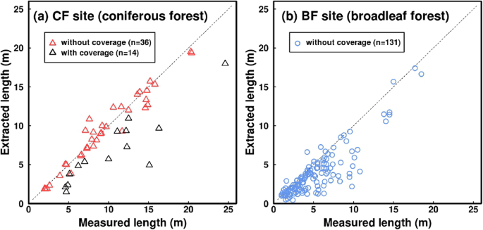
As wood pieces supplied by landslides and debris flows are one of the main components of ecological and geomorphic systems, the importance of quantifying the dimensions of the wood pieces is evident. However, the low accessibility of disturbed channels after debris flows generally impedes accurate and quick wood-piece investigations. Thus, remote-sensing measurements for wood pieces are necessitated. Focusing on sub-watersheds in coniferous and broadleaf forests in Japan (the CF and BF sites, respectively), we measured the lengths of wood pieces supplied by landslides (> 0.2 m length and > 0.03 m diameter) from orthophotos acquired using a small unmanned aerial vehicle (UAV). The measurement accuracy was analyzed by comparing the lengths derived from the UAV method with direct measurements. The landslides at the CF and BF sites were triggered by extremely heavy rainfalls in 2017 and 2018, respectively. UAV flights were operated during February and September 2019 at the CF site and during November 2018 and December 2019 at the BF site. Direct measurements of wood pieces were carried out on the date of the respective second flight date in each site. When both ends of a wood piece are satisfactorily extracted from an orthophoto acquired by the UAV, the wood-piece lengths at the CF site can be measured with an accuracy of approximately ±0.5 m. At the BF site, most of the extracted lengths were shorter than the directly measured lengths, probably because the complex structures of the root wad and tree crown reduced the visibility. Most wood pieces were discharged from landslide scars at the BF site, but at the CF site, approximately 750 wood pieces remained in the landslide scars approximately 19 months after the landslide occurrence. The number of wood pieces in the landslide scars of the CF site increased with increasing landslide area, suggesting that some wood pieces can be left even if large landslides occur. The lengths and locations of the entrapped wood pieces at both sites were not significantly changed between the two UAV flight dates. However, during this period, the rainfall intensities around the CF site measured by the closest rain-gauge of the Japan Meteorological Agency reached their second highest values from 1976 to 2019, which exceeded the 30-year return period. This suggests that most of the entrapped wood pieces rarely migrated even under intense rainfall.
中文翻译:
使用无人飞行器获取的正射影像绘制的针叶林和阔叶林覆盖的溪流中木片的长度和动力学比较
由于由滑坡和泥石流供应的木片是生态和地貌系统的主要组成部分之一,因此量化木片尺寸的重要性显而易见。然而,泥石流之后受干扰的通道的可及性较低,这通常会妨碍对木片的准确,快速的调查。因此,需要对木材进行遥感测量。着眼于日本针叶林和阔叶林的分水岭(分别为CF和BF地点),我们测量了由滑坡提供的木片的长度(长度> 0.2 m,直径> 0.03 m),这些图像来自使用少量无人获取的正射影像飞机(UAV)。通过将UAV方法得出的长度与直接测量值进行比较,分析了测量精度。CF和BF站点的滑坡分别是2017年和2018年的特大降雨触发的。无人机飞行于2019年2月和2019年9月在CF基地运营,2018年11月和2019年12月在BF基地运营。在每个站点的相应第二次飞行日期,对木片进行了直接测量。当从无人机获取的正射影像中令人满意地提取木片的两端时,可以以大约±0.5 m的精度测量CF部位的木片长度。在高炉部位,大多数提取长度都比直接测量的长度短,这可能是因为根团和树冠的复杂结构降低了可见度。大多数木材碎片是在BF现场从滑坡疤痕中排出的,但在CF现场,滑坡发生后约19个月,滑坡疤痕中仍有约750个木片。CF部位滑坡疤痕中的木片数量随滑坡面积的增加而增加,这表明即使发生大的滑坡,也可以留下一些木片。在两个无人机飞行日期之间,两个地点的被困木片的长度和位置都没有显着变化。然而,在此期间,由日本气象厅最近的雨量计测得的CF站周围的降雨强度从1976年至2019年达到第二高值,超过了30年的回归期。这表明即使在强降雨条件下,大多数被包裹的木片也很少迁移。


 京公网安备 11010802027423号