Earth, Planets and Space ( IF 3.362 ) Pub Date : 2021-03-19 , DOI: 10.1186/s40623-021-01395-3 Hideaki Goto
|
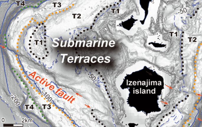
Late Quaternary tectonic deformation of coastal areas is usually examined based on the height distribution of paleo-shorelines observed on marine terraces. However, it is difficult to examine deformation along the subduction zone, in which small, isolated islands are distributed. In this paper, the author focuses on the widespread shallow submarine terraces surrounding the Iheya–Izena islands in the middle part of the Nanseishoto Islands, Southwest Japan, where crustal deformation is not known. The islands are located in the intermediate zone between island shelf uplifted during the Late Quaternary and the rift zone occurred to the northwest, along the Okinawa trough. Detailed topographic anaglyph images and maps of the islands were produced using a digital elevation model (DEM) of the seafloor, which is stored by the Japan Coast Guard (JCG) and the Advanced Institute of Science and Technology (AIST). Topographic anaglyph images enabled us to identify the widespread distribution and deformation of the shallow seafloor above − 200 m using red–cyan glasses. Four terrace-like features divided by small steps were found on the shallow seafloor, which are named T1, T2, T3, and T4, in descending order. Topographic expressions of paleo-shoreline depths are preserved on submarine terraces formed during the last glacial period. The paleo-shoreline depths of terraces T2 and T3 are − 60 m and − 70 m on the west side and − 70 m and − 80 m, respectively, on the east side of Iheyajima Island; this indicates southeastward tilting. The tilting ratio of T2 and T3 was calculated to approximately 1‰. The tilting rate is approximately 1 × 10⁻⁴/kyr, assuming that the T2 was formed in 10–11 kyr. This is much more rapid than that of the last inter-glacial marine terraces in the Muroto peninsula of Shikoku, Japan, with a tilting rate of 4 × 10⁻⁵/kyr, which formed by steep northward tilting against the Nankai subduction zone. The author suggests that this phenomenon is not related to mega-thrusting along the subduction zone, but rather to local deformation, probably caused by the reverse faulting of nearby active submarine faults along the west side of the islands.
中文翻译:
海底阶地揭示了日本西南部南正统群岛中部岛架与裂谷带之间的中间区域的第四纪晚期构造变形。
通常根据在海洋阶地上观测到的古海岸线的高度分布来检查沿海地区的第四纪晚期构造变形。但是,很难检查沿俯冲带的变形情况,在该俯冲带中分布着小的孤立岛。在本文中,作者着重研究了日本西南部南正市群岛中部的伊希亚-伊泽纳群岛周围广泛分布的浅海海底阶地,该地壳的形变尚不为人所知。这些岛屿位于第四纪末期隆起的岛架与沿冲绳海槽发生在西北的裂谷带之间的中间区域。使用海底的数字高程模型(DEM)制作了详细的地形浮雕图像和岛屿地图,由日本海岸警卫队(JCG)和高级科学技术研究所(AIST)存储。地形浮雕图像使我们能够使用红蓝玻璃识别200 m以上的浅海底的广泛分布和变形。在浅海海底发现了四个由小台阶划分的类似梯田的特征,按降序分别命名为T1,T2,T3和T4。古海岸线深度的地形表达保留在最后一个冰川期形成的海底阶地上。T2和T3阶地的古海岸线深度在西边岛分别为-60 m和-70 m,在伊势矢岛岛的东边分别为-70 m和-80 m;这表明向东南倾斜。计算出T2和T3的倾斜比约为1‰。倾斜率约为1×10 地形浮雕图像使我们能够使用红蓝玻璃识别200 m以上的浅海底的广泛分布和变形。在浅海底面上发现了四个由梯级划分的阶梯状特征,按降序排列分别为T1,T2,T3和T4。古海岸线深度的地形表达保留在最后一个冰川期形成的海底阶地上。梯田T2和T3的古海岸线深度在西边岛分别为− 60 m和− 70 m,在石垣岛东边分别为− 70 m和− 80 m;这表明向东南倾斜。计算出T2和T3的倾斜比约为1‰。倾斜率约为1×10 地形浮雕图像使我们能够使用红蓝玻璃识别200 m以上的浅海底的广泛分布和变形。在浅海底面上发现了四个由梯级划分的阶梯状特征,按降序排列分别为T1,T2,T3和T4。古海岸线深度的地形表达保留在最后一个冰川期形成的海底阶地上。梯田T2和T3的古海岸线深度在西边岛分别为− 60 m和− 70 m,在石垣岛东边分别为− 70 m和− 80 m;这表明向东南倾斜。计算出T2和T3的倾斜比约为1‰。倾斜率约为1×10 在浅海底面上发现了四个由梯级划分的阶梯状特征,按降序排列分别为T1,T2,T3和T4。古海岸线深度的地形表达保留在最后一个冰川期形成的海底阶地上。梯田T2和T3的古海岸线深度在西边岛分别为− 60 m和− 70 m,在石垣岛东边分别为− 70 m和− 80 m;这表明向东南倾斜。计算出T2和T3的倾斜比约为1‰。倾斜率约为1×10 在浅海底面上发现了四个由梯级划分的阶梯状特征,按降序排列分别为T1,T2,T3和T4。古海岸线深度的地形表达保留在最后一个冰川期形成的海底阶地上。梯田T2和T3的古海岸线深度在西边岛分别为− 60 m和− 70 m,在石垣岛东边分别为− 70 m和− 80 m;这表明向东南倾斜。计算出T2和T3的倾斜比约为1‰。倾斜率约为1×10 梯田T2和T3的古海岸线深度在西边岛分别为− 60 m和− 70 m,在石垣岛东边分别为− 70 m和− 80 m;这表明向东南倾斜。计算出T2和T3的倾斜比约为1‰。倾斜率约为1×10 梯田T2和T3的古海岸线深度在西边岛分别为− 60 m和− 70 m,在石垣岛东边分别为− 70 m和− 80 m;这表明向东南倾斜。计算出T2和T3的倾斜比约为1‰。倾斜率约为1×10⁻⁴ / kyr,假设T2是在10-11年间形成的。这比日本四国室户半岛最后的冰川间海洋阶地要快得多,后者的倾斜速率为4×10 –5 / kyr,这是由南向俯冲带向北倾斜而形成的。作者认为,这种现象与沿俯冲带的大推力无关,而与局部变形有关,这可能是由岛屿西侧附近的活跃海底断层的反向断层引起的。


 京公网安备 11010802027423号