Science of the Total Environment ( IF 9.8 ) Pub Date : 2021-02-24 , DOI: 10.1016/j.scitotenv.2021.146051 Ting Zhang , Bo Tian , Yujue Wang , Dongyan Liu , Saisai Sun , Yuanqiang Duan , Yunxuan Zhou
|
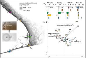
Quantifying temporal and spatial changes in microphytobenthos (MPB) biomass is critical for understanding its ecological function in estuarine food web networks and carbon flows. However, tidal fluctuations and the complex composition of coastal sediment limit remote sensing applications for estimating MPB biomass seasonal variations in estuarine tidal flats. We integrated radar Sentinel-1 (S1) and optical Sentinel-2 (S2) remote sensing data to quantify the temporal and spatial variability in MPB biomass in the Changjiang estuary, China. Pixels of water bodies on the tidal flats were removed by dynamic threshold segmentation of the water index with the combined S1 and S2 data, and salt marsh pixels were masked with the first red-edge band in the S2 data. We used the continuum-removed spectral absorption depth feature to construct a regression model for estimating MPB biomass with a regression coefficient of 0.81. The results showed that spectral absorption continuum removal methods using broadband multispectral data for MPB estimation are a promising alternative to hyperspectral narrowband ratio operation. Compared with the widely used normalized difference vegetation index (NDVI), the scaled absorption depth feature was more stable for MPB estimation under a changeable sediment background. The produced seasonal map showed that the high biomass levels of the MPB in the study area are not limited to one season and one site, with an annual mean biomass of 14.39 mg chlorophyll a (Chl-a)·m−2 and 71% confirmed accuracy. The highest biomass levels occurred in summer in the supratidal zone (19.51 mg Chl-a·m−2) and in spring in the intertidal zone (17.10 mg Chl-a·m−2) in the Changjiang estuary. The relative shore height, derived from the tidal range here, is an important variable that shapes the MPB spatial distribution. This study demonstrates the potential of integrating high-spatial-resolution (10 m) S1 and S2 data for future large-scale estimation of intertidal MPB.


 京公网安备 11010802027423号