Journal of Environmental Radioactivity ( IF 2.3 ) Pub Date : 2021-02-16 , DOI: 10.1016/j.jenvrad.2021.106545 S. van der Veeke , J. Limburg , R.L. Koomans , M. Söderström , S.N. de Waal , E.R. van der Graaf
|
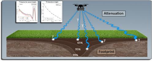
Advancements in the development of gamma-ray spectrometers (GRS) have led to small and lightweight spectrometers that can be used under unmanned aerial vehicles (UAVs). Airborne GRS measurements are used to determine radionuclide concentrations in the ground, among which the natural occurring radionuclides 40K, 238U, and 232Th. For successful applications of these GRS sensors, it is important that absolute values of concentrations can be measured. To extract these absolute radionuclide concentrations, airborne gamma-ray data has to be corrected for measurement height. However, the current analysis models are only valid for the height range of 50–250 m. The purpose of this study is to develop a procedure that correctly predicts the true radionuclide concentration in the ground when measuring in the UAV operating range of 0–40 m. An analytical model is developed to predict the radiation footprint as a function of height. This model is used as a tool to properly determine a source-detector geometry to be used in Monte-Carlo simulations of detector response at various elevations between 0 and 40 m. The analytical model predicts that the smallest achievable footprint at 10 m height lies between 22 and 91 m and between 40 and 140 m at 20 m height. By using Monte-Carlo simulations it is shown that the analytical model correctly predicts the reduction in full energy peak gamma-rays, but does not predict the Compton continuum of a spectrum as a function of height. Therefore, Monte-Carlo simulations should be used to predict the shape and intensity of gamma-ray spectra as a function of height. A finite set of Monte-Carlo simulations at intervals of 5 m were used for the analysis of GRS measurements at heights up to 35 m. The resulting radionuclide concentrations at every height agree with the radionuclide concentration measured on the ground.
中文翻译:
无人机传播的伽马射线光谱研究的足迹和高度校正
伽马射线光谱仪(GRS)的发展进步导致了小型轻巧的光谱仪可用于无人机(UAV)。机载GRS测量用于确定地面中的放射性核素浓度,其中天然存在的放射性核素40 K,238 U和232。对于这些GRS传感器的成功应用,重要的是可以测量浓度的绝对值。要提取这些绝对的放射性核素浓度,必须对机载伽马射线数据进行测量高度校正。但是,当前的分析模型仅适用于50-250 m的高度范围。这项研究的目的是开发一种程序,以在0-40 m的无人飞行器工作范围内进行测量时正确预测地面中的真实放射性核素浓度。开发了一个分析模型来预测辐射足迹随高度的变化。该模型用作适当确定在0至40 m之间各种高度的探测器响应的蒙特卡罗模拟中使用的源探测器几何形状的工具。分析模型预测,在10 m高度处可实现的最小足迹在22 m至91 m之间以及20 m处40至140 m之间。通过使用蒙特卡洛模拟,可以证明分析模型正确地预测了全能峰伽马射线的减少,但没有预测光谱的康普顿连续体随高度的变化。因此,应使用蒙特卡洛模拟来预测伽马射线谱的形状和强度与高度的关系。间隔为5 m的一组有限的蒙特卡洛模拟用于分析高度高达35 m的GRS测量。在每个高度得到的放射性核素浓度与在地面上测得的放射性核素浓度一致。通过使用蒙特卡洛模拟,可以证明分析模型可以正确预测全能峰伽马射线的减少,但不能预测光谱的康普顿连续体随高度的变化。因此,应使用蒙特卡洛模拟来预测伽马射线谱的形状和强度与高度的关系。间隔为5 m的一组有限的蒙特卡洛模拟用于分析高度高达35 m的GRS测量。在每个高度得到的放射性核素浓度与在地面上测得的放射性核素浓度一致。通过使用蒙特卡洛模拟,可以证明分析模型正确地预测了全能峰伽马射线的减少,但没有预测光谱的康普顿连续体随高度的变化。因此,应使用蒙特卡洛模拟来预测伽马射线谱的形状和强度与高度的关系。间隔为5 m的一组有限的蒙特卡洛模拟用于分析高度高达35 m的GRS测量。在每个高度得到的放射性核素浓度与在地面上测得的放射性核素浓度一致。应该使用蒙特卡洛模拟来预测伽马射线光谱的形状和强度与高度的关系。间隔为5 m的一组有限的蒙特卡洛模拟用于分析高度高达35 m的GRS测量。在每个高度得到的放射性核素浓度与在地面上测得的放射性核素浓度一致。应该使用蒙特卡洛模拟来预测伽马射线光谱的形状和强度与高度的关系。间隔为5 m的一组有限的蒙特卡洛模拟用于分析高度高达35 m的GRS测量。在每个高度得到的放射性核素浓度与在地面上测得的放射性核素浓度一致。


 京公网安备 11010802027423号