Computers & Graphics ( IF 2.5 ) Pub Date : 2021-02-13 , DOI: 10.1016/j.cag.2021.02.003 Shi Li , Chuankun Zheng , Rui Wang , Yuchi Huo , Wenting Zheng , Hai Lin , Hujun Bao
|
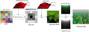
Due to the fundamental weaknesses of level-of-detail (LOD) control and rich details in the Geometry Clipmaps, we propose a multi-resolution terrain rendering algorithm that utilizes summed-area tables (SATs) [1] to facilitate the rendering of terrain with better geometric and shading details. First, our algorithm introduces a novel geometric error bound on the screen-based terrain rendering approach that juggles low rendering throughput and better LOD control. Geometric errors are estimated in real-time from SATs, enabling error-bounded geometry clipmap. Second, we utilize Spherical Gaussian (SG) functions to approximate lighting and bidirectional reflection distribution functions (BRDFs), and efficiently calculate outgoing radiance with self-occlusions of the terrain. SATs are utilized to enable the mipmapping of visibility and normal maps. We demonstrate the improvements of our method with experiments on accuracy and efficiency.
中文翻译:
使用求和面积表进行多分辨率地形渲染
由于详细程度(LOD)控制的基本弱点和“几何剪贴图”中的丰富细节,我们提出了一种多分辨率地形渲染算法,该算法利用求和面积表(SAT)[1]来简化地形渲染具有更好的几何和底纹细节。首先,我们的算法在基于屏幕的地形渲染方法上引入了一种新颖的几何误差,可以解决低渲染吞吐量和更好的LOD控制的问题。可通过SAT实时估算几何误差,从而实现误差范围有限的几何剪贴图。其次,我们利用球面高斯(SG)函数来近似照明和双向反射分布函数(BRDF),并有效地计算出具有自遮蔽地形的辐射。SAT用于实现可视性和法线贴图的映射。


 京公网安备 11010802027423号