Digital Applications in Archaeology and Cultural Heritage Pub Date : 2021-02-02 , DOI: 10.1016/j.daach.2021.e00172 Mikhail V. Vavulin , Konstantin V. Chugunov , Olga V. Zaitceva , Evgeny V. Vodyasov , Andrei A. Pushkarev
|
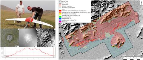
The article offers an evaluation of the adequacy and effectiveness of using UAV-based photogrammetry for updating the planigraphy of well-studied archaeological sites and discovering new ones. The study is based on the data collected in the ‘Valley of the Kings’ in the Republic of Tyva (otherwise called Tuva, Russia). Data analysis using GIS software found 1000 archaeological objects and other, possibly archaeological objects. UAV-based digital photogrammetry has proved informative and effective in our study. In addition to the previously known archaeological objects, it enabled us to detect numerous new archaeological objects, which had been missed in the earlier investigations carried out on the ground. However, this survey technology has been found to have a significant number of limitations as to its applicability in the search for archaeological objects, and it is concluded that UAVs cannot replace archaeological investigations on the ground, particularly as regards identification of objects.
中文翻译:
基于无人机的摄影测量:评估“国王谷”(俄罗斯图瓦)在考古监测和调查中的应用潜力和有效性
本文评估了使用基于无人机的摄影测量技术来更新经过充分研究的考古遗址的平面图并发现新遗址的充分性和有效性。该研究基于在蒂瓦共和国(也称为俄罗斯图瓦)的“国王之谷”中收集的数据。使用GIS软件进行的数据分析发现了1000个考古对象以及其他可能的考古对象。在我们的研究中,基于无人机的数字摄影测量已被证明是有益的和有效的。除了以前已知的考古对象外,它还使我们能够检测到许多新的考古对象,而这些新的考古对象在早期进行的地面研究中却被遗漏了。然而,


 京公网安备 11010802027423号