当前位置:
X-MOL 学术
›
Earth Surf.Process. Land.
›
论文详情
Our official English website, www.x-mol.net, welcomes your feedback! (Note: you will need to create a separate account there.)
Mapping mineralogy in evaporite basins through time using multispectral Landsat data: Examples from the Bonneville basin, Utah, USA
Earth Surface Processes and Landforms ( IF 3.3 ) Pub Date : 2021-02-01 , DOI: 10.1002/esp.5089 Mark H. Radwin 1 , Brenda B. Bowen 1, 2
Earth Surface Processes and Landforms ( IF 3.3 ) Pub Date : 2021-02-01 , DOI: 10.1002/esp.5089 Mark H. Radwin 1 , Brenda B. Bowen 1, 2
Affiliation
|
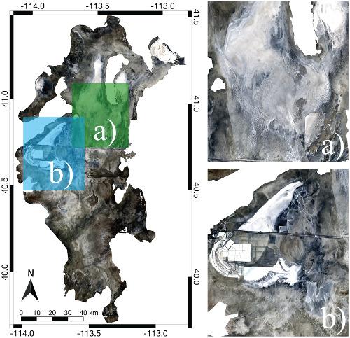
The Bonneville basin, located in north-western Utah, is a vast evaporite basin which is home to the world-renowned Bonneville Salt Flats international speedway and is a highly valued landscape undergoing rapid change and anthropogenic influence. Air quality, snowpack, the local hydrological system, and state tourism are all impacted by the nature of the surface sediments exposed in the Bonneville basin. Mapping the Bonneville basin over time with remote sensing methods provides insight into the dynamics and impacts of the changing surface landscape. Utilizing the Landsat-5 Thematic Mapper (TM) and Landsat-8 Operational Land Imager (OLI) sensors, a set of band math indices are empirically established to map the predominant halite, gypsum, and carbonates mineralogical zones of the Bonneville basin. Spectral comparisons of representative samples from the study area and image-derived spectra indicate the halite of the Bonneville basin is wet and that gypsum deposits are slightly mixed with halite. The established indices are assessed in four ways, all of which support the ability of the indices to accentuate the associated mineralogical endmembers. Two study areas within the Bonneville basin are investigated temporally from 1986, 1995, 2005, and 2016 and show changing patterns in mineral distribution that align with surface processes active through these timescales. These indices provide a resource for mapping mineralogy though time in evaporite basins globally with diverse applications for questions about land use and environmental change.
中文翻译:

使用多光谱Landsat数据绘制蒸发岩盆地中矿物学的时间分布图:来自美国犹他州邦纳维尔盆地的实例
位于犹他州西北部的邦纳维尔盆地是一个巨大的蒸发岩盆地,这里是举世闻名的邦纳维尔盐沼国际赛车场的所在地,并且是受到快速变化和人为影响的极具价值的景观。空气质量,积雪,当地水文系统和国家旅游都受到邦纳维尔盆地暴露的地表沉积物性质的影响。使用遥感方法随时间推移绘制邦纳维尔盆地的地图,可以深入了解不断变化的地表景观的动态变化和影响。利用Landsat-5专题测绘仪(TM)和Landsat-8操作性陆地成像仪(OLI)传感器,凭经验建立了一组波段数学指标,以绘制Bonneville盆地的主要盐岩,石膏和碳酸盐岩矿物学区域。来自研究区域的代表性样品的光谱比较和图像得出的光谱表明,邦纳维尔盆地的岩盐是湿的,并且石膏沉积物与岩盐略有混合。已建立的指数以四种方式进行评估,所有这些方式都支持该指数突显相关矿物学端元的能力。从1986年,1995年,2005年和2016年对Bonneville盆地内的两个研究区域进行了时间调查,结果显示矿物分布的变化模式与在这些时间尺度上活跃的地表过程相吻合。这些指数提供了一个资源图,用于绘制全球蒸发岩盆地中时间的矿物学图,并针对土地利用和环境变化提出了各种不同的应用。
更新日期:2021-02-01
中文翻译:
使用多光谱Landsat数据绘制蒸发岩盆地中矿物学的时间分布图:来自美国犹他州邦纳维尔盆地的实例
位于犹他州西北部的邦纳维尔盆地是一个巨大的蒸发岩盆地,这里是举世闻名的邦纳维尔盐沼国际赛车场的所在地,并且是受到快速变化和人为影响的极具价值的景观。空气质量,积雪,当地水文系统和国家旅游都受到邦纳维尔盆地暴露的地表沉积物性质的影响。使用遥感方法随时间推移绘制邦纳维尔盆地的地图,可以深入了解不断变化的地表景观的动态变化和影响。利用Landsat-5专题测绘仪(TM)和Landsat-8操作性陆地成像仪(OLI)传感器,凭经验建立了一组波段数学指标,以绘制Bonneville盆地的主要盐岩,石膏和碳酸盐岩矿物学区域。来自研究区域的代表性样品的光谱比较和图像得出的光谱表明,邦纳维尔盆地的岩盐是湿的,并且石膏沉积物与岩盐略有混合。已建立的指数以四种方式进行评估,所有这些方式都支持该指数突显相关矿物学端元的能力。从1986年,1995年,2005年和2016年对Bonneville盆地内的两个研究区域进行了时间调查,结果显示矿物分布的变化模式与在这些时间尺度上活跃的地表过程相吻合。这些指数提供了一个资源图,用于绘制全球蒸发岩盆地中时间的矿物学图,并针对土地利用和环境变化提出了各种不同的应用。


 京公网安备 11010802027423号