当前位置:
X-MOL 学术
›
Remote Sens. Ecol. Conserv.
›
论文详情
Our official English website, www.x-mol.net, welcomes your feedback! (Note: you will need to create a separate account there.)
Extending deep learning approaches for forest disturbance segmentation on very high-resolution satellite images
Remote Sensing in Ecology and Conservation ( IF 5.5 ) Pub Date : 2021-01-26 , DOI: 10.1002/rse2.194 Dmitry E. Kislov 1 , Kirill A. Korznikov 1 , Jan Altman 2 , Anna S. Vozmishcheva 1, 3 , Pavel V. Krestov 1
Remote Sensing in Ecology and Conservation ( IF 5.5 ) Pub Date : 2021-01-26 , DOI: 10.1002/rse2.194 Dmitry E. Kislov 1 , Kirill A. Korznikov 1 , Jan Altman 2 , Anna S. Vozmishcheva 1, 3 , Pavel V. Krestov 1
Affiliation
|
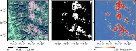
Accurate remote detection of various forest disturbances is a challenge in global environmental monitoring. Addressing this issue is crucial for forest health assessment, planning salvage logging operations, modeling stand dynamics, and estimating forest carbon stocks and uptake. Substantial progress on this problem has been achieved owing to the rapid development of remote sensing devices that provide very high-resolution images. Concurrently, image processing algorithms have witnessed rapid development owing to the extensive use of artificial neural networks with complex architectures and deep learning approaches. This opens new opportunities and perspectives for applying deep learning methods to solving various problems in environmental sciences. In this study, we used deep convolutional neural networks (DCNNs) to recognize forest damage induced by windthrows and bark beetles. We used satellite imagery of very high resolution in visual spectra represented as pansharpened images (RGB channels). When predicting forest damage, we obtained accuracies higher than 90% on test data for recognition of both windthrow areas and damaged trees impacted by bark beetles. A comparative analysis indicated that the DCNN-based approach outperforms traditional pixel-based classification methods (AdaBoost, random forest, support vector machine, quadratic discrimination) by at least several percentage points. DCNNs can learn a specific pattern of the area of interest and thus yield fewer false positive decisions than pixel-based algorithms. The ability of DCNNs to generalize makes them a good tool for delineating smooth and ill-defined boundaries of damaged forest areas, such as windthrow patches.
中文翻译:

在超高分辨率卫星图像上扩展森林干扰分割的深度学习方法
准确远程检测各种森林干扰是全球环境监测中的一个挑战。解决这个问题对于森林健康评估、规划救助伐木作业、模拟林分动态以及估算森林碳储量和吸收至关重要。由于提供非常高分辨率图像的遥感设备的快速发展,在这个问题上取得了实质性进展。同时,由于具有复杂架构和深度学习方法的人工神经网络的广泛使用,图像处理算法得到了快速发展。这为应用深度学习方法解决环境科学中的各种问题开辟了新的机会和视角。在这项研究中,我们使用深度卷积神经网络 (DCNN) 来识别由风投和树皮甲虫引起的森林破坏。我们在视觉光谱中使用了非常高分辨率的卫星图像,表示为全色锐化图像(RGB 通道)。在预测森林破坏时,我们在测试数据上获得了高于 90% 的准确率,可识别风抛区域和受树皮甲虫影响的受损树木。比较分析表明,基于 DCNN 的方法比传统的基于像素的分类方法(AdaBoost、随机森林、支持向量机、二次判别)至少好几个百分点。DCNN 可以学习感兴趣区域的特定模式,因此比基于像素的算法产生更少的误报决策。
更新日期:2021-01-26
中文翻译:
在超高分辨率卫星图像上扩展森林干扰分割的深度学习方法
准确远程检测各种森林干扰是全球环境监测中的一个挑战。解决这个问题对于森林健康评估、规划救助伐木作业、模拟林分动态以及估算森林碳储量和吸收至关重要。由于提供非常高分辨率图像的遥感设备的快速发展,在这个问题上取得了实质性进展。同时,由于具有复杂架构和深度学习方法的人工神经网络的广泛使用,图像处理算法得到了快速发展。这为应用深度学习方法解决环境科学中的各种问题开辟了新的机会和视角。在这项研究中,我们使用深度卷积神经网络 (DCNN) 来识别由风投和树皮甲虫引起的森林破坏。我们在视觉光谱中使用了非常高分辨率的卫星图像,表示为全色锐化图像(RGB 通道)。在预测森林破坏时,我们在测试数据上获得了高于 90% 的准确率,可识别风抛区域和受树皮甲虫影响的受损树木。比较分析表明,基于 DCNN 的方法比传统的基于像素的分类方法(AdaBoost、随机森林、支持向量机、二次判别)至少好几个百分点。DCNN 可以学习感兴趣区域的特定模式,因此比基于像素的算法产生更少的误报决策。


 京公网安备 11010802027423号