Agricultural and Forest Meteorology ( IF 6.2 ) Pub Date : 2021-01-27 , DOI: 10.1016/j.agrformet.2021.108330 Julia Kelly , Natascha Kljun , Lars Eklundh , Leif Klemedtsson , Bengt Liljebladh , Per-Ola Olsson , Per Weslien , Xianghua Xie
|
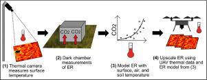
Field-based thermal infrared cameras provide surface temperature information at very high spatial and temporal resolution and could complement existing phenological camera and spectral sensor networks. Since temperature is one of the main drivers of ecosystem respiration (ER), field-based thermal cameras offer a new opportunity to model and upscale ER in unprecedented detail. We present such an approach based on manual chamber CO2 flux measurements and thermal imagery from a tower-based camera and from Unmanned Aerial Vehicle (UAV) flights. Data were collected over two growing seasons, including the hot drought of 2018, for the two main vegetation microforms (hummock and hollow) of a hemi-boreal peatland in Sweden. Thermal imagery proved suitable for modelling ER in this ecosystem: ER model accuracies were similar when air, soil or surface temperature measurements were used as input. Our findings allowed us to upscale ER using UAV-derived thermal images and we present maps of ER at sub-decimeter resolution (<7 cm). The significantly different ER measured for each microform highlighted the importance of modelling their ER separately. Not accounting for these differences and the microforms' spatial distribution across the peatland led to a bias in upscaled ER of up to 18%. As a result of the severity and timing of the hot drought in 2018, we observed reductions in the ER of both microforms, but more so for hummocks (-48%) than for hollows (-15%), and modelled ER leveled off at high temperatures. These findings indicate that peatland carbon loss during hot droughts may be lower than expected and strongly relates to vegetation composition. The presented upscaling approach offers a new method to analyse how ER varies across a peatland or within a flux-tower footprint, and to interpret biases that occur when using coarse resolution satellite data to upscale chamber or tower-based flux measurements.
中文翻译:
使用热像仪和无人机对生态系统呼吸进行建模和扩展:在干旱干旱期间和干旱之后应用于泥炭地
基于现场的红外热像仪可在非常高的空间和时间分辨率下提供表面温度信息,并且可以补充现有的物候热像仪和光谱传感器网络。由于温度是生态系统呼吸(ER)的主要驱动因素之一,因此基于现场的热像仪为以前所未有的细节建模和放大ER提供了新的机会。我们提出了一种基于手动室CO 2的方法塔式相机和无人机(UAV)飞行的光通量测量和热成像。收集了两个生长季节的数据,包括2018年的高温干旱,这是瑞典一个半北方泥炭地的两种主要植被微型形态(山岗和中空)。热成像证明适合在此生态系统中对ER进行建模:当使用空气,土壤或地表温度测量作为输入时,ER模型的准确性相似。我们的发现使我们能够使用源自无人机的热图像来放大ER,并以亚分米分辨率(<7 cm)呈现ER图。为每种微表格测量的显着不同的ER突显了分别建模其ER的重要性。不考虑这些差异和缩微胶片的 整个泥炭地的空间分布导致最高ER偏差高达18%。由于2018年炎热干旱的严重性和时机,我们观察到两种微缩模型的ER降低,但山雀(-48%)的降低幅度更大,而空心凹陷(-15%)的降低幅度更大,并且模型化ER稳定在高温。这些发现表明,干旱干旱期间泥炭地的碳损失可能低于预期,并且与植被组成密切相关。提出的升级方法提供了一种新方法,可以分析泥炭地或通量塔足迹内的ER的变化,并解释使用粗分辨率卫星数据进行基于腔室或塔基通量测量的误差。但对于山包(-48%)而言,比中空洞(-15%)更是如此,并且模型化的ER在高温下趋于平稳。这些发现表明,干旱干旱期间泥炭地的碳损失可能低于预期,并且与植被组成密切相关。提出的升级方法提供了一种新方法,可以分析泥炭地或通量塔足迹内的ER的变化,并解释使用粗分辨率卫星数据进行基于腔室或塔基通量测量的误差。但对于山包(-48%)而言,比中空洞(-15%)更是如此,并且模型化的ER在高温下趋于平稳。这些发现表明,干旱干旱期间泥炭地的碳损失可能低于预期,并且与植被组成密切相关。提出的升级方法提供了一种新方法,可以分析泥炭地或通量塔足迹内的ER的变化,并解释使用粗分辨率卫星数据进行基于腔室或塔基通量测量的误差。


 京公网安备 11010802027423号