当前位置:
X-MOL 学术
›
Int. J. Climatol.
›
论文详情
Our official English website, www.x-mol.net, welcomes your feedback! (Note: you will need to create a separate account there.)
Synoptic timescale linkage between midlatitude winter troughs Sahara temperature patterns and northern Congo rainfall: A building block of regional climate variability
International Journal of Climatology ( IF 3.9 ) Pub Date : 2021-01-14 , DOI: 10.1002/joc.7011 Neil Ward 1 , Andreas H. Fink 2 , Richard J. Keane 1, 3 , Françoise Guichard 4 , John H. Marsham 1, 5 , Douglas J. Parker 1 , Christopher M. Taylor 6, 7
International Journal of Climatology ( IF 3.9 ) Pub Date : 2021-01-14 , DOI: 10.1002/joc.7011 Neil Ward 1 , Andreas H. Fink 2 , Richard J. Keane 1, 3 , Françoise Guichard 4 , John H. Marsham 1, 5 , Douglas J. Parker 1 , Christopher M. Taylor 6, 7
Affiliation
|
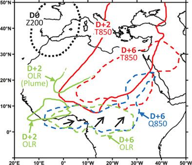
A coherent synoptic sequence, mostly over North Africa, is identified whereby an upper‐level midlatitude trough (in November–March) excites several days of quasi‐stationary near‐surface warming across the Sahara, leading to rainfall events over northern Congo (NC), and perturbed weather more widely. Ahead of NC rainfall events, composite sequences first identify troughs for several days near Iberia, followed by relatively quick transfer to the Central Mediterranean (CMed). Iberia and CMed daily trough‐strength indices reveal that both lead to warming and NC rainfall. Iberia trough linkages develop through West Africa and take longer to reach NC, while CMed linkages reach NC faster (2–3 days), with impact extent focused mostly south and east of CMed. Building up to the rainfall events, initial warming over the central Sahara migrates southeastward close to NC, ultimately with typical magnitude of about 1–2°C at 10–15°N. Such anomalies are statistically predictive for NC daily rainfall and associated nearby atmospheric features: anomalous low‐level southerly wind and increased moisture; anomalous low‐level westerly wind and vertical easterly shear to 600 hPa; increased mid‐level moisture (600 hPa), which along with low‐level moisture, connects northward into midlatitudes. A secondary route identified by which Iberia troughs can impact NC rainfall is through direct atmospheric teleconnection with precipitation to the west of NC, and subsequent migration of that convection eastward into NC. The eastern side of NC generally shows a small lag on western parts, and links more strongly to CMed troughs. Taken together, the lagged synoptic expression of Iberia and CMed troughs is widespread over several days, including much of North Africa (to equatorial latitudes), southwestern Asia, eastern Africa and the western Indian Ocean. Overall, these results can contribute to situational awareness for weather forecasters across the zones influenced by the troughs, while also providing a framework for climate timescale analyses.
中文翻译:

中纬度冬季低谷撒哈拉沙漠温度模式与刚果北部降水之间的天气时标联系:区域气候变化的基础
确定了一个连贯的天气序列,主要是在北非上空,从而使上中纬度低谷(11月至3月)激发了整个撒哈拉地区几天的准平稳近地表增温,导致了刚果北部(NC)的降雨事件,并且天气范围更广。在发生NC降雨事件之前,复合序列首先确定伊比利亚附近几天的低谷,然后相对较快地转移到地中海中部(CMed)。伊比利亚和CMed的日槽强度指数表明,这两者都会导致变暖和北卡罗来纳州降雨。伊比利亚波谷联系在整个西非发展,到达NC所需的时间更长,而CMed联系则更快(2-3天)到达NC,其影响程度主要集中在CMed的南部和东部。建立降雨事件,撒哈拉中部地区的初始变暖向东南方向靠近NC迁移,最终在10–15°N时的典型幅度约为1-2°C。这些异常在统计学上可预测北卡罗来纳州的每日降水量和附近的相关大气特征:异常低水平的南风和湿度增加;异常低空西风和垂直东风剪切至600 hPa; 中水平湿度(600 hPa)的增加,再加上低水平湿度,将北向连接到中纬度地区。伊比利亚波谷可以影响北卡罗来纳州降雨的第二条途径是通过直接大气遥传与北卡罗来纳州西部的降水,以及随后该对流向东迁移到北卡罗来纳州。北卡罗来纳州的东部通常在西部地区显示出较小的滞后,并且与CMed谷之间的联系更加紧密。在一起 伊比利亚和CMed低谷的滞后天气表达在几天之内很普遍,包括北非(至赤道纬度),西南亚,东非和西印度洋的大部分地区。总体而言,这些结果有助于提高受槽影响区域内天气预报员的态势感知,同时也为气候时间尺度分析提供框架。
更新日期:2021-01-14
中文翻译:
中纬度冬季低谷撒哈拉沙漠温度模式与刚果北部降水之间的天气时标联系:区域气候变化的基础
确定了一个连贯的天气序列,主要是在北非上空,从而使上中纬度低谷(11月至3月)激发了整个撒哈拉地区几天的准平稳近地表增温,导致了刚果北部(NC)的降雨事件,并且天气范围更广。在发生NC降雨事件之前,复合序列首先确定伊比利亚附近几天的低谷,然后相对较快地转移到地中海中部(CMed)。伊比利亚和CMed的日槽强度指数表明,这两者都会导致变暖和北卡罗来纳州降雨。伊比利亚波谷联系在整个西非发展,到达NC所需的时间更长,而CMed联系则更快(2-3天)到达NC,其影响程度主要集中在CMed的南部和东部。建立降雨事件,撒哈拉中部地区的初始变暖向东南方向靠近NC迁移,最终在10–15°N时的典型幅度约为1-2°C。这些异常在统计学上可预测北卡罗来纳州的每日降水量和附近的相关大气特征:异常低水平的南风和湿度增加;异常低空西风和垂直东风剪切至600 hPa; 中水平湿度(600 hPa)的增加,再加上低水平湿度,将北向连接到中纬度地区。伊比利亚波谷可以影响北卡罗来纳州降雨的第二条途径是通过直接大气遥传与北卡罗来纳州西部的降水,以及随后该对流向东迁移到北卡罗来纳州。北卡罗来纳州的东部通常在西部地区显示出较小的滞后,并且与CMed谷之间的联系更加紧密。在一起 伊比利亚和CMed低谷的滞后天气表达在几天之内很普遍,包括北非(至赤道纬度),西南亚,东非和西印度洋的大部分地区。总体而言,这些结果有助于提高受槽影响区域内天气预报员的态势感知,同时也为气候时间尺度分析提供框架。


 京公网安备 11010802027423号