Journal of South American Earth Sciences ( IF 1.8 ) Pub Date : 2021-01-12 , DOI: 10.1016/j.jsames.2020.103153 Maíra Martim de Moura , Samuel Beskow , Fabrício da Silva Terra , Carlos Rogério de Mello , Zandra Almeida da Cunha , Felício Cassalho
|
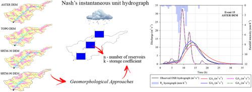
Methodologies for estimation of direct surface runoff (DSR) hydrographs have been proposed, especially for the Unit Hydrograph (UH) and Instantaneous Unit Hydrograph (IUH). The widely used IUH developed by Nash (NIUH) has two main parameters: number of reservoirs (n) and storage coefficient (k), which by definition are determined based on observed rainfall-runoff events. In order to overcome the need for hydrological data for application of NIUH, geomorphological approaches (GAs) have been developed to provide the aforementioned parameters for ungauged watersheds, thus allowing for the estimation of DSR hydrographs using only relief information. The aim of this study was to evaluate the performance of 4 GAs (GA1 - Nash, 1960; GA2 - Wu, 1963; GA3 - Rosso, 1984; GA4 - Bhaskar et al., 1997). Moreover, this study sought to investigate the influence of different digital elevation models (DEMs) (TOPO, ASTER, SRTM-30 and SRTM-90) on the determination of geomorphological attributes necessary for the application of the above-mentioned GAs. Twenty rainfall-runoff events observed in a small Brazilian watershed were used to evaluate the performance of NIUH combined with different GAs and DEMs for estimation of DSR hydrographs. In view of the results found in this study, the main conclusions are: i) the GAs exert more influence on the parameters n and k than the DEMs; ii) GA1 and GA2 outperformed GA3 and GA4; and iii) GA2 coupled with the ASTER DEM results in the best estimates of DSR hydrographs.
中文翻译:
结合Nash瞬时单位水位图的数字高程模型评估地貌方法
已经提出了估计直接地表径流(DSR)水位图的方法,尤其是对于单位水位图(UH)和瞬时单位水位图(IUH)。纳什(NIUH)开发的被广泛使用的IUH具有两个主要参数:水库数量(n)和储水系数(k),根据定义,这些参数是根据观测到的降雨径流事件确定的。为了克服对于应用NIUH的水文数据的需求,已经开发了地貌方法(GAs)为未加水的流域提供上述参数,从而允许仅使用地形信息来估算DSR水文图。这项研究的目的是评估4种GA的性能(GA 1 -Nash,1960年; GA 2 -Wu,1963年; GA 3-罗索(Rosso),1984年;GA 4 -Bhaskar等,1997)。此外,本研究试图调查不同数字高程模型(DEM)(TOPO,ASTER,SRTM-30和SRTM-90)对确定应用上述GA所需的地貌属性的影响。在巴西一个小流域观察到的20个降雨径流事件被用于评估NIUH结合不同的GA和DEM来评估DSR水文图的性能。根据本研究的结果,主要结论是:i)GA对参数n和k的影响大于DEM。ii)GA 1和GA 2优于GA 3和GA 4;和iii)GA 2 结合ASTER DEM可以对DSR水文图进行最佳估计。


 京公网安备 11010802027423号