当前位置:
X-MOL 学术
›
Basin Res.
›
论文详情
Our official English website, www.x-mol.net, welcomes your feedback! (Note: you will need to create a separate account there.)
Syn-rift sediment gravity flow deposition on a Late Jurassic fault-terraced slope, northern North Sea
Basin Research ( IF 3.2 ) Pub Date : 2021-01-08 , DOI: 10.1111/bre.12538 Fabian Tillmans 1 , Robert L. Gawthorpe 1 , Christopher A‐L. Jackson 2 , Atle Rotevatn 1
Basin Research ( IF 3.2 ) Pub Date : 2021-01-08 , DOI: 10.1111/bre.12538 Fabian Tillmans 1 , Robert L. Gawthorpe 1 , Christopher A‐L. Jackson 2 , Atle Rotevatn 1
Affiliation
|
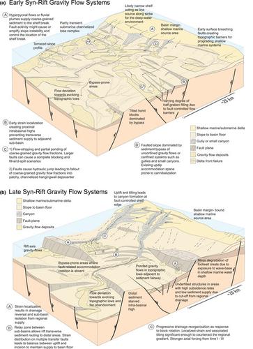
Structurally controlled bathymetry in rifts has a significant influence on sediment routing pathways and depositional architecture of sediment gravity flow deposits. In contrast to rift segments characterized by crustal-scale half-grabens, the tectono-stratigraphic evolution of deep-water rift domains characterised by distributed faulting on narrow fault terraces has received little attention. We use 3D broadband seismic data, calibrated by boreholes, from the Lomre and Uer terraces in the northern North Sea rift to investigate Late Jurassic syn-rift sediment gravity flow systems on fault-terraced slopes. The sediment gravity flow fairways were sourced from hinterland drainages via basin margin deltaic systems on the Horda Platform to the southeast. The deep-water sedimentary systems evolve from initial, widespread submarine channelized lobe complexes, through submarine channels, to incised submarine canyons. This progressive confinement of the sediment gravity flow system was concomitant with progressive localization of strain onto the main terrace-bounding faults. Although the normal fault network on the terraces has local impact on deep-water sediment transport and the architecture of gravity flow deposits, it is the regional basin margin to rift axis gradient that dominantly controls deep-water sediment routing. Furthermore, the gravity flow deposits on the Lomre and Uer terraces were predominantly sourced by rift margin deltaic systems, not from erosion of local uplifted footwall crests, emphasising the significance of hinterland catchments in the development of volumetrically significant deep-water syn-rift depositional systems.
中文翻译:

北海北部晚侏罗世断层斜坡上的速裂泥沙重力流沉积
裂谷中的结构控制测深法对沉积物的路径和沉积物重力流沉积物的沉积结构具有重大影响。与以地壳尺度的半岩为特征的裂谷段相比,以狭窄的断层阶地上的分布断层为特征的深水裂谷域的构造-地层演化很少受到关注。我们使用北海裂谷的Lomre和Uer阶地的3D宽带地震数据(经钻孔校准)来研究断层斜坡上的晚侏罗世同裂谷沉积物重力流系统。沉积物重力流航道来自腹地排水,通过霍达平台东南部的盆地边缘三角洲系统。深水沉积系统是从最初的 广泛的海底通道化的波状波群通过海底通道到达切入的海底峡谷。沉积物重力流系统的这种渐进的限制伴随着应变在主要阶地边界断层上的渐进定位。尽管阶地上的正常断层网络对深水沉积物的输送和重力流沉积的结构有局部影响,但裂谷轴梯度的区域盆地边缘是控制深水沉积物路线的主要因素。此外,Lomre和Uer阶地上的重力流沉积物主要来自裂谷缘三角洲系统,而不是局部隆起的底盘波峰的侵蚀,强调了腹地集水区在体积显着的深水同分立沉积系统发展中的重要性。 。通过海底通道,切入海底峡谷。沉积物重力流系统的这种渐进的限制伴随着应变在主要阶地边界断层上的渐进定位。尽管阶地上的正常断层网络对深水沉积物的输送和重力流沉积的结构有局部影响,但裂谷轴梯度的区域盆地边缘是控制深水沉积物路线的主要因素。此外,Lomre和Uer阶地上的重力流沉积物主要来自裂谷缘三角洲系统,而不是局部隆起的底盘波峰的侵蚀,强调了腹地集水区在体积显着的深水同分立沉积系统发展中的重要性。 。通过海底通道,切入海底峡谷。沉积物重力流系统的这种渐进的限制伴随着应变在主要阶地边界断层上的渐进定位。尽管阶地上的正常断层网络对深水沉积物的输送和重力流沉积的结构有局部影响,但裂谷轴梯度的区域盆地边缘是控制深水沉积物路线的主要因素。此外,Lomre和Uer阶地上的重力流沉积物主要来自裂谷缘三角洲系统,而不是局部隆起的底盘波峰的侵蚀,强调了腹地集水区在体积显着的深水同分立沉积系统发展中的重要性。 。沉积物重力流系统的这种渐进的限制伴随着应变在主要阶地边界断层上的渐进定位。尽管阶地上的正常断层网络对深水沉积物的输送和重力流沉积的结构有局部影响,但裂谷轴梯度的区域盆地边缘是控制深水沉积物路线的主要因素。此外,Lomre和Uer阶地上的重力流沉积物主要来自裂谷缘三角洲系统,而不是局部隆起的底盘波峰的侵蚀,强调了腹地集水区在体积显着的深水同分立沉积系统发展中的重要性。 。沉积物重力流系统的这种渐进的限制伴随着应变在主要阶地边界断层上的渐进定位。尽管阶地上的正常断层网络对深水沉积物的输送和重力流沉积的结构有局部影响,但裂谷轴梯度的区域盆地边缘是控制深水沉积物路线的主要因素。此外,Lomre和Uer阶地上的重力流沉积物主要来自裂谷缘三角洲系统,而不是局部隆起的底盘波峰的侵蚀,强调了腹地集水区在体积显着的深水同分立沉积系统发展中的重要性。 。
更新日期:2021-01-08
中文翻译:
北海北部晚侏罗世断层斜坡上的速裂泥沙重力流沉积
裂谷中的结构控制测深法对沉积物的路径和沉积物重力流沉积物的沉积结构具有重大影响。与以地壳尺度的半岩为特征的裂谷段相比,以狭窄的断层阶地上的分布断层为特征的深水裂谷域的构造-地层演化很少受到关注。我们使用北海裂谷的Lomre和Uer阶地的3D宽带地震数据(经钻孔校准)来研究断层斜坡上的晚侏罗世同裂谷沉积物重力流系统。沉积物重力流航道来自腹地排水,通过霍达平台东南部的盆地边缘三角洲系统。深水沉积系统是从最初的 广泛的海底通道化的波状波群通过海底通道到达切入的海底峡谷。沉积物重力流系统的这种渐进的限制伴随着应变在主要阶地边界断层上的渐进定位。尽管阶地上的正常断层网络对深水沉积物的输送和重力流沉积的结构有局部影响,但裂谷轴梯度的区域盆地边缘是控制深水沉积物路线的主要因素。此外,Lomre和Uer阶地上的重力流沉积物主要来自裂谷缘三角洲系统,而不是局部隆起的底盘波峰的侵蚀,强调了腹地集水区在体积显着的深水同分立沉积系统发展中的重要性。 。通过海底通道,切入海底峡谷。沉积物重力流系统的这种渐进的限制伴随着应变在主要阶地边界断层上的渐进定位。尽管阶地上的正常断层网络对深水沉积物的输送和重力流沉积的结构有局部影响,但裂谷轴梯度的区域盆地边缘是控制深水沉积物路线的主要因素。此外,Lomre和Uer阶地上的重力流沉积物主要来自裂谷缘三角洲系统,而不是局部隆起的底盘波峰的侵蚀,强调了腹地集水区在体积显着的深水同分立沉积系统发展中的重要性。 。通过海底通道,切入海底峡谷。沉积物重力流系统的这种渐进的限制伴随着应变在主要阶地边界断层上的渐进定位。尽管阶地上的正常断层网络对深水沉积物的输送和重力流沉积的结构有局部影响,但裂谷轴梯度的区域盆地边缘是控制深水沉积物路线的主要因素。此外,Lomre和Uer阶地上的重力流沉积物主要来自裂谷缘三角洲系统,而不是局部隆起的底盘波峰的侵蚀,强调了腹地集水区在体积显着的深水同分立沉积系统发展中的重要性。 。沉积物重力流系统的这种渐进的限制伴随着应变在主要阶地边界断层上的渐进定位。尽管阶地上的正常断层网络对深水沉积物的输送和重力流沉积的结构有局部影响,但裂谷轴梯度的区域盆地边缘是控制深水沉积物路线的主要因素。此外,Lomre和Uer阶地上的重力流沉积物主要来自裂谷缘三角洲系统,而不是局部隆起的底盘波峰的侵蚀,强调了腹地集水区在体积显着的深水同分立沉积系统发展中的重要性。 。沉积物重力流系统的这种渐进的限制伴随着应变在主要阶地边界断层上的渐进定位。尽管阶地上的正常断层网络对深水沉积物的输送和重力流沉积的结构有局部影响,但裂谷轴梯度的区域盆地边缘是控制深水沉积物路线的主要因素。此外,Lomre和Uer阶地上的重力流沉积物主要来自裂谷缘三角洲系统,而不是局部隆起的底盘波峰的侵蚀,强调了腹地集水区在体积显着的深水同分立沉积系统发展中的重要性。 。


 京公网安备 11010802027423号