Gondwana Research ( IF 6.1 ) Pub Date : 2021-01-05 , DOI: 10.1016/j.gr.2020.11.016 Alexandra Guy , K. Schulmann , I. Soejono , N. Holzrichter , O. Lexa , M. Munschy

|
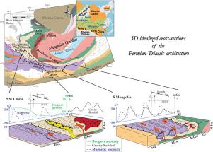
A multidisciplinary approach integrating potential field analysis with geological and geochemical data provides new insights into the understanding of the crustal structure and evolution of the Mongolian collage. Magnetic and gravity data demonstrate the inconsistency between the geologically defined terranes and the geophysical domains in the southwestern part of the Mongolian collage. The combination of potential field analysis and modelling with whole rock geochemistry and isotopic mapping of Carboniferous–Permian granitoids indicates the presence of a homogeneous lower crust composed of a felsic to intermediate juvenile material beneath geophysically heterogeneous upper crust. This feature is interpreted as a result of a trench-directed lower crustal emplacement of an arc type crust underplating deformed Paleozoic oceanic crust. The potential field data also confirmed the occurrence of two orthogonal late Devonian and Permian–Triassic deformation upper crustal fabrics at the scale of the southwestern Mongolian collage. The prominent magnetic highs correspond to the tectono-metamorphic domains and magmatic provinces. The gravity anomalies highlight a periodicity of the signal correlating with alternating Permian–Triassic high and low strain zones, forming a zone of major deformation wrapping around the hinge of Mongolian orocline. The geometry and kinematics of dextral and sinistral transpressive faults are explained to result from the reactivation of Permian–Triassic deformation zones in the Cenozoic stress field.
中文翻译:

受势场分析约束的中亚造山带蒙古道的结构和地球动力学
将学科领域分析与地质和地球化学数据结合起来的多学科方法为了解蒙古拼贴的地壳结构和演化提供了新的见识。磁和重力数据表明,地质定界的地貌与蒙古拼贴西南部的地球物理域之间不一致。势场分析和建模与全岩石地球化学和石炭纪-二叠纪花岗岩的同位素制图相结合,表明存在一个均匀的下地壳,该地壳由地球物理上不均匀的上地壳下的长英质到中等的幼年组成。解释此特征的原因是,弧形地壳的沟槽定向下地壳就位,该地壳底部镀覆了变形的古生代大洋地壳。潜在的田野数据还证实了在蒙古西南拼贴范围内发生了两种正交的晚泥盆世和二叠纪-三叠纪形变上部地壳构造。突出的磁高对应于构造变质域和岩浆区。重力异常突出了信号的周期性,该信号与二叠系-三叠纪的高应变区和低应变区相关,形成了围绕蒙古Orocline铰链包裹的主要变形区。右旋和左旋超压断层的几何学和运动学被解释为新生代应力场中二叠系-三叠纪变形带的重新激活所致。


 京公网安备 11010802027423号