Geomorphology ( IF 3.9 ) Pub Date : 2021-01-05 , DOI: 10.1016/j.geomorph.2020.107591 Anita Bernatek-Jakiel , Michał Jakiel
|
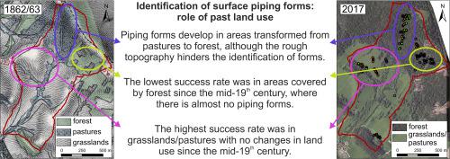
The detection of soil piping features is still a challenging issue that requires further studies, especially at larger scale. It seems that field mapping as a time-consuming method can be supported by the new technologies. This study has exploited the freely available airborne LiDAR (Light Detection and Ranging) digital elevation model (DEM) to explore piping-related depressions. The aim was to test the possibility of digital detection of piping forms using sink-fill method and different derivatives of airborne LiDAR DEM (slope, Topographic Position Index, Topographic Ruggedness Index, Positive and Negative Openness Index) in order of its utility in regional scale studies. As geological structure, soils and climate are similar in the whole study area, the analysis was extended to include the changes in land use/land cover (LULC) in the last two centuries (1862–2017). The results were verified by the detailed geomorphological mapping in the field. The study was conducted in a small catchment in the Bieszczady Mts. (SE Poland) covered by forests and grasslands/pastures, where in the past transition from pastures to forests was observed. The findings have revealed the great impact of LULC changes on soil piping, thus also on the possibility of digital mapping which is often based only on topographic information. The success rate in recognition was satisfactory on grasslands/pastures (76% for individual forms and 80% for piping systems). Areas covered by forests since the mid-19th century are unlikely places to develop piping forms (just 2 forms found) in the study area, whereas places where transition from pastures to forest has been observed may be prone to soil piping. However, the digital identification of piping forms in areas with rough topography is difficult (a success rate of 45% for individual forms and 50% for piping systems). The digital mapping of piping forms cannot rely only on the topographic information but should be always accompanied by an analysis of factors controlling piping erosion.
中文翻译:
使用机载LiDAR DEM识别与土壤管道相关的洼地:土地用途变化的作用
土壤管道特征的检测仍然是一个具有挑战性的问题,需要进一步研究,尤其是在更大范围内。新技术似乎可以支持将字段映射作为一种耗时的方法。这项研究利用了免费提供的机载LiDAR(光检测和测距)数字高程模型(DEM)来探索与管道相关的凹陷。目的是测试使用水槽填充法和机载LiDAR DEM的不同导数(坡度,地形位置指数,地形坚固性指数,正负开放度指数)进行数字检测管道形式的可能性,以便按其在区域范围内的使用顺序进行排序学习。由于整个研究区域的地质结构,土壤和气候相似,该分析扩展到包括过去两个世纪(1862-2017年)的土地利用/土地覆盖率(LULC)的变化。通过现场详细的地貌图验证了结果。该研究是在比斯卡扎迪山的一个小流域进行的。(波兰东南部)被森林和草原/草场覆盖,过去曾观察到从牧场到森林的过渡。研究结果揭示了LULC变化对土壤管道的巨大影响,因此也揭示了通常仅基于地形信息的数字制图的可能性。草地/草场的认可成功率令人满意(个人形式为76%,管道系统为80%)。自19世纪中叶以来,森林覆盖的区域不太可能在研究区域内开发出管道形式(仅发现了2种形式),而观察到从牧场到森林过渡的地方可能容易出现土壤管道。但是,很难对具有粗糙地形的区域中的管道形式进行数字识别(单个形式的成功率为45%,管道系统的成功率为50%)。管道形式的数字绘图不能仅依赖于地形信息,而应始终伴随着控制管道侵蚀的因素分析。


 京公网安备 11010802027423号