当前位置:
X-MOL 学术
›
Q. J. R. Meteorol. Soc.
›
论文详情
Our official English website, www.x-mol.net, welcomes your feedback! (Note: you will need to create a separate account there.)
Central Arctic weather forecasting: Confronting the ECMWF IFS with observations from the Arctic Ocean 2018 expedition
Quarterly Journal of the Royal Meteorological Society ( IF 8.9 ) Pub Date : 2020-12-27 , DOI: 10.1002/qj.3971 Michael Tjernström 1 , Gunilla Svensson 1 , Linus Magnusson 2 , Ian M. Brooks 3 , John Prytherch 1 , Jutta Vüllers 3 , Gillian Young 3
Quarterly Journal of the Royal Meteorological Society ( IF 8.9 ) Pub Date : 2020-12-27 , DOI: 10.1002/qj.3971 Michael Tjernström 1 , Gunilla Svensson 1 , Linus Magnusson 2 , Ian M. Brooks 3 , John Prytherch 1 , Jutta Vüllers 3 , Gillian Young 3
Affiliation
|
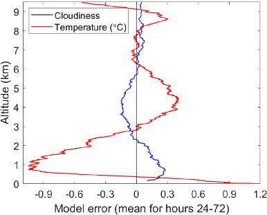
Forecasts with the European Centre for Medium‐Range Weather Forecasts' numerical weather prediction model are evaluated using an extensive set of observations from the Arctic Ocean 2018 expedition on the Swedish icebreaker Oden. The atmospheric model (Cy45r1) is similar to that used for the ERA5 reanalysis (Cy41r2). The evaluation covers 1 month, with the icebreaker moored to drifting sea ice near the North Pole; a total of 125 forecasts issued four times per day were used. Standard surface observations and 6‐hourly soundings were assimilated to ensure that the initial model error is small. Model errors can be divided into two groups. First, variables related to dynamics feature errors that grow with forecast length; error spread also grows with time. Initial errors are small, facilitating a robust evaluation of the second group; thermodynamic variables. These feature fast error growth for 6–12 hr, after which errors saturates; error spread is roughly constant. Both surface and near‐surface air temperatures are too warm in the model. During the summer both are typically above zero in spite of the ongoing melt; however, the warm bias increases as the surface freezes. The warm bias is due to a too warm atmosphere; errors in surface sensible heat flux transfer additional heat from the atmosphere to the surface. The lower troposphere temperature error has a distinct vertical structure: a substantial warm bias in the lowest few 100 m and a large cold bias around 1 km; this structure features a significant diurnal cycle and is tightly coupled to errors in the modelled clouds. Clouds appear too often and in a too deep layer of the lower atmosphere; the lowest clouds essentially never break up. The largest error in cloud presence is aligned with the largest cold bias at around 1 km.
中文翻译:

北极中部天气预报:将ECMWF IFS与2018年北冰洋远征的观测结果相面对
欧洲中距离天气预报中心的数值天气预报模型是根据2018年北冰洋探险队对瑞典破冰船Oden进行的一系列观测评估而得出的。大气模型(Cy45r1)与用于ERA5重新分析(Cy41r2)的模型相似。评估历时1个月,破冰船停泊在北极附近的漂流海冰上;总共使用了每天四次发布的125个预测。将标准的地面观测资料和6小时的测深值同化,以确保初始模型误差较小。模型错误可分为两组。首先,与动力学相关的变量具有随预测长度而增长的误差。错误传播也随着时间而增长。初始误差很小,有助于对第二组进行可靠的评估;热力学变量。这些功能可在6到12个小时内快速增加错误,此后错误会饱和。误差分布大致是恒定的。在模型中,地表和近地表的空气温度都太高。在夏季,尽管融化不断,两者通常都高于零。然而,随着表面结冰,热偏压会增加。偏热是由于气氛太热所致。表面显热通量的误差将额外的热量从大气传递到表面。对流层较低的温度误差具有明显的垂直结构:最低的100 m处有明显的暖偏,约1 km处有较大的冷偏;这种结构具有明显的昼夜周期,并且与建模云中的误差紧密相关。云层太频繁地出现在较低的大气层中。最低的云基本上不会破裂。云中存在的最大误差与大约1 km处的最大冷偏差一致。偏热是由于气氛太热所致。表面显热通量的误差将额外的热量从大气传递到表面。对流层较低的温度误差具有明显的垂直结构:最低的100 m处有明显的暖偏,约1 km处有较大的冷偏;这种结构具有明显的昼夜周期,并且与建模云中的误差紧密相关。云层太频繁地出现在较低的大气层中。最低的云基本上不会破裂。云中存在的最大误差与大约1 km处的最大冷偏差一致。偏热是由于气氛太热所致。表面显热通量的误差将额外的热量从大气传递到表面。对流层较低的温度误差具有明显的垂直结构:最低的100 m处有明显的暖偏,约1 km处有较大的冷偏;这种结构具有明显的昼夜周期,并且与建模云中的误差紧密相关。云层太频繁地出现在较低的大气层中。最低的云基本上不会破裂。云中存在的最大误差与大约1 km处的最大冷偏差一致。在最低的100 m处有很大的暖偏,在1 km左右有很大的冷偏;这种结构具有明显的昼夜周期,并且与建模云中的误差紧密相关。云层太频繁地出现在较低的大气层中。最低的云基本上不会破裂。云中存在的最大误差与大约1 km处的最大冷偏差一致。在最低的100 m处有很大的暖偏,在1 km左右有很大的冷偏;这种结构具有明显的昼夜周期,并且与建模云中的误差紧密相关。云层太频繁地出现在较低的大气层中。最低的云基本上不会破裂。云中存在的最大误差与大约1 km处的最大冷偏差一致。
更新日期:2021-03-07
中文翻译:
北极中部天气预报:将ECMWF IFS与2018年北冰洋远征的观测结果相面对
欧洲中距离天气预报中心的数值天气预报模型是根据2018年北冰洋探险队对瑞典破冰船Oden进行的一系列观测评估而得出的。大气模型(Cy45r1)与用于ERA5重新分析(Cy41r2)的模型相似。评估历时1个月,破冰船停泊在北极附近的漂流海冰上;总共使用了每天四次发布的125个预测。将标准的地面观测资料和6小时的测深值同化,以确保初始模型误差较小。模型错误可分为两组。首先,与动力学相关的变量具有随预测长度而增长的误差。错误传播也随着时间而增长。初始误差很小,有助于对第二组进行可靠的评估;热力学变量。这些功能可在6到12个小时内快速增加错误,此后错误会饱和。误差分布大致是恒定的。在模型中,地表和近地表的空气温度都太高。在夏季,尽管融化不断,两者通常都高于零。然而,随着表面结冰,热偏压会增加。偏热是由于气氛太热所致。表面显热通量的误差将额外的热量从大气传递到表面。对流层较低的温度误差具有明显的垂直结构:最低的100 m处有明显的暖偏,约1 km处有较大的冷偏;这种结构具有明显的昼夜周期,并且与建模云中的误差紧密相关。云层太频繁地出现在较低的大气层中。最低的云基本上不会破裂。云中存在的最大误差与大约1 km处的最大冷偏差一致。偏热是由于气氛太热所致。表面显热通量的误差将额外的热量从大气传递到表面。对流层较低的温度误差具有明显的垂直结构:最低的100 m处有明显的暖偏,约1 km处有较大的冷偏;这种结构具有明显的昼夜周期,并且与建模云中的误差紧密相关。云层太频繁地出现在较低的大气层中。最低的云基本上不会破裂。云中存在的最大误差与大约1 km处的最大冷偏差一致。偏热是由于气氛太热所致。表面显热通量的误差将额外的热量从大气传递到表面。对流层较低的温度误差具有明显的垂直结构:最低的100 m处有明显的暖偏,约1 km处有较大的冷偏;这种结构具有明显的昼夜周期,并且与建模云中的误差紧密相关。云层太频繁地出现在较低的大气层中。最低的云基本上不会破裂。云中存在的最大误差与大约1 km处的最大冷偏差一致。在最低的100 m处有很大的暖偏,在1 km左右有很大的冷偏;这种结构具有明显的昼夜周期,并且与建模云中的误差紧密相关。云层太频繁地出现在较低的大气层中。最低的云基本上不会破裂。云中存在的最大误差与大约1 km处的最大冷偏差一致。在最低的100 m处有很大的暖偏,在1 km左右有很大的冷偏;这种结构具有明显的昼夜周期,并且与建模云中的误差紧密相关。云层太频繁地出现在较低的大气层中。最低的云基本上不会破裂。云中存在的最大误差与大约1 km处的最大冷偏差一致。


 京公网安备 11010802027423号