当前位置:
X-MOL 学术
›
Earth Surf.Process. Land.
›
论文详情
Our official English website, www.x-mol.net, welcomes your feedback! (Note: you will need to create a separate account there.)
A morphological investigation of marine transgression in estuaries
Earth Surface Processes and Landforms ( IF 3.3 ) Pub Date : 2020-12-25 , DOI: 10.1002/esp.5050 Ian Townend 1, 2 , Zeng Zhou 1 , Leicheng Guo 3 , Giovanni Coco 4
Earth Surface Processes and Landforms ( IF 3.3 ) Pub Date : 2020-12-25 , DOI: 10.1002/esp.5050 Ian Townend 1, 2 , Zeng Zhou 1 , Leicheng Guo 3 , Giovanni Coco 4
Affiliation
|
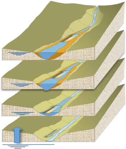
The landscape setting of estuaries varies widely and is an important aspect of determining how they evolve. This paper focusses on alluvial estuaries in river valleys and how they respond to sea level rise. We examine the implications of marine transgression, as a response to sea level rise, where the estuary moves upwards and landwards to maintain its position in the tidal frame (so‐called stratigraphic rollover). Here we encapsulate such kinematic movement of the estuary morphology using a ‘morphokinematic’ model, to assess the potential response to sea level rise and sediment supply. The model of the estuary form includes a single convergent channel, intertidal and surrounding floodplains (the valley) and allows the relative importance of the space available for deposition of sediments, the accommodation space, to be investigated as a function of rates of sea level rise and sediment supply. The transgression of the system is determined using a sediment mass balance, taking account of any supply from the river and marine environment. Model results confirm that the transgression distance, measured as the distance the entity moves landward, varies in proportion to the change in accommodation space, which mainly depends on the floodplain area. As the size of the floodplain reduces, the transgression distance is less and the system becomes much more sensitive to changes in the rate of sea level rise or changes in sediment supply. The greater demand for sediment when a floodplain is present results in greater cannibalization of the estuary form (i.e. greater landward movement) to meet the sediment demand. When the floodplain is disconnected from the estuary, the synergistic relationship is lost and the accommodation space increases. The capacity for restoration will depend on the availability of sediment and the prevailing rate of sea level rise.
中文翻译:

河口海侵的形态学研究
河口的地貌环境差异很大,是确定河口如何演变的重要方面。本文重点研究河谷的冲积河口及其对海平面上升的响应。我们研究了海侵作为对海平面上升的响应的含义,海平面上升并向海底移动,以保持其在潮汐架中的位置(所谓的地层翻转)。在这里,我们使用“形态动力学”模型封装了河口形态的这种运动学,以评估对海平面上升和沉积物供应的潜在响应。河口形式的模型包括单个汇流通道,潮间带和周围的洪泛区(山谷),并允许相对较大的可用于沉积物沉积的空间,容纳空间,将根据海平面上升速率和沉积物供应量进行调查。考虑到河流和海洋环境的任何供应,使用沉积物质量平衡来确定系统的违规行为。模型结果证实,越过距离,是随着实体向地面移动的距离而度量的,其随容纳空间的变化成比例地变化,而容纳空间的变化主要取决于洪泛区。随着洪泛区面积的减小,越过海峡的距离越短,并且该系统对海平面上升速度的变化或沉积物供应的变化变得更加敏感。当存在洪泛区时,对沉积物的更大需求导致河口形态的更大食人化(即更大的向内运动)来满足沉积物需求。当洪泛区与河口断开连接时,失去了协同关系,容纳空间增加了。恢复能力将取决于沉积物的可利用性和当前海平面上升的速度。
更新日期:2020-12-25
中文翻译:
河口海侵的形态学研究
河口的地貌环境差异很大,是确定河口如何演变的重要方面。本文重点研究河谷的冲积河口及其对海平面上升的响应。我们研究了海侵作为对海平面上升的响应的含义,海平面上升并向海底移动,以保持其在潮汐架中的位置(所谓的地层翻转)。在这里,我们使用“形态动力学”模型封装了河口形态的这种运动学,以评估对海平面上升和沉积物供应的潜在响应。河口形式的模型包括单个汇流通道,潮间带和周围的洪泛区(山谷),并允许相对较大的可用于沉积物沉积的空间,容纳空间,将根据海平面上升速率和沉积物供应量进行调查。考虑到河流和海洋环境的任何供应,使用沉积物质量平衡来确定系统的违规行为。模型结果证实,越过距离,是随着实体向地面移动的距离而度量的,其随容纳空间的变化成比例地变化,而容纳空间的变化主要取决于洪泛区。随着洪泛区面积的减小,越过海峡的距离越短,并且该系统对海平面上升速度的变化或沉积物供应的变化变得更加敏感。当存在洪泛区时,对沉积物的更大需求导致河口形态的更大食人化(即更大的向内运动)来满足沉积物需求。当洪泛区与河口断开连接时,失去了协同关系,容纳空间增加了。恢复能力将取决于沉积物的可利用性和当前海平面上升的速度。


 京公网安备 11010802027423号