当前位置:
X-MOL 学术
›
Remote Sens. Ecol. Conserv.
›
论文详情
Our official English website, www.x-mol.net, welcomes your feedback! (Note: you will need to create a separate account there.)
Using very-high-resolution satellite imagery and deep learning to detect and count African elephants in heterogeneous landscapes
Remote Sensing in Ecology and Conservation ( IF 5.5 ) Pub Date : 2020-12-23 , DOI: 10.1002/rse2.195 Isla Duporge 1 , Olga Isupova 2 , Steven Reece 3 , David W. Macdonald 1 , Tiejun Wang 4
Remote Sensing in Ecology and Conservation ( IF 5.5 ) Pub Date : 2020-12-23 , DOI: 10.1002/rse2.195 Isla Duporge 1 , Olga Isupova 2 , Steven Reece 3 , David W. Macdonald 1 , Tiejun Wang 4
Affiliation
|
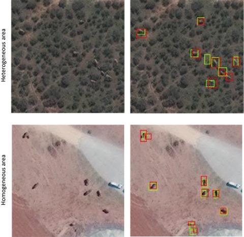
Satellites allow large-scale surveys to be conducted in short time periods with repeat surveys possible at intervals of <24 h. Very-high-resolution satellite imagery has been successfully used to detect and count a number of wildlife species in open, homogeneous landscapes and seascapes where target animals have a strong contrast with their environment. However, no research to date has detected animals in complex heterogeneous environments or detected elephants from space using very-high-resolution satellite imagery and deep learning. In this study, we apply a Convolution Neural Network (CNN) model to automatically detect and count African elephants in a woodland savanna ecosystem in South Africa. We use WorldView-3 and 4 satellite data –the highest resolution satellite imagery commercially available. We train and test the model on 11 images from 2014 to 2019. We compare the performance accuracy of the CNN against human accuracy. Additionally, we apply the model on a coarser resolution satellite image (GeoEye-1) captured in Kenya, without any additional training data, to test if the algorithm can generalize to an elephant population outside of the training area. Our results show that the CNN performs with high accuracy, comparable to human detection capabilities. The detection accuracy (i.e., F2 score) of the CNN models was 0.78 in heterogeneous areas and 0.73 in homogenous areas. This compares with the detection accuracy of the human labels with an averaged F2 score 0.77 in heterogeneous areas and 0.80 in homogenous areas. The CNN model can generalize to detect elephants in a different geographical location and from a lower resolution satellite. Our study demonstrates the feasibility of applying state-of-the-art satellite remote sensing and deep learning technologies for detecting and counting African elephants in heterogeneous landscapes. The study showcases the feasibility of using high resolution satellite imagery as a promising new wildlife surveying technique. Through creation of a customized training dataset and application of a Convolutional Neural Network, we have automated the detection of elephants in satellite imagery with accuracy as high as human detection capabilities. The success of the model to detect elephants outside of the training data site demonstrates the generalizability of the technique.
中文翻译:

使用超高分辨率卫星图像和深度学习来检测和计算异质景观中的非洲大象
卫星允许在短时间内进行大规模调查,并且可以以 <24 小时的间隔进行重复调查。超高分辨率卫星图像已成功用于在开放、均质的景观和海景中检测和计数许多野生动物物种,其中目标动物与环境形成强烈对比。然而,迄今为止,还没有研究在复杂的异质环境中检测到动物,也没有使用超高分辨率卫星图像和深度学习从太空中检测到大象。在这项研究中,我们应用卷积神经网络 (CNN) 模型来自动检测和计数南非林地稀树草原生态系统中的非洲大象。我们使用 WorldView-3 和 4 卫星数据——商业上可获得的最高分辨率卫星图像。我们在 2014 年至 2019 年的 11 张图像上训练和测试模型。我们将 CNN 的性能准确性与人类准确性进行比较。此外,我们在没有任何额外训练数据的情况下,将模型应用于在肯尼亚捕获的较粗分辨率的卫星图像 (GeoEye-1),以测试该算法是否可以推广到训练区域外的大象种群。我们的结果表明,CNN 具有高精度,可与人类检测能力相媲美。CNN 模型的检测精度(即 F2 分数)在异质区域为 0.78,在同质区域为 0.73。相比之下,人类标签的检测准确度在异质区域的平均 F2 得分为 0.77,在同质区域为 0.80。CNN 模型可以泛化以检测来自不同地理位置和较低分辨率卫星的大象。我们的研究证明了应用最先进的卫星遥感和深度学习技术在异质景观中检测和计数非洲大象的可行性。该研究展示了使用高分辨率卫星图像作为一种有前途的新野生动物调查技术的可行性。通过创建定制的训练数据集和应用卷积神经网络,我们在卫星图像中自动检测大象,其精度与人类检测能力一样高。该模型在训练数据站点之外检测大象的成功证明了该技术的普遍性。我们的研究证明了应用最先进的卫星遥感和深度学习技术在异质景观中检测和计数非洲大象的可行性。该研究展示了使用高分辨率卫星图像作为一种有前途的新野生动物调查技术的可行性。通过创建定制的训练数据集和应用卷积神经网络,我们在卫星图像中自动检测大象,其精度与人类检测能力一样高。该模型在训练数据站点之外检测大象的成功证明了该技术的普遍性。我们的研究证明了应用最先进的卫星遥感和深度学习技术在异质景观中检测和计数非洲大象的可行性。该研究展示了使用高分辨率卫星图像作为一种有前途的新野生动物调查技术的可行性。通过创建定制的训练数据集和应用卷积神经网络,我们在卫星图像中自动检测大象,其精度与人类检测能力一样高。该模型在训练数据站点之外检测大象的成功证明了该技术的普遍性。该研究展示了使用高分辨率卫星图像作为一种有前途的新野生动物调查技术的可行性。通过创建定制的训练数据集和应用卷积神经网络,我们在卫星图像中自动检测大象,其精度与人类检测能力一样高。该模型在训练数据站点之外检测大象的成功证明了该技术的普遍性。该研究展示了使用高分辨率卫星图像作为一种有前途的新野生动物调查技术的可行性。通过创建定制的训练数据集和应用卷积神经网络,我们在卫星图像中自动检测大象,其精度与人类检测能力一样高。该模型在训练数据站点之外检测大象的成功证明了该技术的普遍性。
更新日期:2020-12-23
中文翻译:
使用超高分辨率卫星图像和深度学习来检测和计算异质景观中的非洲大象
卫星允许在短时间内进行大规模调查,并且可以以 <24 小时的间隔进行重复调查。超高分辨率卫星图像已成功用于在开放、均质的景观和海景中检测和计数许多野生动物物种,其中目标动物与环境形成强烈对比。然而,迄今为止,还没有研究在复杂的异质环境中检测到动物,也没有使用超高分辨率卫星图像和深度学习从太空中检测到大象。在这项研究中,我们应用卷积神经网络 (CNN) 模型来自动检测和计数南非林地稀树草原生态系统中的非洲大象。我们使用 WorldView-3 和 4 卫星数据——商业上可获得的最高分辨率卫星图像。我们在 2014 年至 2019 年的 11 张图像上训练和测试模型。我们将 CNN 的性能准确性与人类准确性进行比较。此外,我们在没有任何额外训练数据的情况下,将模型应用于在肯尼亚捕获的较粗分辨率的卫星图像 (GeoEye-1),以测试该算法是否可以推广到训练区域外的大象种群。我们的结果表明,CNN 具有高精度,可与人类检测能力相媲美。CNN 模型的检测精度(即 F2 分数)在异质区域为 0.78,在同质区域为 0.73。相比之下,人类标签的检测准确度在异质区域的平均 F2 得分为 0.77,在同质区域为 0.80。CNN 模型可以泛化以检测来自不同地理位置和较低分辨率卫星的大象。我们的研究证明了应用最先进的卫星遥感和深度学习技术在异质景观中检测和计数非洲大象的可行性。该研究展示了使用高分辨率卫星图像作为一种有前途的新野生动物调查技术的可行性。通过创建定制的训练数据集和应用卷积神经网络,我们在卫星图像中自动检测大象,其精度与人类检测能力一样高。该模型在训练数据站点之外检测大象的成功证明了该技术的普遍性。我们的研究证明了应用最先进的卫星遥感和深度学习技术在异质景观中检测和计数非洲大象的可行性。该研究展示了使用高分辨率卫星图像作为一种有前途的新野生动物调查技术的可行性。通过创建定制的训练数据集和应用卷积神经网络,我们在卫星图像中自动检测大象,其精度与人类检测能力一样高。该模型在训练数据站点之外检测大象的成功证明了该技术的普遍性。我们的研究证明了应用最先进的卫星遥感和深度学习技术在异质景观中检测和计数非洲大象的可行性。该研究展示了使用高分辨率卫星图像作为一种有前途的新野生动物调查技术的可行性。通过创建定制的训练数据集和应用卷积神经网络,我们在卫星图像中自动检测大象,其精度与人类检测能力一样高。该模型在训练数据站点之外检测大象的成功证明了该技术的普遍性。该研究展示了使用高分辨率卫星图像作为一种有前途的新野生动物调查技术的可行性。通过创建定制的训练数据集和应用卷积神经网络,我们在卫星图像中自动检测大象,其精度与人类检测能力一样高。该模型在训练数据站点之外检测大象的成功证明了该技术的普遍性。该研究展示了使用高分辨率卫星图像作为一种有前途的新野生动物调查技术的可行性。通过创建定制的训练数据集和应用卷积神经网络,我们在卫星图像中自动检测大象,其精度与人类检测能力一样高。该模型在训练数据站点之外检测大象的成功证明了该技术的普遍性。


 京公网安备 11010802027423号