当前位置:
X-MOL 学术
›
Earth Surf.Process. Land.
›
论文详情
Our official English website, www.x-mol.net, welcomes your feedback! (Note: you will need to create a separate account there.)
Geometry of obstacle marks at instream boulders—integration of laboratory investigations and field observations
Earth Surface Processes and Landforms ( IF 3.3 ) Pub Date : 2020-12-23 , DOI: 10.1002/esp.5055 Oliver Schlömer 1 , Paul E. Grams 2 , Daniel Buscombe 3, 4 , Jürgen Herget 1
Earth Surface Processes and Landforms ( IF 3.3 ) Pub Date : 2020-12-23 , DOI: 10.1002/esp.5055 Oliver Schlömer 1 , Paul E. Grams 2 , Daniel Buscombe 3, 4 , Jürgen Herget 1
Affiliation
|
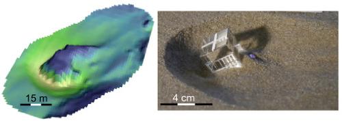
Obstacle marks are instream bedforms, typically composed of an upstream frontal scour hole and a downstream sediment accumulation in the vicinity of an obstacle. Local scouring at infrastructure (e.g. bridge piers) is a well‐studied phenomenon in hydraulic engineering, while less attention is given to the time‐dependent evolution of frontal scour holes at instream boulders and their geometric relations (depth to width, and length ratio). Furthermore, a comparison between laboratory studies and field observations is rare. Therefore, the morphodynamic importance of such scour features to fluvial sediment transport and morphological change is largely unknown. In this study, obstacle marks at boulder‐like obstructions were physically modelled in 30 unscaled process‐focused flume experiments (runtime per experiment ≥ 5760 min) at a range of flows (subcritical, clear‐water conditions, emergent and submerged water levels) and boundary conditions designed to represent the field setting (i.e. obstacle tilting, and limited thickness of the alluvial layer). Additionally, geometries of scour holes at 90 in‐situ boulders (diameter ≥ 1 m) located in a 50‐km segment of the Colorado River in Marble Canyon (AZ) were measured from a 1 m‐resolution digital elevation model. Flume experiments reveal similar evolution of local scouring, irrespective of hydraulic conditions, controlled by the scour incision, whereas the thickness of the alluvial layer and obstacle tilting into the evolving frontal scour hole limit incision. Three temporal evolution phases—(1) rapid incision, (2) decreasing incision, and (3) scour widening—are identified based on statistical analysis of spatiotemporal bed elevation time series. A quantitative model is presented that mechanistically predicts enlargement in local scour length and width based on (1) scour depth, (2) the inclination of scour slopes, and (3) the planform area of the frontal scour hole bottom. The comparison of field observations and laboratory results demonstrates scale invariance of geometry, which implies similitude of processes and form rather than equifinality.
中文翻译:

流入巨石的障碍物标记的几何形状—实验室研究和现场观察相结合
障碍物标记是上游河床形物,通常由上游额叶冲刷孔和障碍物附近的下游沉积物堆积组成。在水利工程中,基础设施(例如桥墩)的局部冲刷是一个经过充分研究的现象,而对河床巨石上的正面冲刷孔及其几何关系(深度与宽度以及长度比)的时间依赖性演变却没有给予足够的重视。 。此外,在实验室研究和现场观察之间进行比较的情况很少。因此,这种冲刷特征对河流沉积物运输和形态变化的形态动力学重要性在很大程度上是未知的。在这项研究中,在30个无标度的以过程为中心的水槽实验(每个实验的运行时间≥5760分钟)中,在一定范围的流量(亚临界,清水条件,出水和淹没水位)和为满足以下条件而设计的边界条件下,对巨石状障碍物的障碍物进行了物理建模代表场设置(即障碍物倾斜和冲积层的有限厚度)。此外,冲孔的几何形状为90原位使用1 m分辨率的数字高程模型测量了位于大理石峡谷(AZ)科罗拉多河50公里段的巨石(直径≥1 m)。水槽实验揭示了不受冲刷切口控制的局部冲刷的演变,而与水力条件无关,而冲积层的厚度和障碍物向不断演变的额叶冲刷孔极限切口的倾斜。基于时空床抬高时间序列的统计分析,确定了三个时间演变阶段:(1)快速切开,(2)切开减小和(3)冲刷扩大。提出了一种定量模型,该模型基于以下因素以机械方式预测局部冲刷长度和宽度的增大:(1)冲刷深度,(2)冲刷坡度的倾斜度和(3)正面冲刷孔底部的平面区域。
更新日期:2020-12-23
中文翻译:
流入巨石的障碍物标记的几何形状—实验室研究和现场观察相结合
障碍物标记是上游河床形物,通常由上游额叶冲刷孔和障碍物附近的下游沉积物堆积组成。在水利工程中,基础设施(例如桥墩)的局部冲刷是一个经过充分研究的现象,而对河床巨石上的正面冲刷孔及其几何关系(深度与宽度以及长度比)的时间依赖性演变却没有给予足够的重视。 。此外,在实验室研究和现场观察之间进行比较的情况很少。因此,这种冲刷特征对河流沉积物运输和形态变化的形态动力学重要性在很大程度上是未知的。在这项研究中,在30个无标度的以过程为中心的水槽实验(每个实验的运行时间≥5760分钟)中,在一定范围的流量(亚临界,清水条件,出水和淹没水位)和为满足以下条件而设计的边界条件下,对巨石状障碍物的障碍物进行了物理建模代表场设置(即障碍物倾斜和冲积层的有限厚度)。此外,冲孔的几何形状为90原位使用1 m分辨率的数字高程模型测量了位于大理石峡谷(AZ)科罗拉多河50公里段的巨石(直径≥1 m)。水槽实验揭示了不受冲刷切口控制的局部冲刷的演变,而与水力条件无关,而冲积层的厚度和障碍物向不断演变的额叶冲刷孔极限切口的倾斜。基于时空床抬高时间序列的统计分析,确定了三个时间演变阶段:(1)快速切开,(2)切开减小和(3)冲刷扩大。提出了一种定量模型,该模型基于以下因素以机械方式预测局部冲刷长度和宽度的增大:(1)冲刷深度,(2)冲刷坡度的倾斜度和(3)正面冲刷孔底部的平面区域。


 京公网安备 11010802027423号