当前位置:
X-MOL 学术
›
Earth Surf.Process. Land.
›
论文详情
Our official English website, www.x-mol.net, welcomes your feedback! (Note: you will need to create a separate account there.)
Past, present and future of a meandering river in the Bolivian Amazon basin
Earth Surface Processes and Landforms ( IF 3.3 ) Pub Date : 2020-12-22 , DOI: 10.1002/esp.5058 Kattia Rubi Arnez Ferrel 1 , Jonathan Mark Nelson 2 , Yasuyuki Shimizu 1 , Tomoko Kyuka 1
Earth Surface Processes and Landforms ( IF 3.3 ) Pub Date : 2020-12-22 , DOI: 10.1002/esp.5058 Kattia Rubi Arnez Ferrel 1 , Jonathan Mark Nelson 2 , Yasuyuki Shimizu 1 , Tomoko Kyuka 1
Affiliation
|
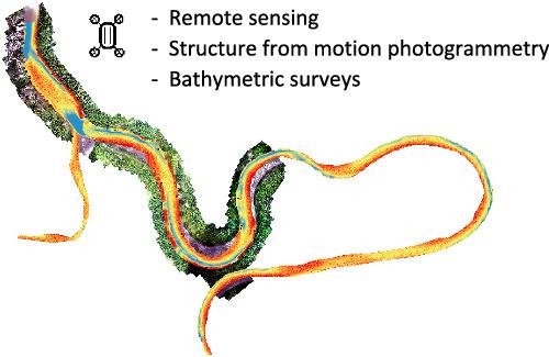
Field observations on small rivers of the Amazon basin are less common due to their remote location and difficult accessibility. Here we show, through remote sensing analysis and field works, the planform evolution and riverbed topography of a small river located in the upper foreland Amazon basin, the Ichilo River. By tracking planform changes over 30 years, we identified the factors that control meander migration rates in the Ichilo River: cutoffs, climate and human interventions. The data suggest that neck cutoffs are the main controls in the Ichilo River, with an annual density of 0.022 cutoffs/km. In addition, climate controls have been identified in the form of high‐precipitation events that may have promoted cutoffs, an increase in meander migration rate and channel widening. The width distribution of the Ichilo River is well represented by general extreme value and inverse Gaussian distributions. The spatiotemporal variability of meandering migration rates in the Ichilo River is analysed in two locations where neck cutoffs are expected. Analysing the distance across the neck in these two points, we predict the occurrence of a new cutoff. The combined methodology of bathymetric surveys and structure from motion photogrammetry shows us the Ichilo riverbed topography and banks at high resolution, where two scour holes were identified. Finally, we discuss the impact of planform changes of the Ichilo River on communities that are established along its riverbanks.
中文翻译:

玻利维亚亚马逊流域蜿蜒河流的过去,现在和未来
由于地处偏远且难以到达,在亚马逊河流域的小河上进行实地观测的情况较少。在这里,我们通过遥感分析和现场工作,展示了位于前陆亚马逊河上游流域伊希洛河的一条小河的平面演变和河床地形。通过跟踪30年来的计划变化,我们确定了控制Ichilo河曲折迁徙速率的因素:截断,气候和人为干预。数据表明,在Ichilo河中,截流是主要控制措施,年密度为0.022截流/公里。此外,已经以高降水事件的形式确定了气候控制,这些事件可能导致了临界值,弯曲迁移率增加和渠道拓宽。Ichilo河的宽度分布很好地代表了一般的极值和反高斯分布。在两个预计会截断脖子的地方,对伊希洛河中蜿蜒的迁徙速度的时空变化进行了分析。分析这两个点在脖子上的距离,我们预测会出现新的截止。水深测量和运动摄影测量的结构相结合的方法向我们展示了高分辨率的Ichilo河床地形和河岸,其中确定了两个冲孔。最后,我们讨论了Ichilo河的平面变化对沿河岸建立的社区的影响。在两个预计会截断脖子的地方,对伊希洛河中蜿蜒的迁徙速度的时空变化进行了分析。分析这两个点在脖子上的距离,我们预测会出现新的截止。水深测量和运动摄影测量的结构相结合的方法向我们展示了高分辨率的Ichilo河床地形和河岸,其中确定了两个冲孔。最后,我们讨论了Ichilo河的平面变化对沿河岸建立的社区的影响。在两个预计会截断脖子的地方,对伊希洛河中蜿蜒的迁徙速度的时空变化进行了分析。分析这两个点在脖子上的距离,我们预测会出现新的截止。水深测量和运动摄影测量的结构相结合的方法向我们展示了高分辨率的Ichilo河床地形和河岸,其中确定了两个冲孔。最后,我们讨论了Ichilo河的平面变化对沿河岸建立的社区的影响。水深测量和运动摄影测量的结构相结合的方法向我们展示了高分辨率的Ichilo河床地形和河岸,其中确定了两个冲孔。最后,我们讨论了Ichilo河的平面变化对沿河岸建立的社区的影响。水深测量和运动摄影测量的结构相结合的方法向我们展示了高分辨率的Ichilo河床地形和河岸,其中确定了两个冲孔。最后,我们讨论了Ichilo河的平面变化对沿河岸建立的社区的影响。
更新日期:2020-12-22
中文翻译:
玻利维亚亚马逊流域蜿蜒河流的过去,现在和未来
由于地处偏远且难以到达,在亚马逊河流域的小河上进行实地观测的情况较少。在这里,我们通过遥感分析和现场工作,展示了位于前陆亚马逊河上游流域伊希洛河的一条小河的平面演变和河床地形。通过跟踪30年来的计划变化,我们确定了控制Ichilo河曲折迁徙速率的因素:截断,气候和人为干预。数据表明,在Ichilo河中,截流是主要控制措施,年密度为0.022截流/公里。此外,已经以高降水事件的形式确定了气候控制,这些事件可能导致了临界值,弯曲迁移率增加和渠道拓宽。Ichilo河的宽度分布很好地代表了一般的极值和反高斯分布。在两个预计会截断脖子的地方,对伊希洛河中蜿蜒的迁徙速度的时空变化进行了分析。分析这两个点在脖子上的距离,我们预测会出现新的截止。水深测量和运动摄影测量的结构相结合的方法向我们展示了高分辨率的Ichilo河床地形和河岸,其中确定了两个冲孔。最后,我们讨论了Ichilo河的平面变化对沿河岸建立的社区的影响。在两个预计会截断脖子的地方,对伊希洛河中蜿蜒的迁徙速度的时空变化进行了分析。分析这两个点在脖子上的距离,我们预测会出现新的截止。水深测量和运动摄影测量的结构相结合的方法向我们展示了高分辨率的Ichilo河床地形和河岸,其中确定了两个冲孔。最后,我们讨论了Ichilo河的平面变化对沿河岸建立的社区的影响。在两个预计会截断脖子的地方,对伊希洛河中蜿蜒的迁徙速度的时空变化进行了分析。分析这两个点在脖子上的距离,我们预测会出现新的截止。水深测量和运动摄影测量的结构相结合的方法向我们展示了高分辨率的Ichilo河床地形和河岸,其中确定了两个冲孔。最后,我们讨论了Ichilo河的平面变化对沿河岸建立的社区的影响。水深测量和运动摄影测量的结构相结合的方法向我们展示了高分辨率的Ichilo河床地形和河岸,其中确定了两个冲孔。最后,我们讨论了Ichilo河的平面变化对沿河岸建立的社区的影响。水深测量和运动摄影测量的结构相结合的方法向我们展示了高分辨率的Ichilo河床地形和河岸,其中确定了两个冲孔。最后,我们讨论了Ichilo河的平面变化对沿河岸建立的社区的影响。


 京公网安备 11010802027423号