当前位置:
X-MOL 学术
›
Earth Surf.Process. Land.
›
论文详情
Our official English website, www.x-mol.net, welcomes your feedback! (Note: you will need to create a separate account there.)
Generation of realistic synthetic catchments to explore fine continental surface processes
Earth Surface Processes and Landforms ( IF 3.3 ) Pub Date : 2020-12-14 , DOI: 10.1002/esp.5048 Raphaël Bunel 1 , Nicolas Lecoq 1 , Yoann Copard 1 , Eric Guérin 2 , Marco Van de Wiel 3 , Nicolas Massei 1
Earth Surface Processes and Landforms ( IF 3.3 ) Pub Date : 2020-12-14 , DOI: 10.1002/esp.5048 Raphaël Bunel 1 , Nicolas Lecoq 1 , Yoann Copard 1 , Eric Guérin 2 , Marco Van de Wiel 3 , Nicolas Massei 1
Affiliation
|
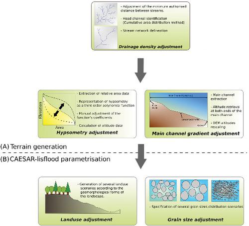
Understanding, analysing, and predicting the erosion mechanisms and sedimentary flows produced by catchments plays a key role in environmental conservation and restoration management and policies. Numerical case‐testing studies are generally undertaken to analyse the sensitivity of flood and soil erosion processes to the physical characteristics of catchments. Most analyses are conducted on simple virtual catchments with physical characteristics that, unlike real catchments, are perfectly controlled. Virtual catchments generally correspond to V‐shaped valley catchments. However, although these catchments are suitable for methodical analysis of the results, they do not provide a realistic representation of the spatial structures of the landscape and field conditions. They can, therefore, lead to potential modelling errors and can make it difficult to extend or generalize their results. Our proposed method bridges the gap between real and traditional virtual catchments by creating realistic virtual catchments with perfectly controllable physical characteristics. Our approach represents a real alternative to traditional test case procedures and provides a new framework for geomorphological and hydrological communities. It combines a field procedural generation approach, geographic information system processing procedures, and the CAESAR‐Lisflood landscape evolution model. We illustrate how each of these components acts in the process of generating virtual catchments. Five physical parameters were adjusted and tested for each virtual catchment: drainage density, hypsometric integral, mean slope of the main channel, granulometry, and land use. One of our virtual catchments is compared with a real catchment and a virtual catchment produced by a standard method. This comparison indicates that our approach can produce more realistic virtual catchments than those produced by more traditional methods, while a high degree of controllability is maintained. This new method of generating virtual catchments therefore offers significant research potential to identify the impacts of the physical characteristics of catchments on hydro‐sedimentary dynamics and responses.
中文翻译:

生成现实的合成流域,以探索精细的大陆表层过程
了解,分析和预测流域产生的侵蚀机制和沉积流在环境保护和恢复管理及政策中起着关键作用。通常进行数值案例测试研究,以分析洪水和土壤侵蚀过程对流域物理特征的敏感性。大多数分析是在具有物理特征的简单虚拟集水区上进行的,与实际集水区不同,这些特征得到了很好的控制。虚拟流域通常对应于V形山谷流域。然而,尽管这些集水区适合用于对结果进行系统的分析,但它们并不能提供景观和田间条件的空间结构的真实表示。因此,他们可以 导致潜在的建模错误,并且可能难以扩展或推广其结果。我们提出的方法通过创建具有完美可控物理特性的现实虚拟集水区来弥合真实和传统虚拟集水区之间的差距。我们的方法代表了传统测试用例程序的真正替代方法,并为地貌和水文界提供了新的框架。它结合了现场程序生成方法,地理信息系统处理程序以及CAESAR-Lisflood景观演化模型。我们将说明这些组件中的每一个在生成虚拟集水区的过程中如何起作用。针对每个虚拟集水区调整并测试了五个物理参数:排水密度,水压积分,主河道的平均坡度,粒度,和土地利用。我们将其中一个虚拟流域与一个实际流域和一个通过标准方法产生的虚拟流域进行了比较。这种比较表明,我们的方法可以产生比通过更传统的方法产生的虚拟集水区更真实的虚拟集水区,同时保持高度的可控性。因此,这种产生虚拟流域的新方法提供了巨大的研究潜力,可以识别流域的物理特征对水沉积动力学和响应的影响。
更新日期:2020-12-14
中文翻译:
生成现实的合成流域,以探索精细的大陆表层过程
了解,分析和预测流域产生的侵蚀机制和沉积流在环境保护和恢复管理及政策中起着关键作用。通常进行数值案例测试研究,以分析洪水和土壤侵蚀过程对流域物理特征的敏感性。大多数分析是在具有物理特征的简单虚拟集水区上进行的,与实际集水区不同,这些特征得到了很好的控制。虚拟流域通常对应于V形山谷流域。然而,尽管这些集水区适合用于对结果进行系统的分析,但它们并不能提供景观和田间条件的空间结构的真实表示。因此,他们可以 导致潜在的建模错误,并且可能难以扩展或推广其结果。我们提出的方法通过创建具有完美可控物理特性的现实虚拟集水区来弥合真实和传统虚拟集水区之间的差距。我们的方法代表了传统测试用例程序的真正替代方法,并为地貌和水文界提供了新的框架。它结合了现场程序生成方法,地理信息系统处理程序以及CAESAR-Lisflood景观演化模型。我们将说明这些组件中的每一个在生成虚拟集水区的过程中如何起作用。针对每个虚拟集水区调整并测试了五个物理参数:排水密度,水压积分,主河道的平均坡度,粒度,和土地利用。我们将其中一个虚拟流域与一个实际流域和一个通过标准方法产生的虚拟流域进行了比较。这种比较表明,我们的方法可以产生比通过更传统的方法产生的虚拟集水区更真实的虚拟集水区,同时保持高度的可控性。因此,这种产生虚拟流域的新方法提供了巨大的研究潜力,可以识别流域的物理特征对水沉积动力学和响应的影响。


 京公网安备 11010802027423号