当前位置:
X-MOL 学术
›
Geomorphology
›
论文详情
Our official English website, www.x-mol.net, welcomes your feedback! (Note: you will need to create a separate account there.)
River, alluvial fan and landslide interactions in a tributary junction setting: Implications for tectonic controls on Quaternary fluvial landscape development (Central Anatolian Plateau margin, Turkey)
Geomorphology ( IF 3.9 ) Pub Date : 2021-03-01 , DOI: 10.1016/j.geomorph.2020.107567 Kevin P. McClain , Cengiz Yıldırım , Attila Çiner , M. Akif Sarıkaya , Orkan Özcan , Tolga Görüm , Oğuzhan Köse , Sefa Şahin , Nafiye Güneç Kıyak , Tuğba Öztürk
Geomorphology ( IF 3.9 ) Pub Date : 2021-03-01 , DOI: 10.1016/j.geomorph.2020.107567 Kevin P. McClain , Cengiz Yıldırım , Attila Çiner , M. Akif Sarıkaya , Orkan Özcan , Tolga Görüm , Oğuzhan Köse , Sefa Şahin , Nafiye Güneç Kıyak , Tuğba Öztürk
|
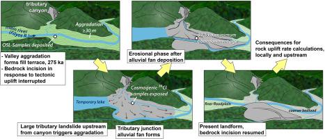
Abstract Along the western flank of the northern margin (Central Pontides) of the Central Anatolian Plateau, the humidity from the Black Sea is much higher than the central and eastern flanks and creates a complex relationship between surface and tectonic processes by triggering intense mass wasting activity and aggradation within narrow valleys. We identified three incised fill terrace levels and used Optically Stimulated Luminescence (OSL) dating to calculate fluvial sediment ages and cosmogenic 36Cl exposure dating to calculate limestone boulders exposure ages across the terrace surface. Stratigraphical interpretations and OSL ages of the lowest levels revealed that a fluvial fill terrace formed in the main valley at 275.6 ± 12.8 ka and was overlain by a main river-tributary junction alluvial fan that was abandoned at 39.5 ± 3.5 ka. The results collectively show the influence of climate, topography, hillslope processes, and lithology on aggradation-incision patterns of main rivers. Prolonged aggradation can prevent the channel equilibrium required to calculate rock uplift rates while also causing a new base-level and aggradation upstream. This effect can be exacerbated in uplifting mountainous regions with limited depositional areas. Bedrock incision rates based on the fluvial terrace age were between 0.15 and 0.2 mm/a since 39.5 ± 3.5 ka. However, the high aggradation within this segment of the main valley prevented incision of the channel bedrock for long periods, causing a potential underestimation of the rock uplift rate calculation. Our local period of aggradation appears to be related to increased aggradation and decreased bedrock incision rates measured 14 km upstream that were previously assumed to be the result of decreased tectonic uplift rates. This demonstrates the importance of corroborating strath terrace incision rate estimations with ages and incision rates of downstream fill terraces, if present, to check for potential interference with the tectonic signal.
中文翻译:

支流交汇点环境中的河流、冲积扇和滑坡相互作用:构造控制对第四纪河流景观发展的影响(土耳其安纳托利亚中部高原边缘)
摘要 在安纳托利亚中部高原北缘(中央海盆)的西翼,来自黑海的湿度远高于中部和东翼,并通过引发强烈的物质消耗活动在地表和构造过程之间产生复杂的关系。和在狭窄的山谷内聚集。我们确定了三个切开的填充阶地水平,并使用光学刺激发光 (OSL) 测年来计算河流沉积物年龄和宇宙成因 36Cl 暴露年龄来计算整个阶地表面的石灰石巨石暴露年龄。最低层的地层解释和 OSL 年龄表明,在 275.6±12.8 ka 的主要山谷中形成了一个河流填充阶地,并被一个在 39.5±3.5 ka 废弃的主要河流 - 支流交汇处冲积扇覆盖。结果综合显示了气候、地形、山坡过程和岩性对主要河流的加成切入模式的影响。延长的集层会阻止计算岩石隆起速率所需的通道平衡,同时也会导致新的基础水平和上游的集层。在沉积面积有限的隆起山区,这种影响可能会加剧。自 39.5 ± 3.5 ka 以来,基于河流阶地年龄的基岩切割速率介于 0.15 和 0.2 mm/a 之间。然而,主河谷这一段内的高地积岩长期阻止了河道基岩的切入,导致对岩石抬升速率计算的潜在低估。我们当地的加成期似乎与在上游 14 公里处测得的加成增加和基岩切入率降低有关,而这之前被认为是构造抬升率下降的结果。这证明了用年龄和下游填充阶地的切入率(如果存在)来证实地层阶地切入率估计值的重要性,以检查对构造信号的潜在干扰。
更新日期:2021-03-01
中文翻译:
支流交汇点环境中的河流、冲积扇和滑坡相互作用:构造控制对第四纪河流景观发展的影响(土耳其安纳托利亚中部高原边缘)
摘要 在安纳托利亚中部高原北缘(中央海盆)的西翼,来自黑海的湿度远高于中部和东翼,并通过引发强烈的物质消耗活动在地表和构造过程之间产生复杂的关系。和在狭窄的山谷内聚集。我们确定了三个切开的填充阶地水平,并使用光学刺激发光 (OSL) 测年来计算河流沉积物年龄和宇宙成因 36Cl 暴露年龄来计算整个阶地表面的石灰石巨石暴露年龄。最低层的地层解释和 OSL 年龄表明,在 275.6±12.8 ka 的主要山谷中形成了一个河流填充阶地,并被一个在 39.5±3.5 ka 废弃的主要河流 - 支流交汇处冲积扇覆盖。结果综合显示了气候、地形、山坡过程和岩性对主要河流的加成切入模式的影响。延长的集层会阻止计算岩石隆起速率所需的通道平衡,同时也会导致新的基础水平和上游的集层。在沉积面积有限的隆起山区,这种影响可能会加剧。自 39.5 ± 3.5 ka 以来,基于河流阶地年龄的基岩切割速率介于 0.15 和 0.2 mm/a 之间。然而,主河谷这一段内的高地积岩长期阻止了河道基岩的切入,导致对岩石抬升速率计算的潜在低估。我们当地的加成期似乎与在上游 14 公里处测得的加成增加和基岩切入率降低有关,而这之前被认为是构造抬升率下降的结果。这证明了用年龄和下游填充阶地的切入率(如果存在)来证实地层阶地切入率估计值的重要性,以检查对构造信号的潜在干扰。


 京公网安备 11010802027423号