当前位置:
X-MOL 学术
›
Ocean Coast Manage.
›
论文详情
Our official English website, www.x-mol.net, welcomes your feedback! (Note: you will need to create a separate account there.)
Analysis on the utilization and carrying capacity of coastal tidal flat in bays around the Bohai Sea
Ocean & Coastal Management ( IF 4.6 ) Pub Date : 2020-12-01 , DOI: 10.1016/j.ocecoaman.2020.105449 Tianhao Zhang , Xiaojing Niu
Ocean & Coastal Management ( IF 4.6 ) Pub Date : 2020-12-01 , DOI: 10.1016/j.ocecoaman.2020.105449 Tianhao Zhang , Xiaojing Niu
|
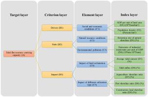
Abstract The utilization and protection of tidal flat play a crucial role in the sustainable development of coastal areas. This study aims to propose an evaluation index system model for the carrying capacity of the tidal flat resources in bays around the Bohai Sea. Indexes are selected under the framework of DSI (Drivers-State-Impact), considering the socio-economic driving factors, resource conditions, the influence of shoreline change on hydrodynamic environment and the utilization type associating with possible ecological impact. Basic indexes are quantified using publicly available statistical information, hydrodynamic numerical simulation and satellite image interpretation, while the weight of each index is determined using the entropy weight method. The historical changes and future trends of shoreline and the utilization type of the coastal tidal flat in last decades are analyzed, and the carrying capacity of the tidal flat resources around the Bohai Sea has been evaluated. The coast around the Bohai Sea is divided into three areas, the Liaodong Bay, the Bohai Bay and the Laizhou Bay. The results show that the carrying capacity of the Laizhou Bay is better than the other areas. Moreover, the carrying capacity of the three areas showed a large decline from 2003 to 2013, while the decline slowed from 2013 to 2018 and is expected to increase slightly from 2018 to 2028.
中文翻译:

环渤海海湾滨海滩涂利用与承载能力分析
摘要 滩涂的利用和保护对沿海地区的可持续发展具有至关重要的作用。本研究旨在提出环渤海海湾滩涂资源承载力评价指标体系模型。在DSI(Drivers-State-Impact)框架下,综合考虑社会经济驱动因素、资源条件、海岸线变化对水动力环境的影响以及与可能的生态影响相关的利用类型,选取指标。基本指标采用公开统计信息、水动力数值模拟和卫星图像解译量化,各指标权重采用熵权法确定。分析了近十年来海岸线的历史变化和未来趋势以及滨海滩涂利用类型,评价了环渤海滩涂资源的承载能力。环渤海沿岸分为辽东湾、渤海湾和莱州湾三个区域。结果表明,莱州湾的承载能力优于其他地区。而且,3个区域的承载能力在2003-2013年呈现较大下降,而2013-2018年下降趋势放缓,预计2018-2028年将小幅提升。渤海湾和莱州湾。结果表明,莱州湾的承载能力优于其他地区。而且,3个区域的承载能力在2003-2013年呈现较大下降,而2013-2018年下降趋势放缓,预计2018-2028年将小幅提升。渤海湾和莱州湾。结果表明,莱州湾的承载能力优于其他地区。而且,3个区域的承载能力在2003-2013年呈现较大下降,而2013-2018年下降趋势放缓,预计2018-2028年将小幅提升。
更新日期:2020-12-01
中文翻译:
环渤海海湾滨海滩涂利用与承载能力分析
摘要 滩涂的利用和保护对沿海地区的可持续发展具有至关重要的作用。本研究旨在提出环渤海海湾滩涂资源承载力评价指标体系模型。在DSI(Drivers-State-Impact)框架下,综合考虑社会经济驱动因素、资源条件、海岸线变化对水动力环境的影响以及与可能的生态影响相关的利用类型,选取指标。基本指标采用公开统计信息、水动力数值模拟和卫星图像解译量化,各指标权重采用熵权法确定。分析了近十年来海岸线的历史变化和未来趋势以及滨海滩涂利用类型,评价了环渤海滩涂资源的承载能力。环渤海沿岸分为辽东湾、渤海湾和莱州湾三个区域。结果表明,莱州湾的承载能力优于其他地区。而且,3个区域的承载能力在2003-2013年呈现较大下降,而2013-2018年下降趋势放缓,预计2018-2028年将小幅提升。渤海湾和莱州湾。结果表明,莱州湾的承载能力优于其他地区。而且,3个区域的承载能力在2003-2013年呈现较大下降,而2013-2018年下降趋势放缓,预计2018-2028年将小幅提升。渤海湾和莱州湾。结果表明,莱州湾的承载能力优于其他地区。而且,3个区域的承载能力在2003-2013年呈现较大下降,而2013-2018年下降趋势放缓,预计2018-2028年将小幅提升。


 京公网安备 11010802027423号