当前位置:
X-MOL 学术
›
Remote Sens. Ecol. Conserv.
›
论文详情
Our official English website, www.x-mol.net, welcomes your feedback! (Note: you will need to create a separate account there.)
Cloud-native seascape mapping of Mozambique’s Quirimbas National Park with Sentinel-2
Remote Sensing in Ecology and Conservation ( IF 5.5 ) Pub Date : 2020-11-29 , DOI: 10.1002/rse2.187 Dimitris Poursanidis 1 , Dimosthenis Traganos 2 , Luisa Teixeira 3 , Aurélie Shapiro 4 , Lara Muaves 5
Remote Sensing in Ecology and Conservation ( IF 5.5 ) Pub Date : 2020-11-29 , DOI: 10.1002/rse2.187 Dimitris Poursanidis 1 , Dimosthenis Traganos 2 , Luisa Teixeira 3 , Aurélie Shapiro 4 , Lara Muaves 5
Affiliation
|
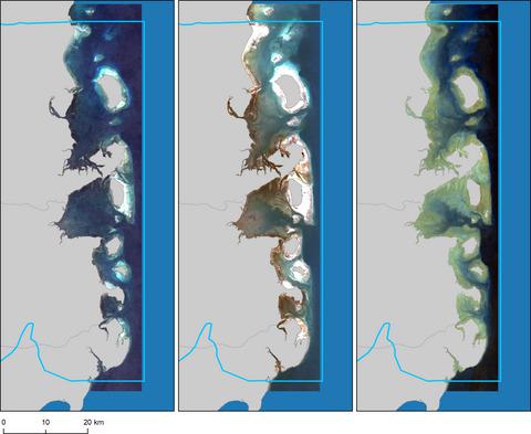
The lack of detailed spatial information on coastal resources, notably shallow water coral reefs and associated benthic habitats, impedes our ability to protect and manage them in the face of global climate change and anthropogenic impacts. Here, we develop a semi-automated workflow in the cloud that uses freely available Sentinel-2 data from the European Space Agency (ESA) Copernicus programme to derive information on near-shore coral reef habitats in the Quirimbas National Park (QNP), a recently declared biosphere reserve in northern Mozambique. We use an end-to-end cloud-based framework within the Google Earth Engine cloud geospatial platform to process imagery from raw pixels to cloud-free composites which are corrected for glint and surface artefacts, water column and derived estimated depth and then classified into four benthic habitats. Using independent training and validation data, we apply three supervised classification algorithms: random forests (RF), support vector machine (SVM) and classification and regression trees (CART). Our results show that random forests are the most accurate supervised algorithm with over 82% overall accuracy. We mapped over 105 000 ha of shallow water habitat inside the protected area, of which 18% are dominated by coral and hardbottom; 27.5% are seagrass and submerged aquatic vegetation and another 23.4% are soft and sandy substrates, and the remaining area is optically deep water. We employ satellite-derived bathymetry to assess slope, bathymetric position, rugosity and underwater topography of these habitats. Finally, a spectral unmixing model provides further sub-pixel–level information of habitats with the potential to monitor changes over time. This effort provides the first, consistent and repeatable and also scalable coastal information system for an east African tropical marine protected area, which hosts shallow-water ecosystems which are of great significance to local communities and building resilience towards climate change.
中文翻译:

使用 Sentinel-2 绘制莫桑比克 Quirimbas 国家公园的云原生海景图
缺乏关于沿海资源的详细空间信息,特别是浅水珊瑚礁和相关的底栖栖息地,阻碍了我们在面对全球气候变化和人为影响时保护和管理它们的能力。在这里,我们在云中开发了一个半自动化工作流程,该工作流程使用来自欧洲航天局 (ESA) 哥白尼计划的免费可用 Sentinel-2 数据来获取有关基林巴斯国家公园 (QNP) 近岸珊瑚礁栖息地的信息,最近在莫桑比克北部宣布了生物圈保护区。我们在 Google Earth Engine 云地理空间平台中使用端到端的基于云的框架来处理从原始像素到无云合成的图像,这些合成经过闪烁和表面伪影、水柱和导出的估计深度校正,然后分类为四个底栖栖息地。使用独立的训练和验证数据,我们应用了三种监督分类算法:随机森林 (RF)、支持向量机 (SVM) 以及分类和回归树 (CART)。我们的结果表明,随机森林是最准确的监督算法,总体准确率超过 82%。我们在保护区内绘制了超过 105 000 公顷的浅水栖息地,其中 18% 以珊瑚和硬底为主;27.5% 是海草和淹没水生植被,另外 23.4% 是柔软的沙质基质,其余区域是光学深水。我们采用卫星衍生的测深技术来评估这些栖息地的坡度、测深位置、粗糙度和水下地形。最后,光谱分离模型提供了栖息地的进一步亚像素级信息,有可能监测随时间的变化。这项工作为东非热带海洋保护区提供了第一个、一致、可重复且可扩展的沿海信息系统,该保护区拥有浅水生态系统,这对当地社区和建立对气候变化的适应能力具有重要意义。
更新日期:2020-11-29
中文翻译:
使用 Sentinel-2 绘制莫桑比克 Quirimbas 国家公园的云原生海景图
缺乏关于沿海资源的详细空间信息,特别是浅水珊瑚礁和相关的底栖栖息地,阻碍了我们在面对全球气候变化和人为影响时保护和管理它们的能力。在这里,我们在云中开发了一个半自动化工作流程,该工作流程使用来自欧洲航天局 (ESA) 哥白尼计划的免费可用 Sentinel-2 数据来获取有关基林巴斯国家公园 (QNP) 近岸珊瑚礁栖息地的信息,最近在莫桑比克北部宣布了生物圈保护区。我们在 Google Earth Engine 云地理空间平台中使用端到端的基于云的框架来处理从原始像素到无云合成的图像,这些合成经过闪烁和表面伪影、水柱和导出的估计深度校正,然后分类为四个底栖栖息地。使用独立的训练和验证数据,我们应用了三种监督分类算法:随机森林 (RF)、支持向量机 (SVM) 以及分类和回归树 (CART)。我们的结果表明,随机森林是最准确的监督算法,总体准确率超过 82%。我们在保护区内绘制了超过 105 000 公顷的浅水栖息地,其中 18% 以珊瑚和硬底为主;27.5% 是海草和淹没水生植被,另外 23.4% 是柔软的沙质基质,其余区域是光学深水。我们采用卫星衍生的测深技术来评估这些栖息地的坡度、测深位置、粗糙度和水下地形。最后,光谱分离模型提供了栖息地的进一步亚像素级信息,有可能监测随时间的变化。这项工作为东非热带海洋保护区提供了第一个、一致、可重复且可扩展的沿海信息系统,该保护区拥有浅水生态系统,这对当地社区和建立对气候变化的适应能力具有重要意义。


 京公网安备 11010802027423号