当前位置:
X-MOL 学术
›
Mar. Petrol. Geol.
›
论文详情
Our official English website, www.x-mol.net, welcomes your feedback! (Note: you will need to create a separate account there.)
Seeing beyond the outcrop: Integration of ground-penetrating radar with digital outcrop models of a paleokarst system
Marine and Petroleum Geology ( IF 4.2 ) Pub Date : 2021-03-01 , DOI: 10.1016/j.marpetgeo.2020.104833 Julian Janocha , Aleksandra Smyrak-Sikora , Kim Senger , Thomas Birchall
Marine and Petroleum Geology ( IF 4.2 ) Pub Date : 2021-03-01 , DOI: 10.1016/j.marpetgeo.2020.104833 Julian Janocha , Aleksandra Smyrak-Sikora , Kim Senger , Thomas Birchall
|
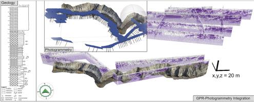
Abstract Paleokarst breccias are a common feature of sedimentary rift basins. The Billefjorden Trough in the high Arctic archipelago of Svalbard is an example of such a rift. Here the Carboniferous stratigraphy exhibits intervals of paleokarst breccias formed by gypsum dissolution. In this study we integrate digital outcrop models (DOMs) with a 2D ground penetrating radar (GPR) survey, to extrapolate external irregular paleokarst geometries beyond the two-dimensional outcrops. DOMs are obtained through combining a series of overlapping photographs with structure-from-motion photogrammetry, to create mm-to cm-resolution georeferenced DOM's. GPR is typically used for surveying the shallow subsurface and relies on detecting the contrasts in electro-magnetic permittivity. We defined three geophysical facies based on their appearance in GPR. Integrating subsurface geophysical data with DOMs enables the correlation of reflection patterns in GPR with outcrop features. The chaotic nature of paleokarst breccias is seen both in outcrop and GPR. Key horizons in outcrop and the GPR profiles allow tying together observations between these methods. Furthermore, we show that this technique expands the two-dimensional outcrop surface into a three-dimensional domain, thus complementing, strengthening and extending outcrop interpretations.
中文翻译:

超越露头:探地雷达与古岩溶系统数字露头模型的集成
摘要 古岩溶角砾岩是沉积裂谷盆地的共同特征。位于斯瓦尔巴群岛北极群岛的比勒峡湾海槽就是这种裂谷的一个例子。这里石炭纪地层显示出由石膏溶解形成的古岩溶角砾岩层。在这项研究中,我们将数字露头模型 (DOM) 与二维探地雷达 (GPR) 调查相结合,以推断二维露头之外的外部不规则古岩溶几何形状。DOM 是通过将一系列重叠照片与来自运动的结构摄影测量相结合而获得的,以创建毫米到厘米分辨率的地理参考 DOM。GPR 通常用于测量浅层地下,并依赖于检测电磁介电常数的对比。我们根据它们在 GPR 中的外观定义了三个地球物理相。将地下地球物理数据与 DOM 相结合,可以将 GPR 中的反射模式与露头特征相关联。在露头和探地雷达中都可以看到古岩溶角砾岩的混沌性质。露头中的关键层位和 GPR 剖面允许将这些方法之间的观测联系在一起。此外,我们表明该技术将二维露头表面扩展到三维域,从而补充、加强和扩展露头解释。
更新日期:2021-03-01
中文翻译:
超越露头:探地雷达与古岩溶系统数字露头模型的集成
摘要 古岩溶角砾岩是沉积裂谷盆地的共同特征。位于斯瓦尔巴群岛北极群岛的比勒峡湾海槽就是这种裂谷的一个例子。这里石炭纪地层显示出由石膏溶解形成的古岩溶角砾岩层。在这项研究中,我们将数字露头模型 (DOM) 与二维探地雷达 (GPR) 调查相结合,以推断二维露头之外的外部不规则古岩溶几何形状。DOM 是通过将一系列重叠照片与来自运动的结构摄影测量相结合而获得的,以创建毫米到厘米分辨率的地理参考 DOM。GPR 通常用于测量浅层地下,并依赖于检测电磁介电常数的对比。我们根据它们在 GPR 中的外观定义了三个地球物理相。将地下地球物理数据与 DOM 相结合,可以将 GPR 中的反射模式与露头特征相关联。在露头和探地雷达中都可以看到古岩溶角砾岩的混沌性质。露头中的关键层位和 GPR 剖面允许将这些方法之间的观测联系在一起。此外,我们表明该技术将二维露头表面扩展到三维域,从而补充、加强和扩展露头解释。


 京公网安备 11010802027423号