International Journal of Applied Earth Observation and Geoinformation ( IF 7.5 ) Pub Date : 2020-11-05 , DOI: 10.1016/j.jag.2020.102254 Yu Li , Meiling Liu , Xiangnan Liu , Wenfu Yang , Wenwen Wang
|
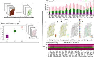
The analysis of change processes in relation to spatial patterns is gaining increasing attention in landscape ecology. Forest spatial pattern change is a critical process in landscape dynamics, and has a significant impact on the biodiversity, habitat quality, and ultimately, variation in the overall function of a forest ecosystem. The purpose of this study is to characterise the forest spatial pattern evolution over a 1 × 1 km2 landscape units covering Shanxi, which is a major coal-energy province in northern China. Four landscape metrics, i.e., aggregation index (AI), largest patch index (LPI), patch density (PD), and shape index (SI), were derived based upon annual forest distribution maps (1987–2018). These metrics were used to identify three spatially heterogeneous pattern types: severely fragmentised pattern (SFP), incompletely fragmentised pattern (IFP), and relatively intact pattern (RIP), based on the integration of the self-organising map (SOM) with k-means algorithms. Post-classification change detection was conducted to analyse the change process of the forest spatial patterns. Results indicate that:(i) the average proportion of forest area with the RIP was approximately 50%, making it the dominant spatial pattern type; whereas forest areas with the SFP and IFP gradually approached each other in value; (ii) 80.7% landscape units experienced a pattern change, wherein the area with the SFP was always more likely to disappear during transition; (iii) Therein, the change times primarily concentrated between 2 and 4 for 66% of these units and the change duration was primarily in the range of 7–17 years. A relatively high proportion of pattern change occurred for sequential periods (2002–2005), and that the IFP interacts with the other pattern types most frequently. We concluded that the evaluation of multiple landscape metrics is effective in identifying spatial patterns through the combined use of the SOM with the k-means cluster. The spatial pattern and landscape change processes are mutually restricted, and the forest spatial pattern has its own internal dynamics that has a different effect on the change processes.


 京公网安备 11010802027423号