International Journal of Applied Earth Observation and Geoinformation ( IF 7.5 ) Pub Date : 2020-10-30 , DOI: 10.1016/j.jag.2020.102253 Sergii Skakun , Eric F. Vermote , Andres Eduardo Santamaria Artigas , William H. Rountree , Jean-Claude Roger
|
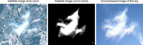
Availability of a reliable cloud mask for optical satellite imagery is a prerequisite, when generating high-quality high-level geoinformation products. Creation of a reference (ground truth) cloud mask for moderate spatial resolution sensors, such as Operational Land Imager (OLI) aboard Landsat 8 and Multispectral Instrument (MSI) aboard Sentinel-2A/B satellites, is a challenging and time-consuming task. Existing reference datasets were mainly produced through photointerpretation of satellite images by an analyst, which can introduce subjectivity in detecting clouds. Therefore, other methods for generating cloud reference data shall be explored and evaluated that can complement existing datasets. In this paper, we document generation and provide the description of a new reference cloud dataset, named GSFC-Cloud, which is based on the extensive use of ground-based images of the sky. The dataset is collected over the same area, covers various cloud conditions, and is available for six Landsat 8 and twenty-eight Sentinel-2 scenes spanning the period of September 2017 to November 2018. The dataset is available in the vector format, so cloud masks at various spatial resolutions can be validated. We also describe a system to automate the process of ground-based data collection using low-cost off-the-shelf parts with the long-term objective to replicate this set-up in multiple locations around the world. We use the proposed dataset to validate and improve the Land Surface Reflectance Code (LaSRC) for cloud detection in Sentinel-2 imagery. We show that adding a parallax feature to estimate a subpixel shift between red and green bands with a phase correlation method can reduce overdetection of clouds and improve performance of LaSRC.
中文翻译:
来自NASA GSFC的Sentinel-2和Landsat 8卫星的实验性天空图像云验证数据集
在生成高质量的高级地理信息产品时,必须具备可用于光学卫星图像的可靠云掩模。为中等空间分辨率传感器(例如Landsat 8上的Operational Land Imager(OLI)和Sentinel-2A / B卫星上的多光谱仪器(MSI))创建参考(地面真相)云遮罩是一项艰巨而费时的任务。现有参考数据集主要是通过分析师对卫星图像的光解来产生的,这可以在检测云时引入主观性。因此,应探索和评估可以补充现有数据集的其他生成云参考数据的方法。在本文中,我们记录了生成过程并提供了一个新的参考云数据集GSFC-Cloud的描述,这是基于广泛使用天空的地面图像。该数据集收集在同一区域,涵盖各种云条件,可用于2017年9月至2018年11月期间的六个Landsat 8和28个Sentinel-2场景。该数据集具有矢量格式,因此为云可以验证各种空间分辨率的光罩。我们还描述了一种系统,该系统使用低成本现成的零件来自动化地面数据收集过程,其长期目标是在全球多个地方复制此设置。我们使用提出的数据集来验证和改进用于在Sentinel-2影像中进行云检测的陆地表面反射率代码(LaSRC)。


 京公网安备 11010802027423号