当前位置:
X-MOL 学术
›
Earth Planets Space
›
论文详情
Our official English website, www.x-mol.net, welcomes your feedback! (Note: you will need to create a separate account there.)
Anatomy of active volcanic edifice at the Kusatsu–Shirane volcano, Japan, by magnetotellurics: hydrothermal implications for volcanic unrests
Earth, Planets and Space ( IF 3.362 ) Pub Date : 2020-10-23 , DOI: 10.1186/s40623-020-01283-2 Kuo Hsuan Tseng , Yasuo Ogawa , Nurhasan , Sabri Bülent Tank , Naoto Ujihara , Yoshimori Honkura , Akihiko Terada , Yoshiya Usui , Wataru Kanda
Earth, Planets and Space ( IF 3.362 ) Pub Date : 2020-10-23 , DOI: 10.1186/s40623-020-01283-2 Kuo Hsuan Tseng , Yasuo Ogawa , Nurhasan , Sabri Bülent Tank , Naoto Ujihara , Yoshimori Honkura , Akihiko Terada , Yoshiya Usui , Wataru Kanda
|
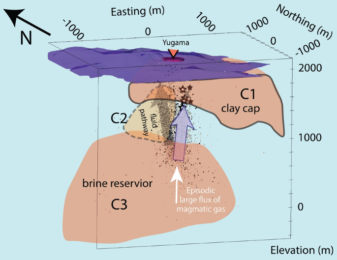
We aimed to perform three-dimensional imaging of the underlying geothermal system to a depth of 2 km using magnetotellurics (MT) at around the Yugama crater, the Kusatsu–Shirane Volcano, Japan, which is known to have frequent phreatic eruptions. We deployed 91 MT sites focusing around the peak area of 2 km × 2 km with typical spacings of 200 m. The full tensor impedances and the magnetic transfer functions were inverted, using an unstructured tetrahedral finite element code to include the topographic effect. The final model showed (1) low-permeability bell-shaped clay cap (C1) as the near-surface conductor, (2) brine reservoir as a deep conductor (C3) at a depth of 1.5 km from the surface, and (3) a vertical conductor (C2) connecting the deep conductor to the clay cap which implies an established fluid path. The columnar high-seismicity distribution to the east of the C2 conductor implies that the flushed vapor and magmatic gas was released from the brine reservoir by breaking the silica cap at the brittle–ductile transition. The past magnetization/demagnetization sources and the inflation source of the 2014 unrest are located just below the clay cap, consistent with the clay capped geothermal model underlain by brine reservoir. The resistivity model showed the architecture of the magmatic–hydrothermal system, which can explain the episodic volcanic unrest.
中文翻译:

大地电磁学对日本草津-白根火山活动火山结构的解剖:热液对火山动乱的影响
我们的目标是使用大地电磁学 (MT) 在日本草津 - 白根火山附近的地下地热系统进行 2 公里深度的三维成像,众所周知,该火山经常发生潜水喷发。我们部署了 91 个 MT 站点,重点围绕 2 km × 2 km 的峰区,典型间距为 200 m。完整的张量阻抗和磁传递函数被反转,使用非结构化四面体有限元代码来包括地形效应。最终模型显示 (1) 低渗透钟形粘土帽 (C1) 作为近地表导体,(2) 盐水储层作为距离地表 1.5 公里深处的深导体 (C3),以及 (3 ) 垂直导体 (C2) 将深导体连接到粘土帽,这意味着已建立的流体路径。C2 导体以东的柱状高地震分布意味着冲刷的蒸汽和岩浆气是通过在脆-韧转变处打破二氧化硅盖而从卤水储层中释放出来的。过去的磁化/退磁源和 2014 年动乱的膨胀源位于粘土盖下方,与盐水储层下方的粘土盖地热模型一致。电阻率模型显示了岩浆-热液系统的结构,可以解释间歇性火山动荡。过去的磁化/退磁源和 2014 年动乱的膨胀源位于粘土盖下方,与盐水储层下方的粘土盖地热模型一致。电阻率模型显示了岩浆-热液系统的结构,可以解释间歇性火山动荡。过去的磁化/退磁源和 2014 年动乱的膨胀源位于粘土盖下方,与盐水储层下方的粘土盖地热模型一致。电阻率模型显示了岩浆-热液系统的结构,可以解释间歇性火山动荡。
更新日期:2020-10-23
中文翻译:
大地电磁学对日本草津-白根火山活动火山结构的解剖:热液对火山动乱的影响
我们的目标是使用大地电磁学 (MT) 在日本草津 - 白根火山附近的地下地热系统进行 2 公里深度的三维成像,众所周知,该火山经常发生潜水喷发。我们部署了 91 个 MT 站点,重点围绕 2 km × 2 km 的峰区,典型间距为 200 m。完整的张量阻抗和磁传递函数被反转,使用非结构化四面体有限元代码来包括地形效应。最终模型显示 (1) 低渗透钟形粘土帽 (C1) 作为近地表导体,(2) 盐水储层作为距离地表 1.5 公里深处的深导体 (C3),以及 (3 ) 垂直导体 (C2) 将深导体连接到粘土帽,这意味着已建立的流体路径。C2 导体以东的柱状高地震分布意味着冲刷的蒸汽和岩浆气是通过在脆-韧转变处打破二氧化硅盖而从卤水储层中释放出来的。过去的磁化/退磁源和 2014 年动乱的膨胀源位于粘土盖下方,与盐水储层下方的粘土盖地热模型一致。电阻率模型显示了岩浆-热液系统的结构,可以解释间歇性火山动荡。过去的磁化/退磁源和 2014 年动乱的膨胀源位于粘土盖下方,与盐水储层下方的粘土盖地热模型一致。电阻率模型显示了岩浆-热液系统的结构,可以解释间歇性火山动荡。过去的磁化/退磁源和 2014 年动乱的膨胀源位于粘土盖下方,与盐水储层下方的粘土盖地热模型一致。电阻率模型显示了岩浆-热液系统的结构,可以解释间歇性火山动荡。


 京公网安备 11010802027423号