当前位置:
X-MOL 学术
›
Earth Surf.Process. Land.
›
论文详情
Our official English website, www.x-mol.net, welcomes your feedback! (Note: you will need to create a separate account there.)
Impact of an 0.2 km3 Rock Avalanche on Lake Eibsee (Bavarian Alps, Germany) – Part I: Reconstruction of the paleolake and Effects of the Impact
Earth Surface Processes and Landforms ( IF 3.3 ) Pub Date : 2020-10-17 , DOI: 10.1002/esp.5024 Sibylle Knapp 1 , Philipp Mamot 1 , Bernhard Lempe 2 , Michael Krautblatter 1
Earth Surface Processes and Landforms ( IF 3.3 ) Pub Date : 2020-10-17 , DOI: 10.1002/esp.5024 Sibylle Knapp 1 , Philipp Mamot 1 , Bernhard Lempe 2 , Michael Krautblatter 1
Affiliation
|
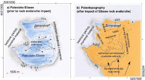
Rock avalanches destroy and reshape landscapes in only a few minutes and are among the most hazardous processes on Earth. The surface morphology of rock avalanche deposits and the interaction with the underlying material are crucial for runout properties and reach. Water within the travel path is displaced, producing large impact waves and reducing friction, leading to long runouts. We hypothesize that the 0.2 km3 Holocene Eibsee rock avalanche from Mount Zugspitze in the Bavarian Alps overran and destroyed Paleolake Eibsee and left a unique sedimentological legacy of processes active during the landslide. We captured 9.5 km of electrical resistivity tomography (ERT) profiles across the rock avalanche deposits, with up to 120 m penetration depth and more than 34 000 datum points. The ERT profiles reveal up to ~50 m thick landslide debris, locally covering up to ~30 m of rock debris with entrained fine‐grained sediments on top of isolated remnants of decametre‐wide paleolake sediments. The ERT profiles allow us to infer processes involved in the interaction of the rock avalanche with bedrock, lake sediments, and morainal sediments, including shearing, bulging, and bulldozing. Complementary data from drilling, a gravel pit exposure, laboratory tests, and geomorphic features were used for ERT calibration. Sediments overrun by the rock avalanche show water‐escape structures. Based on all of these datasets, we reconstructed both position and size of the paleolake prior to the catastrophic event. Our reconstruction of the event contributes to process an understanding of the rock avalanche and future modelling and hazard assessment. Here we show how integrated geomorphic, geophysical, and sedimentological approaches can provide detailed insights into the impact of a rock avalanche on a lake. © 2020 The Authors. Earth Surface Processes and Landforms published by John Wiley & Sons Ltd
中文翻译:

0.2 km3的岩石雪崩对艾比湖(德国巴伐利亚阿尔卑斯山)的影响–第一部分:古湖的重建及其影响
岩石雪崩仅需几分钟即可破坏和重塑景观,是地球上最危险的过程之一。岩石雪崩沉积物的表面形态以及与下伏物质的相互作用对于跳动特性和覆盖范围至关重要。行进路径中的水被置换,产生大的冲击波并减少摩擦,导致长跳动。我们假设0.2 km 3来自巴伐利亚阿尔卑斯山祖格峰山的全新世Eibsee岩石雪崩覆盖并摧毁了Paleolake Eibsee,留下了滑坡过程中活跃的独特的沉积学遗产。我们在岩石雪崩沉积层上捕获了9.5 km的电阻层析成像(ERT)剖面,穿透深度达120 m,基准点超过34000。ERT剖面揭示了厚约50 m的滑坡碎屑,局部覆盖了厚约30 m的岩石碎屑,其中夹杂着细粒沉积物,覆盖着十米级的古石质沉积物。ERT剖面使我们可以推断出雪崩与基岩,湖泊沉积物和排水沉积物相互作用的过程,包括剪切,凸起和推土。来自钻孔,砾石坑暴露,实验室测试的补充数据,和地貌特征用于ERT校准。被岩石雪崩冲刷的沉积物显示出水流逸散结构。基于所有这些数据集,我们在发生灾难性事件之前重建了古湖的位置和大小。我们对活动的重建有助于对岩石雪崩的了解以及将来的建模和危害评估。在这里,我们展示了整合的地貌,地球物理和沉积学方法如何能够提供关于岩石雪崩对湖的影响的详细见解。©2020作者。约翰·威利父子有限公司出版的《地球表面过程和地形》在灾难性事件发生之前,我们重建了古湖的位置和大小。我们对活动的重建有助于对岩石雪崩的了解以及将来的建模和危害评估。在这里,我们展示了整合的地貌,地球物理和沉积学方法如何能够提供关于岩石雪崩对湖的影响的详细见解。©2020作者。约翰·威利父子有限公司出版的《地球表面过程和地形》在灾难性事件发生之前,我们重建了古湖的位置和大小。我们对活动的重建有助于对岩石雪崩的了解以及将来的建模和危害评估。在这里,我们展示了整合的地貌,地球物理和沉积学方法如何能够提供关于岩石雪崩对湖的影响的详细见解。©2020作者。约翰·威利父子有限公司出版的《地球表面过程和地形》
更新日期:2020-10-17
中文翻译:
0.2 km3的岩石雪崩对艾比湖(德国巴伐利亚阿尔卑斯山)的影响–第一部分:古湖的重建及其影响
岩石雪崩仅需几分钟即可破坏和重塑景观,是地球上最危险的过程之一。岩石雪崩沉积物的表面形态以及与下伏物质的相互作用对于跳动特性和覆盖范围至关重要。行进路径中的水被置换,产生大的冲击波并减少摩擦,导致长跳动。我们假设0.2 km 3来自巴伐利亚阿尔卑斯山祖格峰山的全新世Eibsee岩石雪崩覆盖并摧毁了Paleolake Eibsee,留下了滑坡过程中活跃的独特的沉积学遗产。我们在岩石雪崩沉积层上捕获了9.5 km的电阻层析成像(ERT)剖面,穿透深度达120 m,基准点超过34000。ERT剖面揭示了厚约50 m的滑坡碎屑,局部覆盖了厚约30 m的岩石碎屑,其中夹杂着细粒沉积物,覆盖着十米级的古石质沉积物。ERT剖面使我们可以推断出雪崩与基岩,湖泊沉积物和排水沉积物相互作用的过程,包括剪切,凸起和推土。来自钻孔,砾石坑暴露,实验室测试的补充数据,和地貌特征用于ERT校准。被岩石雪崩冲刷的沉积物显示出水流逸散结构。基于所有这些数据集,我们在发生灾难性事件之前重建了古湖的位置和大小。我们对活动的重建有助于对岩石雪崩的了解以及将来的建模和危害评估。在这里,我们展示了整合的地貌,地球物理和沉积学方法如何能够提供关于岩石雪崩对湖的影响的详细见解。©2020作者。约翰·威利父子有限公司出版的《地球表面过程和地形》在灾难性事件发生之前,我们重建了古湖的位置和大小。我们对活动的重建有助于对岩石雪崩的了解以及将来的建模和危害评估。在这里,我们展示了整合的地貌,地球物理和沉积学方法如何能够提供关于岩石雪崩对湖的影响的详细见解。©2020作者。约翰·威利父子有限公司出版的《地球表面过程和地形》在灾难性事件发生之前,我们重建了古湖的位置和大小。我们对活动的重建有助于对岩石雪崩的了解以及将来的建模和危害评估。在这里,我们展示了整合的地貌,地球物理和沉积学方法如何能够提供关于岩石雪崩对湖的影响的详细见解。©2020作者。约翰·威利父子有限公司出版的《地球表面过程和地形》


 京公网安备 11010802027423号