ISPRS Journal of Photogrammetry and Remote Sensing ( IF 12.7 ) Pub Date : 2020-10-09 , DOI: 10.1016/j.isprsjprs.2020.09.002 Richard K. Slocum , Christopher E. Parrish , Chase H. Simpson
|
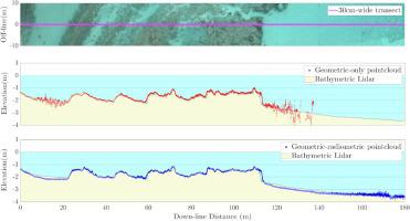
There is a pressing need for shallow bathymetry in regions around the world, including in fragile marine ecosystems, such as coral reefs. Unfortunately, mapping these shallow-water areas using in situ or boat-based methods is expensive, time consuming, and potentially dangerous, due to the need to put personnel and/or boats in high-energy nearshore areas, which may contain rocks, reefs, and other submerged hazards. For this reason, passive remote sensing methods of shallow bathymetric mapping have been rapidly growing in interest and usage. Two general categories of approaches using passive imaging can be distinguished as: (1) those based on geometry (stereo-photogrammetry); (2) those based on radiometry (attenuation of light in the water column). These two broad categories of approaches have been tested on imagery collected using aircraft and satellites in numerous previous studies. Recent work within the geometric category includes processing unmanned aircraft system (UAS) imagery using Structure from Motion and Multi-View Stereo (SfM-MVS) photogrammetry, while radiometric methods encompass the broad range of spectral bathymetry retrieval algorithms. Each broad approach category has advantages and disadvantages. Fortunately, the geometric and radiometric approaches are highly complementary. The geometric approaches tend to work best in areas of high bottom texture, which facilitates feature matching in the SfM-MVS software. Meanwhile, the radiometric approaches work best in relatively homogeneous bottom types. To leverage the strengths of each type of approach and overcome their respective weaknesses, this work develops and tests a combined geometric-radiometric bathymetric mapping approach designed for shallow-water mapping from UAS imagery. Four radiometric models of varying complexity are tested, ranging from a color-based lookup table approach to neural networks. Two UAS flights on Buck Island, off St Croix in the U.S. Virgin Islands (USVI), are used to assess the accuracy of the methodology when compared to aerial bathymetric lidar data. The results show that the combined geometric-radiometric approach provides an increase in spatial coverage of up to 61% and improvement (i.e. decrease) in 95th percentile error of up to 49% when compared to traditional refraction-corrected SfM-MVS bathymetry.
中文翻译:
结合几何放射线和神经网络方法的UAS影像进行浅水深测绘
在世界各地,包括在脆弱的海洋生态系统(例如珊瑚礁)中,迫切需要进行浅海测深。不幸的是,使用原位绘制这些浅水区域的地图由于需要将人员和/或船只放置在可能包含岩石,礁石和其他淹没危险的高能量近海区域中,因此基于船的方法昂贵,费时且有潜在危险。由于这个原因,浅水深测绘的无源遥感方法在人们的兴趣和使用中迅速增长。使用被动成像的方法可分为两大类:(1)基于几何的方法(立体摄影测量法);(2)那些基于放射(水柱中光的衰减)的辐射。在先前的许多研究中,已经对使用飞机和卫星收集的图像测试了这两种主要方法。几何类别中的最新工作包括使用运动和多视立体结构(SfM-MVS)摄影测量法处理无人机系统(UAS)图像,而放射测量方法则涵盖了光谱测深检索算法的广泛范围。每个广泛的方法类别都有优点和缺点。幸运的是,几何方法和辐射测量方法是高度互补的。几何方法往往在高底部纹理区域中效果最好,这有助于SfM-MVS软件中的特征匹配。同时,辐射法在相对均质的底部类型中效果最好。要利用每种方法的优势并克服各自的劣势,这项工作开发并测试了一种组合的几何辐射测深测绘方法,该方法专为从UAS影像进行浅水测绘而设计。从基于颜色的查找表方法到神经网络,测试了四种复杂度不同的辐射模型。与空中测深激光雷达数据相比,在美属维尔京群岛(USVI)的圣克鲁瓦(St Croix)附近的巴克岛(Buck Island)上进行的两次UAS航班评估方法的准确性。结果表明,与传统的折射校正SfM-MVS测深法相比,组合的几何放射线方法可提供高达61%的空间覆盖率增加,并提高(即减少)高达49%的95%百分率误差。与空中测深激光雷达数据相比,在美属维尔京群岛(USVI)的圣克鲁瓦(St Croix)附近的巴克岛(Buck Island)上进行的两次UAS航班评估方法的准确性。结果表明,与传统的折射校正SfM-MVS测深法相比,组合的几何放射线方法可提供高达61%的空间覆盖率增加,并提高(即减少)高达49%的95%百分率误差。与空中测深激光雷达数据相比,在美属维尔京群岛(USVI)的圣克鲁瓦(St Croix)附近的巴克岛(Buck Island)上进行的两次UAS航班评估方法的准确性。结果表明,与传统的折射校正SfM-MVS测深法相比,组合的几何放射线方法可提供高达61%的空间覆盖率增加,并提高(即减少)高达49%的95%百分率误差。


 京公网安备 11010802027423号