ISPRS Journal of Photogrammetry and Remote Sensing ( IF 12.7 ) Pub Date : 2020-10-08 , DOI: 10.1016/j.isprsjprs.2020.09.025 Ce Zhang , Peter M. Atkinson , Charles George , Zhaofei Wen , Mauricio Diazgranados , France Gerard
|
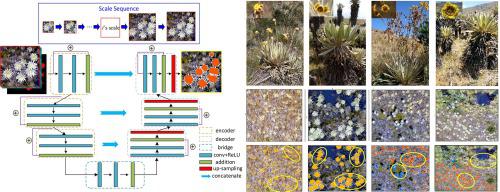
The identification and counting of plant individuals is essential for environmental monitoring. UAV based imagery offer ultra-fine spatial resolution and flexibility in data acquisition, and so provide a great opportunity to enhance current plant and in-situ field surveying. However, accurate mapping of individual plants from UAV imagery remains challenging, given the great variation in the sizes and geometries of individual plants and in their distribution. This is true even for deep learning based semantic segmentation and classification methods. In this research, a novel Scale Sequence Residual U-Net (SS Res U-Net) deep learning method was proposed, which integrates a set of Residual U-Nets with a sequence of input scales that can be derived automatically. The SS Res U-Net classifies individual plants by continuously increasing the patch scale, with features learned at small scales passing gradually to larger scales, thus, achieving multi-scale information fusion while retaining fine spatial details of interest. The SS Res U-Net was tested to identify and map frailejones (all plant species of the subtribe Espeletiinae), the dominant plants in one of the world’s most biodiverse high-elevation ecosystems (i.e. the páramos) from UAV imagery. Results demonstrate that the SS Res U-Net has the ability to self-adapt to variation in objects, and consistently achieved the highest classification accuracy (91.67% on average) compared with four state-of-the-art benchmark approaches. In addition, SS Res U-Net produced the best performances in terms of both robustness to training sample size reduction and computational efficiency compared with the benchmarks. Thus, SS Res U-Net shows great promise for solving remotely sensed semantic segmentation and classification tasks, and more general machine intelligence. The prospective implementation of this method to identify and map frailejones in the páramos will benefit immensely the monitoring of their populations for conservation assessments and management, among many other applications.
中文翻译:
使用无人机图像和深度学习在高度多样化的高海拔生态系统中识别和绘制单个植物
植物个体的识别和计数对于环境监测至关重要。基于无人机的影像可提供超精细的空间分辨率和数据采集的灵活性,因此为增强当前工厂和现场状况提供了绝佳机会实地调查。但是,鉴于单个植物的大小和几何形状及其分布的巨大差异,从无人机图像中准确绘制单个植物的地图仍然具有挑战性。即使对于基于深度学习的语义分割和分类方法也是如此。在这项研究中,提出了一种新的尺度序列残差U-Net(SS Res U-Net)深度学习方法,该方法将一组残差U-Net与一系列可以自动导出的输入尺度相集成。SS Res U-Net通过不断增加斑块规模来对单个植物进行分类,从小规模学习到的特征逐渐过渡到更大规模,从而实现多尺度信息融合,同时保留感兴趣的精细空间细节。对SS Res U-Net进行了测试,以从无人机图像中识别并绘制脆弱类(脆弱纲的所有植物物种),脆弱类是世界上生物多样性最高的高海拔生态系统之一(即帕拉莫斯)中的优势植物。结果表明,与四种最新的基准测试方法相比,SS Res U-Net具有自适应对象变化的能力,并且始终达到最高的分类精度(平均为91.67%)。此外,与基准测试相比,SS Res U-Net在训练样本量减少的鲁棒性和计算效率方面均表现出最佳的性能。因此,SS Res U-Net在解决遥感语义分割和分类任务以及更通用的机器智能方面显示出巨大的希望。


 京公网安备 11010802027423号