当前位置:
X-MOL 学术
›
Remote Sens. Ecol. Conserv.
›
论文详情
Our official English website, www.x-mol.net, welcomes your feedback! (Note: you will need to create a separate account there.)
Remote sensing data fusion as a tool for biomass prediction in extensive grasslands invaded by L. polyphyllus
Remote Sensing in Ecology and Conservation ( IF 5.5 ) Pub Date : 2020-09-30 , DOI: 10.1002/rse2.182 Damian Schulze‐Brüninghoff 1 , Michael Wachendorf 1 , Thomas Astor 1
Remote Sensing in Ecology and Conservation ( IF 5.5 ) Pub Date : 2020-09-30 , DOI: 10.1002/rse2.182 Damian Schulze‐Brüninghoff 1 , Michael Wachendorf 1 , Thomas Astor 1
Affiliation
|
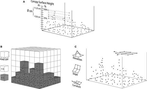
Remote sensing data fusion is a powerful tool to gain information of quantitative and qualitative vegetation properties on field level. The aim of this study was to develop prediction models from sensor data fusion for fresh and dry matter yield (FMY/DMY) in extensively managed grasslands with variable degree of invasion by Lupinus polyphyllus. Therefore, a terrestrial 3d laser scanner (TLS) and a drone-based hyperspectral camera was used to collect high resolution 3d point clouds and hyperspectral aerial orthomosaics of four extremely heterogenous grasslands. From 3d point clouds multiple features (vegetation height, sum of voxel, point density and surface structure) were extracted and combined with hyperspectral data to develop an optimized biomass model from random forest regression algorithm to predict FMY and DMY (ntrain = 130, ntest = 33). Models from hyperspectral data solitarily had the lowest prediction performance (FMY: R2 = 0.61, nRMSEr = 17.14; DMY: R2 = 0.59, nRMSEr = 19.37). Higher performance was gained by models derived from 3d laser data (FMY: R2 = 0. 76, nRMSEr = 13.3; DMY: R2 = 0. 74, nRMSEr = 15.1). A fusion of both sensor systems increased the FMY prediction performance up to R2 = 0.8; nRMSEr = 12.02 and the DMY prediction performance to R2 = 0.81 and nRMSEr = 12.06. The fusion of complementary sensor systems can increase the power to predict biomass yields of heterogenous and extensively managed grasslands. It is a novel alternative to labour-intensive, traditional biomass prediction methods and to remote sensing methods using only single sensor data.
中文翻译:

遥感数据融合作为 L. polyphyllus 入侵的大面积草地生物量预测的工具
遥感数据融合是获取田间植被定量和定性信息的有力工具。本研究的目的是开发来自传感器数据融合的预测模型,用于在具有不同程度入侵的羽扇豆入侵的广泛管理的草地中进行新鲜和干物质产量 (FMY/DMY)。. 因此,地面 3d 激光扫描仪 (TLS) 和基于无人机的高光谱相机用于收集四个极端异质草原的高分辨率 3d 点云和高光谱航空正射镶嵌。从 3d 点云中提取多个特征(植被高度、体素总和、点密度和表面结构),并与高光谱数据相结合,从随机森林回归算法中开发出优化的生物量模型,以预测 FMY 和 DMY(n train = 130, n测试 = 33)。来自高光谱数据的模型 单独具有最低的预测性能(FMY:R 2 = 0.61,nRMSE r = 17.14;DMY:R 2 = 0.59,nRMSE r = 19.37)。来自 3d 激光数据的模型获得了更高的性能(FMY:R 2 = 0. 76,nRMSE r = 13.3;DMY:R 2 = 0. 74,nRMSE r = 15.1)。两种传感器系统的融合将 FMY 预测性能提高到R 2 = 0.8;nRMSE r = 12.02 和 DMY 预测性能R 2 = 0.81 和 nRMSE r = 12.06。互补传感器系统的融合可以增加预测异质和广泛管理草地的生物量产量的能力。它是劳动密集型的传统生物量预测方法和仅使用单个传感器数据的遥感方法的新替代方案。
更新日期:2020-09-30
中文翻译:
遥感数据融合作为 L. polyphyllus 入侵的大面积草地生物量预测的工具
遥感数据融合是获取田间植被定量和定性信息的有力工具。本研究的目的是开发来自传感器数据融合的预测模型,用于在具有不同程度入侵的羽扇豆入侵的广泛管理的草地中进行新鲜和干物质产量 (FMY/DMY)。. 因此,地面 3d 激光扫描仪 (TLS) 和基于无人机的高光谱相机用于收集四个极端异质草原的高分辨率 3d 点云和高光谱航空正射镶嵌。从 3d 点云中提取多个特征(植被高度、体素总和、点密度和表面结构),并与高光谱数据相结合,从随机森林回归算法中开发出优化的生物量模型,以预测 FMY 和 DMY(n train = 130, n测试 = 33)。来自高光谱数据的模型 单独具有最低的预测性能(FMY:R 2 = 0.61,nRMSE r = 17.14;DMY:R 2 = 0.59,nRMSE r = 19.37)。来自 3d 激光数据的模型获得了更高的性能(FMY:R 2 = 0. 76,nRMSE r = 13.3;DMY:R 2 = 0. 74,nRMSE r = 15.1)。两种传感器系统的融合将 FMY 预测性能提高到R 2 = 0.8;nRMSE r = 12.02 和 DMY 预测性能R 2 = 0.81 和 nRMSE r = 12.06。互补传感器系统的融合可以增加预测异质和广泛管理草地的生物量产量的能力。它是劳动密集型的传统生物量预测方法和仅使用单个传感器数据的遥感方法的新替代方案。


 京公网安备 11010802027423号