Estuarine, Coastal and Shelf Science ( IF 2.8 ) Pub Date : 2020-09-24 , DOI: 10.1016/j.ecss.2020.107022 Nora M. Gilbertson , Thomas P. Adams , Michael T. Burrows
|
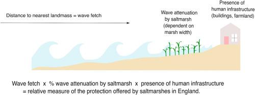
Saltmarshes and mudflats provide many valuable services to society, including coastal protection. Previous studies have established the nonlinearity of wave attenuation with habitat width, and variation with vegetation type. However, spatial variation in the level of coastal protection has not been quantified on a national scale. Spatial distribution and fine (50 m) scale structure of saltmarsh habitat at a national scale was combined with calculations of wave fetch at a 200 m scale. Effective wave exposure as a result of wave attenuation over habitat was calculated for areas of coastline within 5 km of habitat areas. Effective wave exposure was combined with data layers on building and farmland locations in order to assess relative protection provision. A metric of coastal protection was calculated for the entire coastline of England and Wales, based on the proximity of human infrastructure and farmland. In scaling existing local and regional data on coastal protection to a national level, we may examine how coastal protection varies regionally and provide a criterion for coastal ecosystem managers to select marshes critical for conservation. Our index shows greatest protection of human infrastructure by marshes in the east and south of the UK, where saltmarshes are on relatively open coastlines with nearby built-up areas and agriculture.
中文翻译:
从沼泽到海岸线:用于本地和国家规模识别高价值栖息地以进行海岸保护的指标
盐沼和滩涂为社会提供了许多有价值的服务,包括沿海保护。先前的研究已经建立了波衰减随生境宽度的非线性以及随植被类型的变化的非线性。但是,沿海保护水平的空间变化尚未在全国范围内量化。将全国范围内盐沼栖息地的空间分布和精细(50 m)尺度结构与200 m尺度上的取潮计算相结合。计算出栖息地5公里以内的海岸线区域因栖息地波浪衰减而产生的有效波浪暴露。有效的波浪暴露与建筑物和农田位置上的数据层结合在一起,以评估相对的保护措施。计算了英格兰和威尔士整个海岸线的沿海保护指标,基于人类基础设施和农田的接近性。在将现有的沿海保护本地和区域数据扩展到国家水平时,我们可能会研究沿海保护在区域之间的变化,并为沿海生态系统管理者选择对保护至关重要的沼泽提供标准。我们的指数显示了英国东部和南部的沼泽地对人类基础设施的最大保护,那里的盐沼位于相对开放的海岸线上,附近有建成区和农业。


 京公网安备 11010802027423号