Ecological Indicators ( IF 6.9 ) Pub Date : 2020-09-21 , DOI: 10.1016/j.ecolind.2020.106941 Quan Cui , Mohamed E. Ammar , Majid Iravani , Jahan Kariyeva , Monireh Faramarzi
|
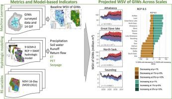
Geographically Isolated Wetlands (GIWs) are essential ecological and ecosystem entities that are vulnerable to climate change. The water storage volume (WSV) of GIWs is an important indicator to monitor their health and ecosystem services. Therefore, the projection of changes in future WSV of GIWs is crucial for conservation policies that are typically set at the regional scale. A limiting factor for the extended spatial projection of WSV of GIWs is the lack of data on their geometry, bathymetry, and the complexity of hydrologic relation to the surrounding drainage basin and the climate at a regional scale. In this study, we developed a hybrid Machine Learning (ML) – hydrologic modelling approach, from which a number of indices and variables derived to assess WSV of GIWs. We projected future changes in WSV of about a hundred thousand GIWs across 17 large river basins in western Canada, using a nine-model ensemble climate simulations under two greenhouse gas emissions scenarios (i.e., RCP 2.6 and RCP 8.5). We estimated the baseline WSV by developing ML models using water depth measurements and geographical information features from 234 surveyed GIWs across the study area. Future WSV was quantified using a three-step procedure, where water balance simulations were facilitated through the Soil and Water Assessment Tool (SWAT) for the 2018–2034 period, and GIW specific mass-balance components were adapted using remote sensing data. The spatiotemporal analysis of the WSV offers new insights, and reveals (1) a baseline provincial WSV of 550 million m3, with an average of 5,508 m3 per GIW, (2) a decreasing future WSV at annual rates of −2.58 and −2.62 million m3 for RCP 2.6 and RCP 8.5, respectively, and (3) the minimum and maximum WSV loss rates occurring during October and February, respectively, and (4) a diverse trend and magnitude of changes in WSV across 17 river basins. Finally, we state that while a group of hydrologic, climatic, and geographic processes and factors drives WSV of GIWs, the dominating driving force in WSV trends might be spatially and temporally different depending on the environmental conditions and characteristics of river basins and their associated GIWs. This study facilitates a better understanding of the connections between the WSV of GIWs and watershed-scale hydrology and climate change across multiple spatial scales.
中文翻译:
区域湿地储水量变化:未来气候对地理上孤立的湿地的影响
地理上隔离的湿地(GIW)是易受气候变化影响的重要生态和生态系统实体。GIW的储水量(WSV)是监测其健康和生态系统服务的重要指标。因此,对于通常在区域范围内制定的养护政策,预测未来GIW的WSV变化至关重要。GIW的WSV扩展空间投影的一个限制因素是缺乏有关其几何形状,水深的数据以及与周围流域和区域范围内气候的水文关系的复杂性。在这项研究中,我们开发了一种混合机器学习(ML)–水文建模方法,可从中得出许多指标和变量来评估GIW的WSV。我们使用两种温室气体排放情景(即RCP 2.6和RCP 8.5)下的九模式整体气候模拟,预测了加拿大西部17个大河流域中约十万个全球变暖潜能值的未来WSV变化。我们通过使用水深测量和来自研究区域的234个被调查GIW的地理信息特征开发ML模型,估计了基线WSV。未来的WSV使用三步程序进行了量化,其中通过土壤和水评估工具(SWAT)促进了2018-2034年的水平衡模拟,并且使用遥感数据对GIW特定的质量平衡成分进行了调整。WSV的时空分析提供了新的见解,并揭示了(1)5.5亿m 在两种温室气体排放情景(即RCP 2.6和RCP 8.5)下使用九模式整体气候模拟。我们通过使用水深测量和来自研究区域的234个被调查GIW的地理信息特征开发ML模型,估计了基线WSV。未来的WSV使用三步程序进行了量化,其中通过土壤和水评估工具(SWAT)促进了2018-2034年的水平衡模拟,并且使用遥感数据对GIW特定的质量平衡成分进行了调整。WSV的时空分析提供了新的见解,并揭示了(1)5.5亿m 在两种温室气体排放情景(即RCP 2.6和RCP 8.5)下使用九模式整体气候模拟。我们通过使用水深测量和来自研究区域的234个被调查GIW的地理信息特征开发ML模型,估计了基线WSV。未来的WSV使用三步程序进行了量化,其中通过土壤和水评估工具(SWAT)促进了2018-2034年的水平衡模拟,并且使用遥感数据对GIW特定的质量平衡成分进行了调整。WSV的时空分析提供了新的见解,并揭示了(1)5.5亿m 我们通过使用水深测量和来自研究区域的234个被调查GIW的地理信息特征开发ML模型,估计了基线WSV。未来的WSV使用三步程序进行了量化,其中通过土壤和水评估工具(SWAT)促进了2018-2034年的水平衡模拟,并且使用遥感数据对GIW特定的质量平衡成分进行了调整。WSV的时空分析提供了新的见解,并揭示了(1)5.5亿m 我们通过使用水深测量值和来自研究区域的234个被调查GIW的地理信息特征开发ML模型,估计了基线WSV。未来的WSV使用三步程序进行了量化,其中通过土壤和水评估工具(SWAT)促进了2018-2034年的水平衡模拟,并且使用遥感数据对GIW特定的质量平衡成分进行了调整。WSV的时空分析提供了新的见解,并揭示了(1)5.5亿m GIW特定的质量平衡组件使用遥感数据进行了修改。WSV的时空分析提供了新的见解,并揭示了(1)5.5亿m GIW特定的质量平衡组件使用遥感数据进行了修改。WSV的时空分析提供了新的见解,并揭示了(1)5.5亿m3,每GIW平均为5,508 m 3,(2)以-2.58和-262万m 3的年率降低未来的WSV分别针对RCP 2.6和RCP 8.5,以及(3)分别在10月和2月发生的最小和最大WSV损失率,以及(4)在17个流域中WSV的变化趋势和变化幅度。最后,我们指出,虽然一组水文,气候和地理过程和因素驱动了GIW的WSV,但根据环境条件和流域及其相关GIW的特征,WSV趋势中的主导驱动力可能在时空上有所不同。 。这项研究有助于更好地理解GIW的WSV与流域尺度的水文和跨多个空间尺度的气候变化之间的联系。


 京公网安备 11010802027423号