当前位置:
X-MOL 学术
›
Q. J. R. Meteorol. Soc.
›
论文详情
Our official English website, www.x-mol.net, welcomes your feedback! (Note: you will need to create a separate account there.)
How grid‐spacing and convection representation affected the wind speed forecasts of four polar lows
Quarterly Journal of the Royal Meteorological Society ( IF 8.9 ) Pub Date : 2020-09-20 , DOI: 10.1002/qj.3911 Matilda Hallerstig 1, 2, 3 , Linus Magnusson 2 , Erik W. Kolstad 1, 3 , Stephanie Mayer 1
Quarterly Journal of the Royal Meteorological Society ( IF 8.9 ) Pub Date : 2020-09-20 , DOI: 10.1002/qj.3911 Matilda Hallerstig 1, 2, 3 , Linus Magnusson 2 , Erik W. Kolstad 1, 3 , Stephanie Mayer 1
Affiliation
|
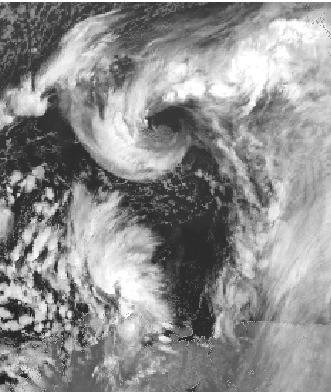
The horizontal resolution in numerical weather prediction models can have a large impact on the quality of polar low forecasts. However, there are few studies on the effect of the horizontal grid spacings which are currently in operational use at the European Centre for Medium‐Range Weather Forecasts (ECMWF). Here, we evaluate the 10 m wind speed forecasts for four polar lows in November and December 2016 against remote and in situ observations. We study the 18 km grid spacing, used in the ensemble, 9 km for the current operational deterministic model runs, and 5 km for the planned future deterministic runs. The 9 and 5 km versions fall within the range of grid spacings that resolve convection partly but not fully. Therefore, we also do sensitivity tests with and without deep convection parametrization. Finally, we examine the added value from the operational limited‐area model AROME‐Arctic with 2.5 km grid spacing. The 18 km version performed worst in magnitude of wind speed, but it did forecast the locations of the polar lows as well as the other models. Thus, the ensemble can be used for polar low probability products. The 5 and 9 km versions with parametrized convection were the best‐performing models over the ocean, while AROME‐Arctic was the best model along the coast and over land. The 5 and 9 km versions with resolved deep convection produced fewer but larger convective cells with patches of both under‐ and overestimation of wind speed. The fact that there was almost no difference between the 9 and 5 km grid spacing, but a clear impact from the handling of convection, suggests that, to improve polar low forecasts in the ECMWF deterministic runs, special attention to convection is needed.
中文翻译:

网格间距和对流表示如何影响四个极低点的风速预测
数值天气预报模型中的水平分辨率可能会对极地极低预报的质量产生重大影响。但是,关于水平网格间距的影响的研究很少,欧洲中距离天气预报中心(ECMWF)目前正在对其进行操作。在这里,我们评估了2016年11月和2016年12月相对偏远和原地的四个极低点的10 m风速预测观察。我们研究了集合中使用的18 km网格间距,当前运行确定性模型运行的9 km网格以及计划中的未来确定性运行的5 km。9 km和5 km版本位于部分解决但不完全解决对流问题的网格间距范围内。因此,我们还进行了有无深对流参数化的灵敏度测试。最后,我们检查了具有2.5 km网格间距的有限区域运营模型AROME-Arctic的增加值。18公里版本的风速表现最差,但它确实预测了极低点的位置以及其他模型。因此,该合奏可用于极性低概率乘积。参数对流的5公里和9公里版本是海洋上性能最佳的模型,而AROME-Arctic是沿海和陆地上最好的模型。解决深对流问题的5公里和9公里版本产生的对流单元数量较少,但对流单元却更大,同时对风速的估计值偏低和偏高。9 km和5 km的网格间距之间几乎没有差异,但是对流处理产生了明显影响,这表明,要改善ECMWF确定性运行中的极低预报,需要特别注意对流。
更新日期:2020-09-20
中文翻译:
网格间距和对流表示如何影响四个极低点的风速预测
数值天气预报模型中的水平分辨率可能会对极地极低预报的质量产生重大影响。但是,关于水平网格间距的影响的研究很少,欧洲中距离天气预报中心(ECMWF)目前正在对其进行操作。在这里,我们评估了2016年11月和2016年12月相对偏远和原地的四个极低点的10 m风速预测观察。我们研究了集合中使用的18 km网格间距,当前运行确定性模型运行的9 km网格以及计划中的未来确定性运行的5 km。9 km和5 km版本位于部分解决但不完全解决对流问题的网格间距范围内。因此,我们还进行了有无深对流参数化的灵敏度测试。最后,我们检查了具有2.5 km网格间距的有限区域运营模型AROME-Arctic的增加值。18公里版本的风速表现最差,但它确实预测了极低点的位置以及其他模型。因此,该合奏可用于极性低概率乘积。参数对流的5公里和9公里版本是海洋上性能最佳的模型,而AROME-Arctic是沿海和陆地上最好的模型。解决深对流问题的5公里和9公里版本产生的对流单元数量较少,但对流单元却更大,同时对风速的估计值偏低和偏高。9 km和5 km的网格间距之间几乎没有差异,但是对流处理产生了明显影响,这表明,要改善ECMWF确定性运行中的极低预报,需要特别注意对流。


 京公网安备 11010802027423号