当前位置:
X-MOL 学术
›
Ocean Coast Manage.
›
论文详情
Our official English website, www.x-mol.net, welcomes your feedback! (Note: you will need to create a separate account there.)
Sand transport in the northeastern Caribbean characterized by wind-wave-current data
Ocean & Coastal Management ( IF 4.6 ) Pub Date : 2020-12-01 , DOI: 10.1016/j.ocecoaman.2020.105363 Mark R. Jury
Ocean & Coastal Management ( IF 4.6 ) Pub Date : 2020-12-01 , DOI: 10.1016/j.ocecoaman.2020.105363 Mark R. Jury
|
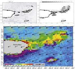
Abstract Sand transport around the northeastern Caribbean Virgin Islands (VI) is studied using global data-assimilation products and satellite measurements; with a focus on seasonal and event characteristics in the period 2002–2019. A review of applied research and a local statistical analysis indicate that currents accompanied by waves and wind mixing are capable of scouring near-shore sand bars. VI area (18.4–18.6N, 65.5–64.5W) time series analysis offer insights on the processes underlying suspended sediment concentrations estimated by 5 km resolution MODIS and VIIRS satellite red-band radiance. The winter season peak in turbidity derives from trade wind-driven waves and currents that reach critical thresholds to mobilize and transport the coarse sands. Instead of wave height, wave steepness and mixed layer depth are applied as coefficients to HYCOM3 near-surface currents, to create a multi-variate sand transport index. Statistical regression shows that a strengthened North Atlantic anticyclone and associated winter trade winds in the VI archipelago results in surface cooling and a deep mixed layer, making steep waves and westward currents more effective in sand transport. The leading case of satellite red-band radiance followed many months after the passage of tropical cyclones in September 2017. A sustained spell of intense trade winds in February 2018 induced 3 m waves of 3% steepness and near-surface currents up to 0.5 m/s. Rapid sea level oscillations >0.05 m suggest that long-period waves joined local wind-waves to mobilize coarse sands within a mixed layer >50 m deep. The plume of sand exhibited composite VIIRS red-band radiance of 0.1 W m−2 μm−1 sr −1; supplying coarse light-colored sands to downstream Caribbean islands. This study has universal application to near-shore sand transport by demonstrating the use of a high-resolution multi-variate index from freely available global data-assimilation products. Given rising sea levels, beach erosion and limited field data, such an index is an essential tool in coastal management.
中文翻译:

以风-浪-流数据为特征的加勒比东北部的沙子输送
摘要 利用全球资料同化产品和卫星测量研究了加勒比维尔京群岛 (VI) 东北部周围的沙子输送;重点关注 2002-2019 年期间的季节性和事件特征。应用研究回顾和当地统计分析表明,伴随波浪和风混合的洋流能够冲刷近岸沙洲。VI 区域(18.4-18.6N,65.5-64.5W)时间序列分析提供了对由 5 公里分辨率 MODIS 和 VIIRS 卫星红带辐射估计的悬浮沉积物浓度潜在过程的见解。冬季浊度高峰源于贸易风驱动的波浪和洋流,这些波浪和洋流达到临界阈值以动员和运输粗砂。而不是波高,波陡度和混合层深度作为系数应用于 HYCOM3 近地表水流,以创建多变量输沙指数。统计回归表明,北大西洋反气旋增强和相关的冬季信风在 VI 群岛导致地表冷却和深层混合层,使陡峭的波浪和西流更有效地输送沙子。2017 年 9 月热带气旋经过数月后,卫星红带辐射的主要案例出现了。 2018 年 2 月持续的强烈信风引发了 3 m 的陡度为 3% 的波浪和高达 0.5 m/ s。> 0.05 m 的快速海平面振荡表明,长周期波浪与当地风浪结合,在 > 50 m 深的混合层内移动粗砂。沙羽表现出复合 VIIRS 红波段辐射率为 0.1 W m-2 μm-1 sr -1;向下游的加勒比岛屿供应粗浅色沙子。这项研究通过展示使用来自免费提供的全球数据同化产品的高分辨率多变量指数,对近岸沙子运输具有普遍的应用。鉴于海平面上升、海滩侵蚀和有限的实地数据,这样的指数是海岸管理的重要工具。
更新日期:2020-12-01
中文翻译:
以风-浪-流数据为特征的加勒比东北部的沙子输送
摘要 利用全球资料同化产品和卫星测量研究了加勒比维尔京群岛 (VI) 东北部周围的沙子输送;重点关注 2002-2019 年期间的季节性和事件特征。应用研究回顾和当地统计分析表明,伴随波浪和风混合的洋流能够冲刷近岸沙洲。VI 区域(18.4-18.6N,65.5-64.5W)时间序列分析提供了对由 5 公里分辨率 MODIS 和 VIIRS 卫星红带辐射估计的悬浮沉积物浓度潜在过程的见解。冬季浊度高峰源于贸易风驱动的波浪和洋流,这些波浪和洋流达到临界阈值以动员和运输粗砂。而不是波高,波陡度和混合层深度作为系数应用于 HYCOM3 近地表水流,以创建多变量输沙指数。统计回归表明,北大西洋反气旋增强和相关的冬季信风在 VI 群岛导致地表冷却和深层混合层,使陡峭的波浪和西流更有效地输送沙子。2017 年 9 月热带气旋经过数月后,卫星红带辐射的主要案例出现了。 2018 年 2 月持续的强烈信风引发了 3 m 的陡度为 3% 的波浪和高达 0.5 m/ s。> 0.05 m 的快速海平面振荡表明,长周期波浪与当地风浪结合,在 > 50 m 深的混合层内移动粗砂。沙羽表现出复合 VIIRS 红波段辐射率为 0.1 W m-2 μm-1 sr -1;向下游的加勒比岛屿供应粗浅色沙子。这项研究通过展示使用来自免费提供的全球数据同化产品的高分辨率多变量指数,对近岸沙子运输具有普遍的应用。鉴于海平面上升、海滩侵蚀和有限的实地数据,这样的指数是海岸管理的重要工具。


 京公网安备 11010802027423号