Science of the Total Environment ( IF 9.8 ) Pub Date : 2020-09-17 , DOI: 10.1016/j.scitotenv.2020.142243 Alemu Yenehun , Fenta Nigate , Ashebir Sewale Belay , Minyahl Teferi Desta , Marc Van Camp , Kristine Walraevens
|
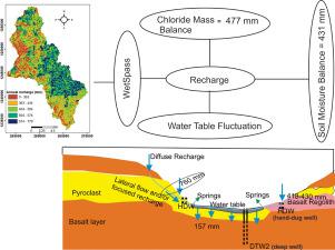
Groundwater recharge estimation, aquifer response to meteorological variables, and evapotranspiration calculations have been performed on a semi-humid catchment, in northwestern Ethiopian plateau. The Soil Moisture Balance (SMB), WetSpass water balance model, Water Table Fluctuation (WTF), and Chloride Mass Balance (CMB) methods are applied to estimate the groundwater recharge. Accordingly, 431 mm, 462 mm, and 477 mm recharge amounts are estimated as mean annual value, respectively, using SMB, WetSpass, and CMB methods. Based on the WTF method, the annual recharge rates of the volcanic aquifers are ranging from 157 mm to 760 mm, respectively. The SMB and WetSpass methods are less effective for the flat physiographic area, where the recharge rate is storage controlled rather than precipitation amount. The calculated high recharge for maintain-front aquifers using WTF is attributed to extra rising due to lateral groundwater flow, which restricts the reliability of the method for such aquifer geometries. High groundwater level rising rate (121 mm/day) has been observed for the steeply sloping, low rates (11 mm/day) for the flat floodplain, and intermediate rate (52 mm/day) for the gently sloping volcanic aquifers. Similarly, receding rates of 3.18 mm/day were found for the steeply sloping, 0.40 mm/day for the floodplain, and 1.14 mm/day for the gentle sloping aquifers. The recession, in all of the topographies, is happening with second-order polynomial decay function. A strong connection between the shallow and deep groundwater aquifers is noted. Storage change in the relatively deeper volcanic aquifers is due to vertical groundwater flow from the overlying alluvial aquifer. This indicates that the recharge mechanism is local, and may be the reason for the low aquifer productivity of the Dangila wellfield. Diurnal water table fluctuation is detrended from the receding trend of the dry period, and evapotranspiration from the groundwater is estimated at 28% of total ET.
中文翻译:
地下水补给和地下水位对不同生理条件下含水层变化条件的响应:埃塞俄比亚西北高原半湿润河流集水区
在西北埃塞俄比亚高原的一个半湿润集水区进行了地下水补给估算,含水层对气象变量的响应以及蒸散计算。应用土壤水分平衡(SMB),WetSpass水平衡模型,地下水位波动(WTF)和氯化物质量平衡(CMB)方法来估算地下水的补给量。因此,使用SMB,WetSpass和CMB方法分别将431 mm,462 mm和477 mm的补给量估计为年平均值。根据WTF方法,火山含水层的年补给率分别为157 mm至760 mm。SMB和WetSpass方法对于平坦的生理区域效果较差,因为该区域的补给速率受存储控制,而不是降水量。使用WTF计算得出的维持锋面含水层的高补给量归因于地下水的侧向流动导致的额外上升,这限制了这种含水层几何结构方法的可靠性。对于陡坡,观测到较高的地下水位上升速率(121 mm /天),对于平坦的洪泛区,观测到较低的速率(11 mm / day),对于缓坡的火山含水层观测到中等速率(52 mm / day)。同样,陡坡的后退速率为3.18 mm /天,洪泛区的后退速率为0.40 mm /天,缓坡的含水层为1.14 mm /天。在所有地形中,衰退都是通过二阶多项式衰减函数发生的。注意到浅层和深层含水层之间有很强的联系。相对较深的火山含水层的储层变化是由于上冲冲含水层产生的垂直地下水流所致。这表明补给机制是局部的,这可能是Dangila井场含水层生产率低的原因。干旱时期的后退趋势消除了地下水的日波动,估计地下水的蒸散量占总ET的28%。


 京公网安备 11010802027423号