当前位置:
X-MOL 学术
›
Q. J. R. Meteorol. Soc.
›
论文详情
Our official English website, www.x-mol.net, welcomes your feedback! (Note: you will need to create a separate account there.)
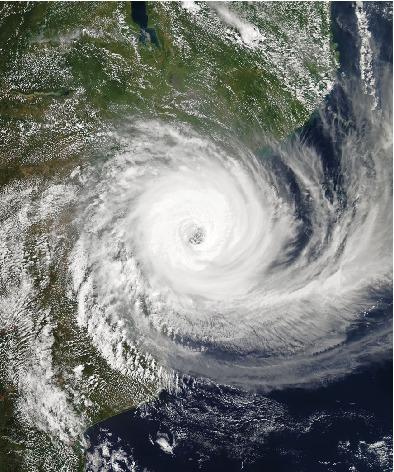
Prediction and precursors of Idai and 38 other tropical cyclones and storms in the Mozambique Channel
Quarterly Journal of the Royal Meteorological Society ( IF 8.9 ) Pub Date : 2020-09-09 , DOI: 10.1002/qj.3903 Erik W. Kolstad 1
Quarterly Journal of the Royal Meteorological Society ( IF 8.9 ) Pub Date : 2020-09-09 , DOI: 10.1002/qj.3903 Erik W. Kolstad 1
Affiliation
|
On average, about two tropical storms or cyclones enter or form in the Mozambique Channel between the African mainland and Madagascar each year. Their impact can be devastating. The tropical cyclone Idai, which hit land in Mozambique in 2019, was one of the deadliest storms on record in the Southern Hemisphere. Previous studies have found that the tracks and strengths of tropical storms and cyclones are difficult to predict more than a few days ahead. An extension of this forecast horizon would be crucial for enabling authorities to take precautionary actions. Here, the ability of the European Centre for Medium‐range Weather Forecasts (ECMWF) state‐of‐the‐art ensemble prediction model to predict Idai and 38 other tropical systems is assessed. Local wind speed maxima and sea‐level pressure (SLP) minima were predicted by about 25% of the ensemble members at lead times of 1–3 days but only about 5% of the members at 7–9 days' lead times. However, several variables showed potential as precursors of tropical storms and cyclones, and some of these could be predicted at long lead times. In particular, SLP anomalies, which were significantly lower than normal multiple days before the peaks of the storms, were skilfully predicted by the ensemble mean at lead times of at least 3 weeks. Specific humidity at 500 hPa and divergence at 200 hPa were higher than normal several days before the peaks, and these potential precursors were also forecasted with skill up to about 2 weeks in advance. The inclusion of forecasts of these variables as predictors in hybrid statistical–dynamical forecasting systems could potentially extend the time horizon for prediction and early detection of possible tropical storms and cyclones in the region.
中文翻译:

莫桑比克海峡Idai和其他38个热带气旋和风暴的预报和前兆
平均每年,非洲大陆和马达加斯加之间的莫桑比克海峡进入或形成约两次热带风暴或气旋。它们的影响可能是毁灭性的。热带气旋爱代(Idai)于2019年袭击莫桑比克的陆地,是南半球有记录以来最致命的风暴之一。先前的研究发现,热带风暴和旋风的轨迹和强度很难在几天之前预测出来。扩大这一预测范围对于使当局能够采取预防行动至关重要。在这里,欧洲中型天气预报中心(ECMWF)最新的集成预测模型预测Idai的能力评估了其他38个热带系统。大约25%的集合成员在1-3天的交付周期中预测了局部风速最大值和海平面压力(SLP)最小值,但是在7-9天的交付时间中,只有约5%的集合成员预测到。但是,一些变量显示出有可能成为热带风暴和气旋的先兆,并且其中一些可能在很长的交货期就可以预测到。特别是,在至少3周的交货时间之前,通过集合平均值巧妙地预测了SLP异常,该异常明显低于风暴高峰之前的几天。在峰值之前的几天,500 hPa的比湿度和200 hPa的散度高于正常值,并且这些潜在的前体也被提前了大约2周的技术进行了预测。
更新日期:2020-09-09
中文翻译:
莫桑比克海峡Idai和其他38个热带气旋和风暴的预报和前兆
平均每年,非洲大陆和马达加斯加之间的莫桑比克海峡进入或形成约两次热带风暴或气旋。它们的影响可能是毁灭性的。热带气旋爱代(Idai)于2019年袭击莫桑比克的陆地,是南半球有记录以来最致命的风暴之一。先前的研究发现,热带风暴和旋风的轨迹和强度很难在几天之前预测出来。扩大这一预测范围对于使当局能够采取预防行动至关重要。在这里,欧洲中型天气预报中心(ECMWF)最新的集成预测模型预测Idai的能力评估了其他38个热带系统。大约25%的集合成员在1-3天的交付周期中预测了局部风速最大值和海平面压力(SLP)最小值,但是在7-9天的交付时间中,只有约5%的集合成员预测到。但是,一些变量显示出有可能成为热带风暴和气旋的先兆,并且其中一些可能在很长的交货期就可以预测到。特别是,在至少3周的交货时间之前,通过集合平均值巧妙地预测了SLP异常,该异常明显低于风暴高峰之前的几天。在峰值之前的几天,500 hPa的比湿度和200 hPa的散度高于正常值,并且这些潜在的前体也被提前了大约2周的技术进行了预测。


 京公网安备 11010802027423号